
Dosya:Venus - 3D Perspective View of Maat Mons.jpg
Bu önizlemenin boyutu: 800 × 600 piksel. Diğer çözünürlükler: 320 × 240 piksel | 640 × 480 piksel | 1.024 × 768 piksel | 1.280 × 960 piksel | 2.560 × 1.920 piksel | 4.000 × 3.000 piksel.
Tam çözünürlük ((4.000 × 3.000 piksel, dosya boyutu: 1,09 MB, MIME tipi: image/jpeg))
Bu dosya Wikimedia Commons'ta bulunmaktadır. Dosyanın açıklaması aşağıda gösterilmiştir. Commons, serbest/özgür telifli medya dosyalarının bulundurulduğu depodur. Siz de yardım edebilirsiniz. |
| Açıklama |
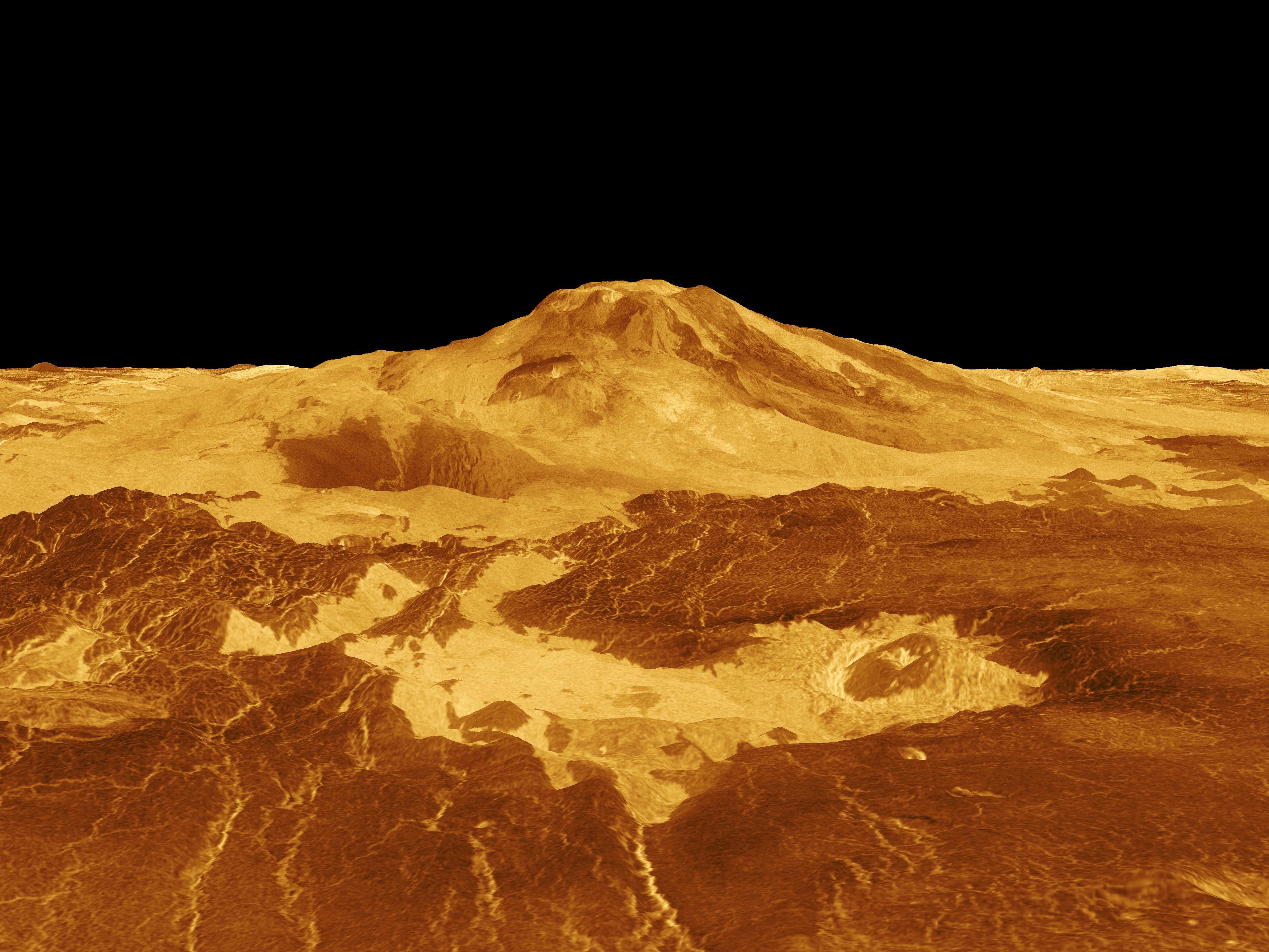
English: Maat Mons is displayed in this computer generated three-dimensional perspective of the surface of Venus. The viewpoint is located 634 kilometers (393 miles) north of Maat Mons at an elevation of 3 kilometers (2 miles) above the terrain. Lava flows extend for hundreds of kilometers across the fractured plains shown in the foreground, to the base of Maat Mons. The view is to the south with the volcano Maat Mons appearing at the center of the image on the horizon and rising to almost 5 kilometers (3 miles) above the surrounding terrain. Maat Mons is located at approximately 0.9 degrees north latitude, 194.5 degrees east longitude with a peak that ascends to 8 kilometers (5 miles) above the mean surface. Maat Mons is named for an Egyptian Goddess of truth and justice. Magellan synthetic aperture radar data is combined with radar altimetry to develop a three-dimensional map of the surface. The vertical scale in this perspective has been exaggerated 10 times. Rays cast in a computer intersect the surface to create a three-dimensional perspective view. Simulated color and a digital elevation map developed by the U.S. Geological Survey are used to enhance small-scale structure. The simulated hues are based on color images recorded by the Soviet Venera 13 and 14 spacecraft. The image was produced by the Solar System Visualization project and the Magellan Science team at the JPL Multimission Image Processing Laboratory and is a single frame from a video released at the April 22, 1992 news conference. Українська: Панорама Венери. Потоки лави на 400-км ділянці поверхні Венери |
|||||
| Tarih | ||||||
| Kaynak | http://photojournal.jpl.nasa.gov/catalog/PIA00106 | |||||
| Yazar |
|
|||||
| İzin (Bu dosyanın tekrar kullanımı) |
|

Dosya geçmişi
Dosyanın herhangi bir zamandaki hâli için ilgili tarih/saat kısmına tıklayın.
| Tarih/Saat | Küçük resim | Boyutlar | Kullanıcı | Yorum | |
|---|---|---|---|---|---|
| güncel | 10.34, 14 Şubat 2009 | | 4.000 × 3.000 (1,09 MB) | Complex01 | {{Information |Description={{en|1=Maat Mons is displayed in this computer generated three-dimensional perspective of the surface of Venus. The viewpoint is located 634 kilometers (393 miles) north of Maat Mons at an elevation of 3 kilometers (2 miles) abo |
Dosya kullanımı
Bu görüntü dosyasına bağlantısı olan sayfalar:
Küresel dosya kullanımı
Aşağıdaki diğer vikiler bu dosyayı kullanır:
- ar.wikipedia.org üzerinde kullanımı
- ca.wikipedia.org üzerinde kullanımı
- cy.wikipedia.org üzerinde kullanımı
- en.wikipedia.org üzerinde kullanımı
- es.wikipedia.org üzerinde kullanımı
- eu.wikipedia.org üzerinde kullanımı
- fr.wikipedia.org üzerinde kullanımı
- gl.wikipedia.org üzerinde kullanımı
- he.wikipedia.org üzerinde kullanımı
- it.wikipedia.org üzerinde kullanımı
- ja.wikipedia.org üzerinde kullanımı
- ja.wikibooks.org üzerinde kullanımı
- mk.wikipedia.org üzerinde kullanımı
- nl.wikipedia.org üzerinde kullanımı
- pl.wikipedia.org üzerinde kullanımı
- th.wikipedia.org üzerinde kullanımı
- uk.wikipedia.org üzerinde kullanımı
- www.wikidata.org üzerinde kullanımı
- zh.wikipedia.org üzerinde kullanımı