
Dosya:Solomon Islands 1989.jpg
Bu önizlemenin boyutu: 750 × 600 piksel. Diğer çözünürlükler: 300 × 240 piksel | 600 × 480 piksel | 961 × 768 piksel | 1.203 × 962 piksel.
Tam çözünürlük ((1.203 × 962 piksel, dosya boyutu: 131 KB, MIME tipi: image/jpeg))
Bu dosya Wikimedia Commons'ta bulunmaktadır. Dosyanın açıklaması aşağıda gösterilmiştir. Commons, serbest/özgür telifli medya dosyalarının bulundurulduğu depodur. Siz de yardım edebilirsiniz. |
Özet
| Açıklama |
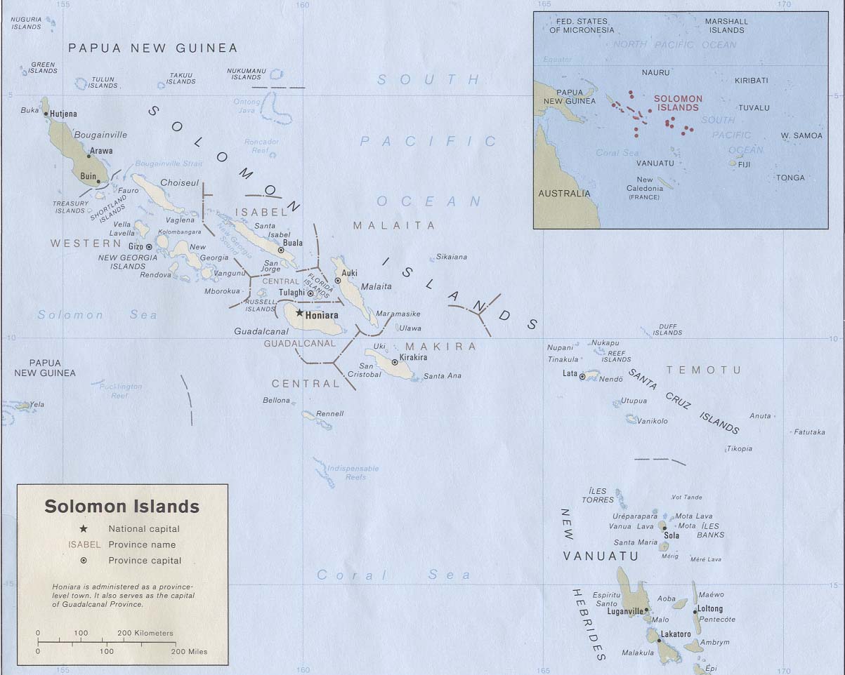
English: Map of the Solomon Islands as of 1989. Province names are included, except for two new provinces as of 1995: the Rennell and Bellona Province (formerly part of Central Province) and the Choiseul Province (formerly part of Western Province). |
| Tarih | |
| Kaynak | Solomon Islands (Political) 1989 from Perry-Castañeda Library Map Collection: Solomon Islands Maps. Cropped to remove white space from edges of map. |
| Yazar | U.S. Central Intelligence Agency |
| İzin (Bu dosyanın tekrar kullanımı) |
Public domain |
Lisanslama
| This image is a work of a Central Intelligence Agency employee, taken or made as part of that person's official duties. As a Work of the United States Government, this image or media is in the public domain in the United States.
|

|
Dosya geçmişi
Dosyanın herhangi bir zamandaki hâli için ilgili tarih/saat kısmına tıklayın.
| Tarih/Saat | Küçük resim | Boyutlar | Kullanıcı | Yorum | |
|---|---|---|---|---|---|
| güncel | 19.27, 25 Ağustos 2009 | | 1.203 × 962 (131 KB) | Zyxw | == {{int:filedesc}} == {{Information | description = {{en|Map of the Solomon Islands as of 1989. Province names are included, except for two new provinces as of 1995: the [[:en:Rennell and B |
Dosya kullanımı
Bu görüntü dosyasına bağlantısı olan sayfalar:
Küresel dosya kullanımı
Aşağıdaki diğer vikiler bu dosyayı kullanır:
- af.wikipedia.org üzerinde kullanımı
- ar.wikipedia.org üzerinde kullanımı
- az.wiktionary.org üzerinde kullanımı
- bg.wikipedia.org üzerinde kullanımı
- br.wikipedia.org üzerinde kullanımı
- ca.wikipedia.org üzerinde kullanımı
- cs.wikipedia.org üzerinde kullanımı
- en.wikipedia.org üzerinde kullanımı
- es.wikipedia.org üzerinde kullanımı
- eu.wikipedia.org üzerinde kullanımı
- fr.wikipedia.org üzerinde kullanımı
- gl.wikipedia.org üzerinde kullanımı
- hr.wikipedia.org üzerinde kullanımı
- hu.wikipedia.org üzerinde kullanımı
- hy.wikipedia.org üzerinde kullanımı
- id.wikipedia.org üzerinde kullanımı
- pa.wikipedia.org üzerinde kullanımı
- pl.wikipedia.org üzerinde kullanımı
- pl.wiktionary.org üzerinde kullanımı
- pt.wikipedia.org üzerinde kullanımı
- ro.wikipedia.org üzerinde kullanımı
- ru.wikipedia.org üzerinde kullanımı
- sco.wikipedia.org üzerinde kullanımı
- simple.wikipedia.org üzerinde kullanımı
- su.wikipedia.org üzerinde kullanımı
- tpi.wikipedia.org üzerinde kullanımı
- uk.wikipedia.org üzerinde kullanımı
- wuu.wikipedia.org üzerinde kullanımı
Bu dosyanın daha fazla küresel kullanımını görüntüle.