Dosya:Mars Map.JPG

Sayfa içeriği diğer dillerde desteklenmemektedir.
Vikipedi, özgür ansiklopedi

Tam çözünürlük((2.180 × 1.244 piksel, dosya boyutu: 2,33 MB, MIME tipi: image/jpeg))


Özet

Açıklama
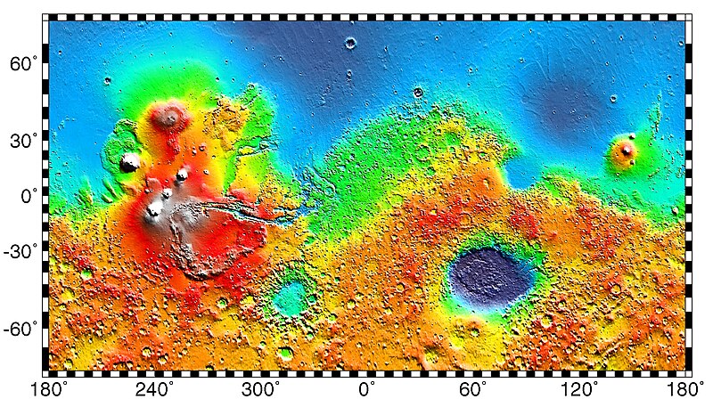
English: PIA02031: Maps of Mars Global Topography - Maps of Mars' global topography. The projections are Mercator to 70° latitude and stereographic at the poles with the south pole at left and north pole at right. Note the elevation difference between the northern and southern hemispheres. The Tharsis volcano-tectonic province is centered near the equator in the longitude range 220° E to 300° E and contains the vast east-west trending Valles Marineris canyon system and several major volcanic shields including Olympus Mons (18° N, 225° E), Alba Patera (42° N, 252° E), Ascraeus Mons (12° N, 248° E), Pavonis Mons (0°, 247° E), and Arsia Mons (9° S, 239° E). Regions and structures discussed in the text include Solis Planum (25° S, 270° E), Lunae Planum (10° N, 290° E), and Claritas Fossae (30° S, 255° E). Major impact basins include Hellas (45° S, 70° E), Argyre (50° S, 320° E), Isidis (12° N, 88° E), and Utopia (45° N, 110° E). This analysis uses an areocentric coordinate convention with east longitude positive.

Color coding on this map of the planet Mars indicates relative elevations based on data from the Mars Orbiter Laser Altimeter on NASA's Mars Global Surveyor. Red is higher elevation (up to +8 km and higher); yellow is 0 km; blue is lower elevation (down to -8 km). In longitude, the map extends from 70 degrees (north) to minus 70 degrees (south). The east-west axis is labeled at the bottom in degrees of east longitude, with the zero meridian at the center.

Data was produced by the Mars Global Surveyor's MOLA instrument

  • Producer ID: P50409 MRPS95009
Português: Mapa de Marte.
Русский: Карта Марса.
Tarih (released)
Kaynak http://photojournal.jpl.nasa.gov/catalog/PIA02031 (image link)
Yazar NASA/JPL/GSFC
İzin
(Bu dosyanın tekrar kullanımı)
https://www.jpl.nasa.gov/imagepolicy/
Diğer sürümler

Related Templates:

Related Images:

Bu görüntü veya video ABD Ulusal Havacılık ve Uzay Dairesi (NASA) Jet Propulsion Labtarafından Fotoğraf ID: PIA02031 ile kataloğa alınmıştır.

Bu etiket, ekli çalışmanın telif hakkı durumunu göstermez. Normal bir telif hakkı etiketi hâlâ gereklidir. Commons:Lisanslama sayfasına bakın.
Diğer diller:

Lisanslama

Public domain Bu dosya NASA tarafından üretildiği için kamu malıdır. Aksi belirtilmediği sürece "NASA tarafından üretilen malzemenin telif hakkı olmadığı" NASA telif politikasında belirtilmiştir. (Bkz. Template:PD-USGov, NASA copyright policy page veya JPL Image Use Policy.)
Uyarılar:

Orijinal yükleme günlüğü

Dosyanın orjinal açıklama sayfası burada bulunmaktadır. Aşağıdaki tüm kullanıcı adları için en.wikipedia bakın.
  • 2012-10-26 05:43 Kelvin Case 613×350× (142399 bytes) {{Information |Description= {{en|Map of mars.}} {{pt|Mapa de Marte.}} http://photojournal.jpl.nasa.gov/catalog/PIA02031 PIA02031: Maps of Mars Global Topography Target Name:Mars Is a satellite of:Sol (our sun) Mission: Mars Global Surveyor (MGS) ...

Altyazılar

Bu dosyanın temsil ettiği şeyin tek satırlık açıklamasını ekleyin.

Bu dosyada gösterilen öğeler

betimlenen

27 Mayıs 1999

Dosya geçmişi

Dosyanın herhangi bir zamandaki hâli için ilgili tarih/saat kısmına tıklayın.

Tarih/SaatKüçük resimBoyutlarKullanıcıYorum
güncel02.57, 4 Mayıs 201902.57, 4 Mayıs 2019 tarihindeki sürümün küçültülmüş hâli2.180 × 1.244 (2,33 MB)HuntsterFull resolution from NASA/JPL.
09.23, 6 Mayıs 201409.23, 6 Mayıs 2014 tarihindeki sürümün küçültülmüş hâli613 × 350 (139 KB)Wikiuser13Transferred from en.wikipedia

Küresel dosya kullanımı

Aşağıdaki diğer vikiler bu dosyayı kullanır:

Bu dosyanın daha fazla küresel kullanımını görüntüle.

Meta veri