
Dosya:Map of the United States with flags with territories and DC final2.png
Bu önizlemenin boyutu: 800 × 505 piksel. Diğer çözünürlükler: 320 × 202 piksel | 640 × 404 piksel | 1.024 × 646 piksel | 1.600 × 1.010 piksel.
Tam çözünürlük ((1.600 × 1.010 piksel, dosya boyutu: 518 KB, MIME tipi: image/png))
Bu dosya Wikimedia Commons'ta bulunmaktadır. Dosyanın açıklaması aşağıda gösterilmiştir. Commons, serbest/özgür telifli medya dosyalarının bulundurulduğu depodur. Siz de yardım edebilirsiniz. |
Özet
| Açıklama |
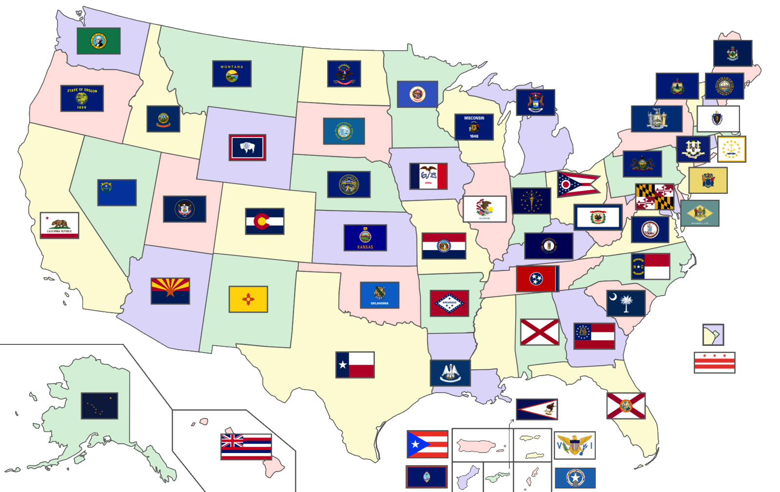
English: A map of the United States showing the flags of the 50 U.S. states, the District of Columbia, and the 5 inhabited U.S. territories (Total number of flags: 56) |
| Tarih | |
| Kaynak | Modified version of map already on Wikimedia Commons; Flags are in public domain |
| Yazar | Original author: User:SiBr4 |
Lisanslama
Bu dosya, Creative Commons Atıf-Benzer Paylaşım 3.0 Taşınmamış lisansı ile lisanslanmıştır
- Şu seçeneklerde özgürsünüz:
- paylaşım – eser paylaşımı, dağıtımı ve iletimi
- içeriği değiştirip uyarlama – eser adaptasyonu
- Aşağıdaki koşullar geçerli olacaktır:
- atıf – Esere yazar veya lisans sahibi tarafından belirtilen (ancak sizi ya da eseri kullanımınızı desteklediklerini ileri sürmeyecek bir) şekilde atıfta bulunmalısınız.
- benzer paylaşım – Maddeyi yeniden karıştırır, dönüştürür veya inşa ederseniz, katkılarınızı orijinal olarak aynı veya uyumlu lisans altında dağıtmanız gerekir.
Dosya geçmişi
Dosyanın herhangi bir zamandaki hâli için ilgili tarih/saat kısmına tıklayın.
| Tarih/Saat | Küçük resim | Boyutlar | Kullanıcı | Yorum | |
|---|---|---|---|---|---|
| güncel | 16.00, 10 Kasım 2020 | | 1.600 × 1.010 (518 KB) | CapLiber | transparent background |
| 18.57, 20 Ekim 2020 |  | 1.600 × 1.010 (571 KB) | The Image Editor | Updated New York flag as of April 2020 | |
| 20.55, 17 Ağustos 2020 |  | 2.000 × 1.263 (557 KB) | Davidwr | Reverted to version as of 01:39, 29 June 2020 (UTC) - the August 10 version was missing territorial flags | |
| 05.36, 10 Ağustos 2020 |  | 2.000 × 1.263 (493 KB) | RootOfAllLight | N/A | |
| 01.39, 29 Haziran 2020 |  | 2.000 × 1.263 (557 KB) | BasilLeaf | State of Mississipi wil officially have no flag until at least November 3rd, 2020, as per State law passed on June 28th, 2020. | |
| 17.03, 7 Eylül 2019 |  | 2.000 × 1.263 (390 KB) | LumaP15 | User created page with UploadWizard |
Dosya kullanımı
Bu görüntü dosyasına bağlantısı olan sayfalar:
Küresel dosya kullanımı
Aşağıdaki diğer vikiler bu dosyayı kullanır:
- ml.wikipedia.org üzerinde kullanımı