Dosya:Map of East Williamsburg (2009).jpg

Sayfa içeriği diğer dillerde desteklenmemektedir.
Vikipedi, özgür ansiklopedi

Tam çözünürlük((991 × 910 piksel, dosya boyutu: 831 KB, MIME tipi: image/jpeg))


Özet

Açıklama
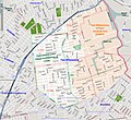
English: The East Williamsburg section of Brooklyn, NY, is shown in highlight in the center of the map. There is no official definition of the East Williamsburg boundaries, so this map serves only as a guide. The original 3rd District of the Village of Williamsburg, annexed to Williamsburg in 1835, is shown in light green. The East Williamsburg In-Place Industrial Park (EWIPIP), as defined by the City of New York, is shown in light orange. The lavender line that follows Flushing Avenue, from left to right on the map, denotes the border between Community District 1 (to the North) and Community District 4 to the South. Postal districts are delineated by light red lines, with ZIP Codes given in light red font.

The boundaries of the 3rd district can be found in "A Map of Williamsburgh", Isaac Vieth, Brooklyn, 1845. "The Village is divided into three districts, numbered one two and three. All west of the centre of Union Ave and south of the centre of Grand Street composes the first district; all west of Union Avenue and to the north of Grand Street composes the Second District; and all east of Union Avenue, the Third District."

The boundaries of the East Williamsburg In-Place Industrial Park (EWIPIP) are defined by the City of New York and can be found, for example, at Map of CD1 Industrial Study Areas.
Tarih
Kaynak OpenStreetMap
Yazar OpenStreetMap

Lisanslama

w:tr:Creative Commons
atıf benzer paylaşım
Bu dosya, Creative Commons Atıf-Benzer Paylaşım 3.0 Taşınmamış lisansı ile lisanslanmıştır
Şu seçeneklerde özgürsünüz:
  • paylaşım – eser paylaşımı, dağıtımı ve iletimi
  • içeriği değiştirip uyarlama – eser adaptasyonu
Aşağıdaki koşullar geçerli olacaktır:
  • atıf – Esere yazar veya lisans sahibi tarafından belirtilen (ancak sizi ya da eseri kullanımınızı desteklediklerini ileri sürmeyecek bir) şekilde atıfta bulunmalısınız.
  • benzer paylaşım – Maddeyi yeniden karıştırır, dönüştürür veya inşa ederseniz, katkılarınızı orijinal olarak aynı veya uyumlu lisans altında dağıtmanız gerekir.

Altyazılar

Bu dosyanın temsil ettiği şeyin tek satırlık açıklamasını ekleyin.

Bu dosyada gösterilen öğeler

betimlenen

3 Mayıs 2009

image/jpeg

Dosya geçmişi

Dosyanın herhangi bir zamandaki hâli için ilgili tarih/saat kısmına tıklayın.

Tarih/SaatKüçük resimBoyutlarKullanıcıYorum
güncel01.04, 9 Mart 200901.04, 9 Mart 2009 tarihindeki sürümün küçültülmüş hâli991 × 910 (831 KB)Repliedthemockturtleadded community districts
22.06, 8 Mart 200922.06, 8 Mart 2009 tarihindeki sürümün küçültülmüş hâli991 × 910 (821 KB)Repliedthemockturtleadded subways
19.15, 8 Mart 200919.15, 8 Mart 2009 tarihindeki sürümün küçültülmüş hâli991 × 910 (810 KB)RepliedthemockturtleHighlighted the EWIPIP and 3rd district
03.10, 6 Mart 200903.10, 6 Mart 2009 tarihindeki sürümün küçültülmüş hâli991 × 910 (799 KB)RepliedthemockturtleReverted to version as of 03:08, 6 March 2009
03.09, 6 Mart 200903.09, 6 Mart 2009 tarihindeki sürümün küçültülmüş hâli991 × 910 (799 KB)Repliedthemockturtle
03.08, 6 Mart 200903.08, 6 Mart 2009 tarihindeki sürümün küçültülmüş hâli991 × 910 (799 KB)Repliedthemockturtlelabeled the parks and creeks
02.22, 6 Mart 200902.22, 6 Mart 2009 tarihindeki sürümün küçültülmüş hâli991 × 910 (785 KB)Repliedthemockturtle{{Information |Description=The East Williamsburg section of Brooklyn, NY, is shown in highlight on the map. The boundary of the original 3rd District of the Village of Williamsburg is shown in light green. The lavender line that follows Flushing Aven

Bu görüntü dosyasına bağlantısı olan sayfalar:

Küresel dosya kullanımı

Aşağıdaki diğer vikiler bu dosyayı kullanır: