
Dosya:Bermuda wv.jpg
Daha yüksek çözünürlüğe sahip sürüm bulunmamaktadır.
Bermuda_wv.jpg ((800 × 600 piksel, dosya boyutu: 335 KB, MIME tipi: image/jpeg))
Bu dosya Wikimedia Commons'ta bulunmaktadır. Dosyanın açıklaması aşağıda gösterilmiştir. Commons, serbest/özgür telifli medya dosyalarının bulundurulduğu depodur. Siz de yardım edebilirsiniz. |
Özet
| Açıklama |
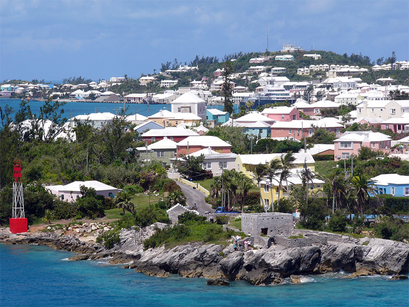
English: Residential suburb near the old St. George's Garrison, with "Town Cut Battery" or "Gate's Fort" in the foreground (with Cut Road behind it), on the northern side of the Town Cut shipping channel, and St. George's Town and harbour in the background, with Fort George on the peak of Mount Hill beyond, and a small ship is visible docked at Ordnance Island, off the town square]].
The Town Cut had been a minor channel, suitable only for small vessels to enter or exit the harbour, until dredged before the First World War. Before then, larger vessels had used the St. George's Channel between Paget Island and Governor's Island, which was watched over by Fort Paget (on Paget Island) and Smith's Fort (on Governor's Island). In the 19th Century, Fort Cunningham was erected on Paget Island, making all three of the earlier batteries redundant. Alexandra Battery (at Building Bay on St. George's Island, immediately to the north of Cut Battery) and St. David's Battery on St. David's Island were later added (there were also three other forts armed with coastal artillery batteries to the North-West of Building Bay: Fort St. Catherine's at St. Catherine's Point, and Fort Victoria and Fort Albert on Retreat Hill, to its rear). St. George's Town and the various forts and related military installations at the East End of Bermuda are together a United Nations Educational, Scientific and Cultural Organization's (UNESCO) World Heritage Site, the Historic Town of St George and Related Fortifications, Bermuda.[1][2] |
| Tarih | 24 Ağustos 2006 (original upload date) |
| Kaynak | Yükleyenin kendi çalışması |
| Yazar | (WT-en) Legrospaumé at İngilizce Vikigezgin |
| Kamera pozisyonu | | Bu ve diğer görüntülerin konumlarını şurada belirle: OpenStreetMap |
|---|
References
- ↑ Bermuda Forts 1612–1957, Dr. Edward C. Harris, The Bermuda Maritime Museum Press, The Bermuda Maritime Museum, P.O. Box MA 133, Mangrove Bay, Bermuda MA BX, ISBN 0-921560-11-7
- ↑ UNESCO World Heritage Centre: Historic Town of St George and Related Fortifications, Bermuda
Lisanslama
| Bu iş yazarı (WT-en) Legrospaumé at İngilizce Vikigezgin tarafından kamu malı olarak yayınlanmıştır. Bu dünya çapında geçerlidir. Bazı ülkelerde bu yasal olarak mümkün olmayabilir; öyleyse: (WT-en) Legrospaumé at İngilizce Vikigezgin, bu işi herhangi bir amaç için, herhangi bir şart olmaksızın, yasalarca gerekli olmadıkça, herkesin kullanmasına izin veriyor.
|
Orijinal yükleme günlüğü
| This file was imported from Wikivoyage en. |
Dosyanın orjinal açıklama sayfası burada bulunmaktadır. Aşağıdaki tüm kullanıcı adları için en.wikivoyage-old bakın.
- 2006-08-24 12:07 (WT-en) Legrospaumé 800×600 (343391 bytes) Bermuda (Import from wikitravel.org/en)
Dosya geçmişi
Dosyanın herhangi bir zamandaki hâli için ilgili tarih/saat kısmına tıklayın.
| Tarih/Saat | Küçük resim | Boyutlar | Kullanıcı | Yorum | |
|---|---|---|---|---|---|
| güncel | 19.09, 8 Ocak 2013 | | 800 × 600 (335 KB) | MGA73bot2 | {{BotMoveToCommons|en.oldwikivoyage|year={{subst:CURRENTYEAR}}|month={{subst:CURRENTMONTHNAME}}|day={{subst:CURRENTDAY}}}} == {{int:filedesc}} == {{Information |description=Bermuda |date={{Date|2006|8|24}} (original upload date) |source={{Own}}<BR />{{... |
Dosya kullanımı
Bu görüntü dosyasına bağlantısı olan sayfalar:
Küresel dosya kullanımı
Aşağıdaki diğer vikiler bu dosyayı kullanır:
- el.wikipedia.org üzerinde kullanımı
- en.wikipedia.org üzerinde kullanımı
- en.wikivoyage.org üzerinde kullanımı
- es.wikivoyage.org üzerinde kullanımı
- fi.wikipedia.org üzerinde kullanımı
- gl.wikipedia.org üzerinde kullanımı
- id.wikipedia.org üzerinde kullanımı
- ja.wikipedia.org üzerinde kullanımı
- mt.wikipedia.org üzerinde kullanımı
- nl.wikipedia.org üzerinde kullanımı
- pt.wikipedia.org üzerinde kullanımı
- simple.wikipedia.org üzerinde kullanımı
- vi.wikipedia.org üzerinde kullanımı
- vi.wikivoyage.org üzerinde kullanımı