
Dosya:LIDAR field yield.jpg
Daha yüksek çözünürlüğe sahip sürüm bulunmamaktadır.
LIDAR_field_yield.jpg ((288 × 185 piksel, dosya boyutu: 110 KB, MIME tipi: image/jpeg))
Bu dosya Wikimedia Commons'ta bulunmaktadır. Dosyanın açıklaması aşağıda gösterilmiştir. Commons, serbest/özgür telifli medya dosyalarının bulundurulduğu depodur. Siz de yardım edebilirsiniz. |
Özet
| Açıklama |
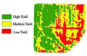
English: Agricultural Research Service researchers have developed a way to make more precise agricultural maps of fields from data generated by LIDAR (light detection and ranging) sensors to help farmers target more of their resources to the highest-yielding parts of their fields. |
| Tarih | |
| Kaynak | https://www.ars.usda.gov/is/pr/2010/100609.htm |
| Yazar | USDA/ARS/James M. McKinion |
Lisanslama
| Bu görüntü kamu malıdır çünkü içeriği, ABD Tarım Bakanlığı (United States Department of Agriculture) bünyesindeki bir araştırma dairesi olan Tarımsal Araştırma Servisi (Agricultural Research Service) kökenli özgün malzeme ile ilgilidir.
|
Orijinal yükleme günlüğü
en.wikipedia üzerinden Commons'a FtCG kullanarak transfer edildi.
Dosyanın orjinal açıklama sayfası burada bulunmaktadır. Aşağıdaki tüm kullanıcı adları için en.wikipedia bakın.
| Date/Time | Dimensions | User | Comment |
|---|---|---|---|
| 10:39, 7 September 2010 | 288 × 185 (112,175 bytes) | w:en:Huntster (Tartışma | katkılar) | (Crop and rm compression artifacts.) |
| 21:04, 17 August 2010 | 288 × 252 (77,555 bytes) | w:en:Wikiproject1400 (Tartışma | katkılar) | (Agricultural Research Service scientists have developed a way to incorporate LIDAR with yield rates on agricultural fields. This technology will help farmers direct their resources towars the high-yield sections of their land. (United States Department o) |
Dosya geçmişi
Dosyanın herhangi bir zamandaki hâli için ilgili tarih/saat kısmına tıklayın.
| Tarih/Saat | Küçük resim | Boyutlar | Kullanıcı | Yorum | |
|---|---|---|---|---|---|
| güncel | 10.24, 31 Aralık 2011 | | 288 × 185 (110 KB) | Huntster | Transferred from en.wikipedia: see original upload log above |
Dosya kullanımı
Bu görüntü dosyasına bağlanan sayfa yok.
Küresel dosya kullanımı
Aşağıdaki diğer vikiler bu dosyayı kullanır: