
Dosya:United Kingdom United States Locator.svg

Bu SVG dosyasının PNG önizlemesinin boyutu: 800 × 353 piksel. Diğer çözünürlükler: 320 × 141 piksel | 640 × 283 piksel | 1.024 × 452 piksel | 1.280 × 565 piksel | 2.560 × 1.130 piksel | 940 × 415 piksel.
Tam çözünürlük (SVG dosyası, sözde 940 × 415 piksel, dosya boyutu: 2,56 MB)
Bu dosya Wikimedia Commons'ta bulunmaktadır. Dosyanın açıklaması aşağıda gösterilmiştir. Commons, serbest/özgür telifli medya dosyalarının bulundurulduğu depodur. Siz de yardım edebilirsiniz. |
Özet
| Açıklama |
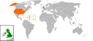
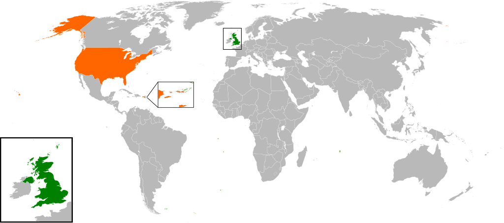
English: Map of the world showing the location of the United Kingdom and the United States of America. |
| Tarih | |
| Kaynak | Yükleyenin kendi çalışması |
| Yazar | Jolly Janner |
Lisanslama
| Ben, bu işin telif sahibi, bu işi kamu malı olarak yayınlıyorum. Bu dünya çapında geçerlidir. Bazı ülkelerde bu yasal olarak mümkün olmayabilir; öyleyse: Ben, bu işi herhangi bir amaç için, herhangi bir şart olmaksızın, yasalarca gerekli olmadıkça, herkesin kullanmasına izin veriyorum. |
Dosya geçmişi
Dosyanın herhangi bir zamandaki hâli için ilgili tarih/saat kısmına tıklayın.
| Tarih/Saat | Küçük resim | Boyutlar | Kullanıcı | Yorum | |
|---|---|---|---|---|---|
| güncel | 16.00, 20 Mart 2017 | | 940 × 415 (2,56 MB) | RaviC | add dependencies, inset map for Virgin Islands region where both states share a maritime border |
| 02.43, 24 Aralık 2016 |  | 940 × 415 (1,79 MB) | BurritoBazooka | put all Faroe islands except Suðuroy region behind black border of UK box. Make two boxes (transparent group rectangle and white bg rectangle) same stroke thickness. | |
| 00.43, 24 Aralık 2016 |  | 940 × 415 (1,79 MB) | BurritoBazooka | add France and Faroe Islands to UK box by re-cutting it from its place on the map (b/c why should ROI, another sovereign state, be shown, and not France and the Faroe Islands?) Also the box has its own group now. | |
| 00.34, 24 Aralık 2016 |  | 940 × 415 (1,78 MB) | BurritoBazooka | French Polynesia, Pitcairn Islands were showing in the UK box, but these are not in the same area as the British Isles at all. Also, are Falklands etc not on the same level as Puerto Rico? | |
| 18.38, 7 Aralık 2016 |  | 940 × 415 (1,78 MB) | Mikey641 | Accident | |
| 18.38, 7 Aralık 2016 |  | 512 × 226 (753 KB) | Mikey641 | -- | |
| 18.09, 3 Mart 2013 |  | 940 × 415 (1,78 MB) | Timothy Gu | +South Sudan (w/ small Britain map) | |
| 21.25, 2 Mart 2012 |  | 940 × 415 (1,63 MB) | Jrobin08 | Reverted to version as of 20:37, 24 June 2009 (Easier to see the United Kingdom. Maybe someone can add South Sudan to the map, but keep the UK zoom box in.) | |
| 21.05, 23 Eylül 2011 |  | 940 × 415 (1,76 MB) | Bazonka2 | + South Sudan | |
| 20.37, 24 Haziran 2009 |  | 940 × 415 (1,63 MB) | Jolly Janner | {{Information |Description={{en|1=Map of the world showing the location of the United Kingdom and the United States of America.}} |Source=Own work by uploader |Author=Jolly Janner |Date=2009-0 |
Dosya kullanımı
Bu görüntü dosyasına bağlantısı olan sayfalar:
Küresel dosya kullanımı
Aşağıdaki diğer vikiler bu dosyayı kullanır:
- ar.wikipedia.org üzerinde kullanımı
- ca.wikipedia.org üzerinde kullanımı
- de.wikipedia.org üzerinde kullanımı
- en.wikipedia.org üzerinde kullanımı
- es.wikipedia.org üzerinde kullanımı
- fr.wikipedia.org üzerinde kullanımı
- he.wikipedia.org üzerinde kullanımı
- hy.wikipedia.org üzerinde kullanımı
- id.wikipedia.org üzerinde kullanımı
- it.wikipedia.org üzerinde kullanımı
- ja.wikipedia.org üzerinde kullanımı
- ps.wikipedia.org üzerinde kullanımı
- pt.wikipedia.org üzerinde kullanımı
- ru.wikipedia.org üzerinde kullanımı
- th.wikipedia.org üzerinde kullanımı
- uk.wikipedia.org üzerinde kullanımı
- www.wikidata.org üzerinde kullanımı
- zh.wikipedia.org üzerinde kullanımı