
Dosya:St Mary's church - geograph.org.uk - 1510544.jpg
Daha yüksek çözünürlüğe sahip sürüm bulunmamaktadır.
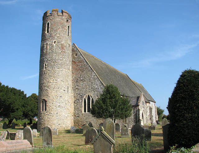
St_Mary's_church_-_geograph.org.uk_-_1510544.jpg ((640 × 493 piksel, dosya boyutu: 86 KB, MIME tipi: image/jpeg))
Bu dosya Wikimedia Commons'ta bulunmaktadır. Dosyanın açıklaması aşağıda gösterilmiştir. Commons, serbest/özgür telifli medya dosyalarının bulundurulduğu depodur. Siz de yardım edebilirsiniz. |
Özet
| Açıklama |
English: St Mary's church. There has been a church in Blundeston village since St. Fursey, an Irish Missionary, first preached Christianity in this area in the 7th century. Nothing remains of the original church. The round tower of St Mary's church > 1510597 was built around 988 and a century later nave and chancel were built onto the tower. A larger building replaced the Norman church in the 14th century, the widened nave offsetting the tower to the north. The font > 1510643 dates from this time. A second font - it can be seen outside by the priest door on the chancel south wall - was brought here from St Andrew's church in neighbouring Flixton. [St Andrew's church was destroyed in 1705 in a gale but the ruins can still be seen.] The rood screen dates from 1490, its faded panels depicting Angels of the Passion > 1510603. The royal arms are to Charles II > 1510624. St Mary's was extensively restored in the 1850s when the oak pews were fitted. Some of the pews have 14th century poppy heads > 1510620 attached to the bench ends. The church is open every day.
Blundeston is the birthplace of 'David Copperfield', in the novel of the same name by Charles Dickens. Despite local legend, it is difficult to tell whether Dickens actually visited here, or stayed at Somerleyton Hall > https://www.geograph.org.uk/photo/1506718 in the neighbouring village. |
| Tarih | |
| Kaynak | From geograph.org.uk |
| Yazar | Evelyn Simak |
| Atıf (required by the license) | Evelyn Simak / St Mary's church / |
_-_geograph.org.uk_-_1510603.jpg)
| Kamera pozisyonu | | Bu ve diğer görüntülerin konumlarını şurada belirle: OpenStreetMap |
|---|
_heading:45.00&language=tr)
| Nesne pozisyonu | | Bu ve diğer görüntülerin konumlarını şurada belirle: OpenStreetMap |
|---|
_heading:45.00&language=tr)
Lisanslama

|
Bu Coğrafya projesinden alınmış olan bir görüntüdür. Coğrafi internet sitesinde bulunan bu fotoğraf sayfasından fotoğrafçıya ait iletişim bilgilerine ulaşabilirsiniz. Bu görüntünün telif hakkı sahibi Evelyn Simak olup, yeniden kullanılması amacıyla Creative Commons Attribution-ShareAlike 2.0 lisansı ile lisanslandırılmıştır.
|
Bu dosya, Creative Commons Atıf-Benzer Paylaşım 2.0 Genel lisansı ile lisanslanmıştır
Atıf: Evelyn Simak
- Şu seçeneklerde özgürsünüz:
- paylaşım – eser paylaşımı, dağıtımı ve iletimi
- içeriği değiştirip uyarlama – eser adaptasyonu
- Aşağıdaki koşullar geçerli olacaktır:
- atıf – Esere yazar veya lisans sahibi tarafından belirtilen (ancak sizi ya da eseri kullanımınızı desteklediklerini ileri sürmeyecek bir) şekilde atıfta bulunmalısınız.
- benzer paylaşım – Maddeyi yeniden karıştırır, dönüştürür veya inşa ederseniz, katkılarınızı orijinal olarak aynı veya uyumlu lisans altında dağıtmanız gerekir.
Dosya geçmişi
Dosyanın herhangi bir zamandaki hâli için ilgili tarih/saat kısmına tıklayın.
| Tarih/Saat | Küçük resim | Boyutlar | Kullanıcı | Yorum | |
|---|---|---|---|---|---|
| güncel | 01.05, 3 Mart 2011 | | 640 × 493 (86 KB) | GeographBot | == {{int:filedesc}} == {{Information |description={{en|1=St Mary's church There has been a church in Blundeston village since St. Fursey, an Irish Missionary, first preached Christianity in this area in the 7th century. Nothing remains of the original chu |
Dosya kullanımı
Bu görüntü dosyasına bağlantısı olan sayfalar:
Küresel dosya kullanımı
Aşağıdaki diğer vikiler bu dosyayı kullanır:
- de.wikipedia.org üzerinde kullanımı
- en.wikipedia.org üzerinde kullanımı