
Dosya:Southwest map.png

Bu önizlemenin boyutu: 800 × 520 piksel. Diğer çözünürlükler: 320 × 208 piksel | 640 × 416 piksel | 1.024 × 666 piksel | 1.280 × 832 piksel.
Tam çözünürlük ((1.280 × 832 piksel, dosya boyutu: 199 KB, MIME tipi: image/png))
Bu dosya Wikimedia Commons'ta bulunmaktadır. Dosyanın açıklaması aşağıda gösterilmiştir. Commons, serbest/özgür telifli medya dosyalarının bulundurulduğu depodur. Siz de yardım edebilirsiniz. |
Özet
| Açıklama |
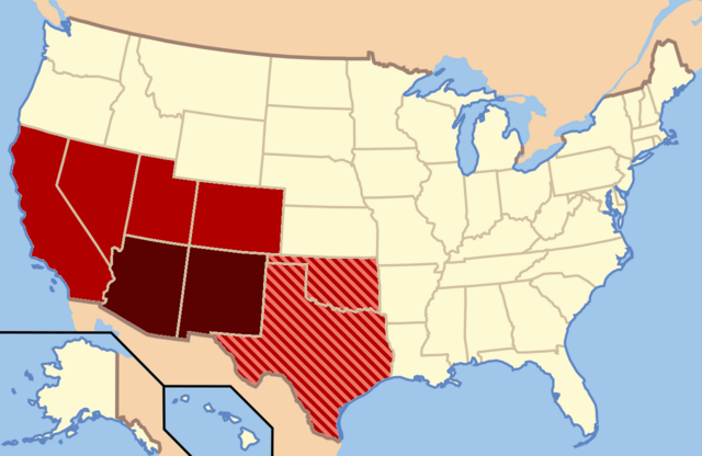
Dark Red: Almost always considered the Southwest |
| Tarih | |
| Kaynak | Yükleyenin kendi çalışması |
| Yazar | Secret Saturdays |
Lisanslama
| Ben, bu işin telif sahibi, bu işi kamu malı olarak yayınlıyorum. Bu dünya çapında geçerlidir. Bazı ülkelerde bu yasal olarak mümkün olmayabilir; öyleyse: Ben, bu işi herhangi bir amaç için, herhangi bir şart olmaksızın, yasalarca gerekli olmadıkça, herkesin kullanmasına izin veriyorum. |
Dosya geçmişi
Dosyanın herhangi bir zamandaki hâli için ilgili tarih/saat kısmına tıklayın.
| Tarih/Saat | Küçük resim | Boyutlar | Kullanıcı | Yorum | |
|---|---|---|---|---|---|
| güncel | 03.20, 9 Şubat 2022 | | 1.280 × 832 (199 KB) | Quackslikeaduck | Reverted to version as of 20:03, 25 August 2016 (UTC); Kansas is not considered part of the American Southwest, not even geographically. |
| 21.39, 31 Temmuz 2020 |  | 1.280 × 832 (159 KB) | Rubensbathsheba | Kansas may sometimes be considered part of the Southwest geographically. | |
| 20.03, 25 Ağustos 2016 |  | 1.280 × 832 (199 KB) | WClarke | Instead of using dark red, red, and blue stripes, this version uses dark red, red, and red stripes. Everything being red makes the map look more uniform. | |
| 22.53, 23 Temmuz 2009 |  | 572 × 371 (21 KB) | Secret Saturdays | {{Information |Description={{en|1=The Dark Red states mean they are almost always considered Southwest states, The light red states mean they are rarely considered Southwest states and the Blue States mean they are conisdered Southwest and Southern states |
Dosya kullanımı
Bu görüntü dosyasına bağlantısı olan sayfalar:
Küresel dosya kullanımı
Aşağıdaki diğer vikiler bu dosyayı kullanır:
- ar.wikipedia.org üzerinde kullanımı
- cs.wikipedia.org üzerinde kullanımı
- de.wikipedia.org üzerinde kullanımı
- en.wikipedia.org üzerinde kullanımı
- eo.wikipedia.org üzerinde kullanımı
- fy.wikipedia.org üzerinde kullanımı
- he.wikipedia.org üzerinde kullanımı
- id.wikipedia.org üzerinde kullanımı
- ko.wikipedia.org üzerinde kullanımı
- ru.wikipedia.org üzerinde kullanımı
- sv.wikipedia.org üzerinde kullanımı
- ur.wikipedia.org üzerinde kullanımı
- vi.wikipedia.org üzerinde kullanımı
- www.wikidata.org üzerinde kullanımı