
Dosya:Sir Bani Yas Island, United Arab Emirates.jpg

Bu önizlemenin boyutu: 398 × 599 piksel. Diğer çözünürlükler: 159 × 240 piksel | 319 × 480 piksel | 510 × 768 piksel | 680 × 1.024 piksel | 1.360 × 2.048 piksel | 4.016 × 6.048 piksel.
Tam çözünürlük ((4.016 × 6.048 piksel, dosya boyutu: 3,34 MB, MIME tipi: image/jpeg))
Bu dosya Wikimedia Commons'ta bulunmaktadır. Dosyanın açıklaması aşağıda gösterilmiştir. Commons, serbest/özgür telifli medya dosyalarının bulundurulduğu depodur. Siz de yardım edebilirsiniz. |
Özet
| Açıklama |
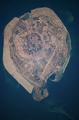
English: This astronaut photograph illustrates the varying character of surfaces on Sir Bani Yas. The central mountains of Jebel Wahid (image centre) mark the location of the Sir Bani Yas salt dome. The dome has breached the surface but exposed salt, primarily gypsum, is eroded, leaving a rugged, insoluble cap made of fragments of the overlaying sedimentary and volcanic rocks. Sand and silt derived from the Jebel Wahid and surrounding gravel-covered areas form beaches along the outer edge of the island. Tan graded areas along the western and north-eastern coast of the island (image bottom and image left) may be re-vegetated with additional plots or developed for other land uses. |
| Tarih | |
| Kaynak | NASA Earth Observatory |
| Yazar | Image taken by the NASA Expedition 22 crew. |
Image provided by the ISS Crew Earth Observations experiment and Image Science & Analysis Laboratory, Johnson Space Center.
Lisanslama
| Bu dosya NASA tarafından üretildiği için kamu malıdır. Aksi belirtilmediği sürece "NASA tarafından üretilen malzemenin telif hakkı olmadığı" NASA telif politikasında belirtilmiştir. (Bkz. Template:PD-USGov, NASA copyright policy page veya JPL Image Use Policy.) | ||
 |
Uyarılar:
|
| Annotations | This image is annotated: View the annotations at Commons |
Dosya geçmişi
Dosyanın herhangi bir zamandaki hâli için ilgili tarih/saat kısmına tıklayın.
| Tarih/Saat | Küçük resim | Boyutlar | Kullanıcı | Yorum | |
|---|---|---|---|---|---|
| güncel | 09.16, 29 Mart 2012 | | 4.016 × 6.048 (3,34 MB) | Rotatebot | Bot: Image rotated by 90° |
| 11.51, 15 Mart 2010 |  | 6.048 × 4.026 (3,35 MB) | Originalwana | {{Information |Description={{en|1=This astronaut photograph illustrates the varying character of surfaces on Sir Bani Yas. The central mountains of Jebel Wahid (image centre) mark the location of the Sir Bani Yas salt dome. The do |
Dosya kullanımı
Bu görüntü dosyasına bağlantısı olan sayfalar:
Küresel dosya kullanımı
Aşağıdaki diğer vikiler bu dosyayı kullanır:
- de.wikipedia.org üzerinde kullanımı
- en.wikipedia.org üzerinde kullanımı
- en.wikivoyage.org üzerinde kullanımı
- fa.wikipedia.org üzerinde kullanımı
- fi.wikipedia.org üzerinde kullanımı
- fr.wikipedia.org üzerinde kullanımı
- it.wikipedia.org üzerinde kullanımı
- ja.wikipedia.org üzerinde kullanımı
- pl.wikipedia.org üzerinde kullanımı
- www.wikidata.org üzerinde kullanımı