
Dosya:Roman provinces trajan.svg

Bu SVG dosyasının PNG önizlemesinin boyutu: 800 × 457 piksel. Diğer çözünürlükler: 320 × 183 piksel | 640 × 366 piksel | 1.024 × 585 piksel | 1.280 × 732 piksel | 2.560 × 1.463 piksel | 1.732 × 990 piksel.
Tam çözünürlük (SVG dosyası, sözde 1.732 × 990 piksel, dosya boyutu: 757 KB)
Bu dosya Wikimedia Commons'ta bulunmaktadır. Dosyanın açıklaması aşağıda gösterilmiştir. Commons, serbest/özgür telifli medya dosyalarının bulundurulduğu depodur. Siz de yardım edebilirsiniz. |
Özet
| Açıklama |
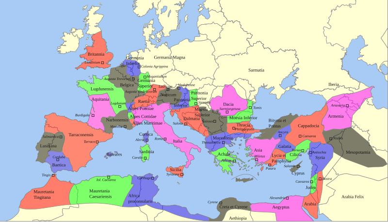
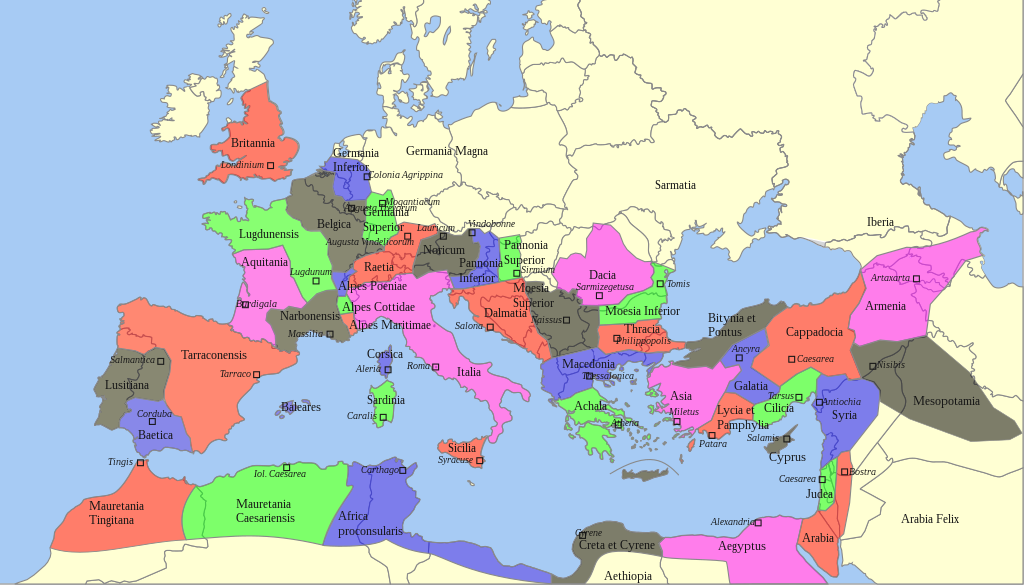
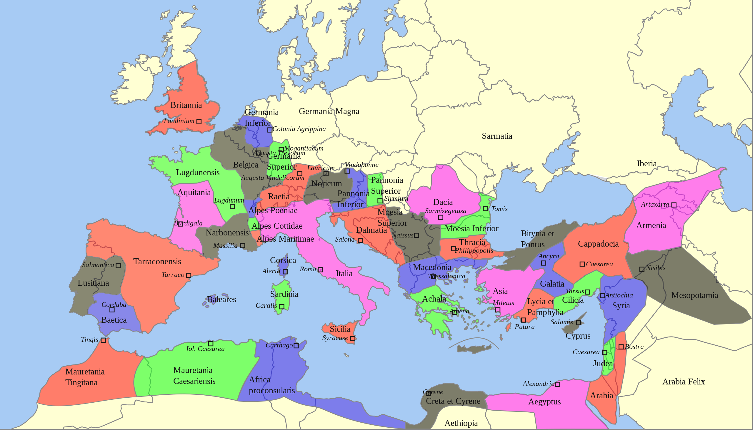
Deutsch: Territoriale Ausdehnung und provinziale Aufteilung des Römischen Reichs unter Trajan (117 n. Chr.) auf einer politischen Karte von 2013
English: Territorial extension and provincial division of the Roman Empire under Trajan (117 AD) on a political map of 2013 |
| Tarih | |
| Kaynak |
Bu dosya şu kaynaktan türetilmiştir: |
| Yazar |
|
| SVG gelişimi | Bu SVG kaynak kodu geçerlidir. Bu vektörel grafik CorelDRAW ile oluşturuldu. Bu SVG dosyası, gömülü metin editörü kullanarak kolayca çevirebilir. |
Lisanslama
Sebastian Wallroth, bu işin telif sahibi, burada işi aşağıdaki lisans altında yayımlıyor:
| Ben, bu işin telif sahibi, bu işi kamu malı olarak yayınlıyorum. Bu dünya çapında geçerlidir. Bazı ülkelerde bu yasal olarak mümkün olmayabilir; öyleyse: Ben, bu işi herhangi bir amaç için, herhangi bir şart olmaksızın, yasalarca gerekli olmadıkça, herkesin kullanmasına izin veriyorum. |
Orijinal yükleme günlüğü
This image is a derivative work of the following images:
- Roemischeprovinzentrajan.png licensed with PD-Demis
- 2007-06-29T05:49:35Z ThomasPusch 1218x730 (314106 Bytes) Name of "Mauretania Caesariensis'' (one "s" was missing) corrected - Name von "Mauretania Caesariensis" berichtigt - nomo de "Mauretania Caesariensis'' korektita
- 2005-11-27T11:10:02Z FJ-de 1218x730 (339534 Bytes) Karte ist erstellt von mir - Vorlage Demis http://www.demis.nl/wms/mapclip.htm
- Blank Map of Europe -w boundaries.svg licensed with Cc-by-sa-2.5,2.0,1.0, Cc-by-sa-3.0-migrated, GFDL
- 2008-06-19T01:33:53Z Roke 2045x1720 (724499 Bytes) more accurate version derived from [[:Image:Location European nation states.svg]] using same colours
- 2006-09-25T23:00:04Z Madman2001 0x0 (224972 Bytes) A blank map of Europe using Wikipedia standard colors in SVG format, based on [[:Image:BlankMap-Europe-v5.png]]. Note that the borders represent a second object "grouped" with the outline of Europe.
Uploaded with derivativeFX
Dosya geçmişi
Dosyanın herhangi bir zamandaki hâli için ilgili tarih/saat kısmına tıklayın.
| Tarih/Saat | Küçük resim | Boyutlar | Kullanıcı | Yorum | |
|---|---|---|---|---|---|
| güncel | 06.59, 22 Şubat 2022 | | 1.732 × 990 (757 KB) | Chaddy | Reverted to version as of 08:05, 17 May 2013 (UTC) this map is heavily broken since September |
| 17.00, 24 Eylül 2021 |  | 1.732 × 990 (576 KB) | Sebastian Wallroth | invalid element removed // Editing SVG source code using c:User:Rillke/SVGedit.js | |
| 16.55, 24 Eylül 2021 |  | 1.732 × 990 (576 KB) | Sebastian Wallroth | justified // Editing SVG source code using c:User:Rillke/SVGedit.js | |
| 16.52, 24 Eylül 2021 |  | 1.732 × 990 (577 KB) | Sebastian Wallroth | edited // Editing SVG source code using c:User:Rillke/SVGedit.js | |
| 16.48, 24 Eylül 2021 |  | 1.732 × 990 (579 KB) | Sebastian Wallroth | code reviewed // Editing SVG source code using c:User:Rillke/SVGedit.js | |
| 08.05, 17 Mayıs 2013 |  | 1.732 × 990 (757 KB) | Sebastian Wallroth | pure SVG | |
| 07.51, 17 Mayıs 2013 |  | 1.732 × 990 (756 KB) | Sebastian Wallroth | cut out | |
| 07.49, 17 Mayıs 2013 |  | 2.043 × 982 (679 KB) | Sebastian Wallroth | == {{int:filedesc}} == {{Information |Description={{de|Territoriale Ausdehnung und provinziale Aufteilung des Römischen Reichs unter Trajan (117 n. Chr.) auf einer politischen Karte von 2013}} {{en|Territorial extension and provincial division of the ... |
Dosya kullanımı
Bu görüntü dosyasına bağlanan sayfa yok.
Küresel dosya kullanımı
Aşağıdaki diğer vikiler bu dosyayı kullanır:
- en.wikipedia.org üzerinde kullanımı
- es.wikibooks.org üzerinde kullanımı
- sk.wikipedia.org üzerinde kullanımı