
Dosya:Roman expansion 264 BC Shepherd.jpg

Tam çözünürlük ((2.302 × 1.812 piksel, dosya boyutu: 873 KB, MIME tipi: image/jpeg))
Bu dosya Wikimedia Commons'ta bulunmaktadır. Dosyanın açıklaması aşağıda gösterilmiştir. Commons, serbest/özgür telifli medya dosyalarının bulundurulduğu depodur. Siz de yardım edebilirsiniz. |
This image was copied from wikipedia:de. The original description was:
| Açıklama |
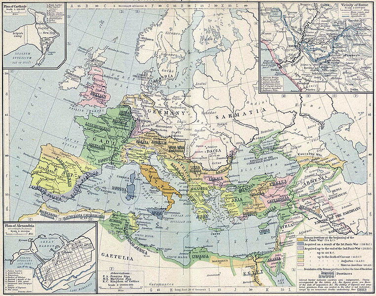
English: Roman territory, from the beginning of the 1st punic war (264 B.C.) to the death of Diocletian
Deutsch: Römisches Reich vom Beginn des 1. Punischen Kriegs (264 v.Chr.) bis zum Tod von Diokletian (312) im Historischen Atlas von William R. Shepherd (1923) |
| Tarih | 1923 |
| Kaynak | "Historical Atlas" by William R. Shepherd, New York, Henry Holt and Company |
| Yazar | William R. Shepherd |
| Diğer sürümler |
|
Bu çalışma ABD'de veya yazarın yaşamının sona ermiş olmasından 70 veya daha fazla süre geçtiğinde bu duruma uygun telif yasaları olan tüm ülkelerde kamu malıdır.
| |
| Bu dosyanın, tüm ilgili ve komşu haklar da dâhil olmak üzere, telif hakkı yasası kapsamında bilinen kısıtlamalardan arınmış olduğu belirlendi. | |
| date/time | username | edit summary |
|---|---|---|
| 18:08, 21. Feb 2005 | Benowar | ("Historical Atlas" by William R. Shepherd, New York, Henry Holt and Company, 1923 PUBLIC DOMAIN) |
Dosya geçmişi
Dosyanın herhangi bir zamandaki hâli için ilgili tarih/saat kısmına tıklayın.
| Tarih/Saat | Küçük resim | Boyutlar | Kullanıcı | Yorum | |
|---|---|---|---|---|---|
| güncel | 17.08, 18 Nisan 2006 | | 2.302 × 1.812 (873 KB) | Crux | verbesserte Version |
| 16.53, 18 Nisan 2006 |  | 2.302 × 1.812 (767 KB) | Crux | This image was copied from wikipedia:de. The original description was: {{Information| |Description=Roman territory at the beginning of the 1st punic war (264 B.C.) |Source="Historical Atlas" by William R. Shepherd, New York, Henry Holt and Company |Date= |
Dosya kullanımı
Bu görüntü dosyasına bağlanan sayfa yok.
Küresel dosya kullanımı
Aşağıdaki diğer vikiler bu dosyayı kullanır:
- ast.wikipedia.org üzerinde kullanımı
- ba.wikipedia.org üzerinde kullanımı
- bn.wikipedia.org üzerinde kullanımı
- br.wikipedia.org üzerinde kullanımı
- ca.wikipedia.org üzerinde kullanımı
- de.wikipedia.org üzerinde kullanımı
- de.wikibooks.org üzerinde kullanımı
- en.wikipedia.org üzerinde kullanımı
- es.wikipedia.org üzerinde kullanımı
- fr.wikipedia.org üzerinde kullanımı
- fy.wikipedia.org üzerinde kullanımı
- it.wikipedia.org üzerinde kullanımı
- it.wikibooks.org üzerinde kullanımı
- lv.wikipedia.org üzerinde kullanımı
- mk.wikipedia.org üzerinde kullanımı
- mwl.wikipedia.org üzerinde kullanımı
- pnb.wikipedia.org üzerinde kullanımı
- pt.wikipedia.org üzerinde kullanımı
- ru.wikipedia.org üzerinde kullanımı
- sa.wikipedia.org üzerinde kullanımı
- skr.wikipedia.org üzerinde kullanımı
- sk.wikipedia.org üzerinde kullanımı
- sl.wikipedia.org üzerinde kullanımı
- sq.wikipedia.org üzerinde kullanımı
- ur.wikipedia.org üzerinde kullanımı
- vi.wikipedia.org üzerinde kullanımı
- zh.wikipedia.org üzerinde kullanımı