
Dosya:Qaidam-basin-china.jpg

Bu önizlemenin boyutu: 600 × 600 piksel. Diğer çözünürlükler: 240 × 240 piksel | 480 × 480 piksel | 768 × 768 piksel | 1.024 × 1.024 piksel | 1.280 × 1.280 piksel.
Tam çözünürlük ((1.280 × 1.280 piksel, dosya boyutu: 1,16 MB, MIME tipi: image/jpeg))
Bu dosya Wikimedia Commons'ta bulunmaktadır. Dosyanın açıklaması aşağıda gösterilmiştir. Commons, serbest/özgür telifli medya dosyalarının bulundurulduğu depodur. Siz de yardım edebilirsiniz. |
Özet
| Açıklama |
Deutsch: STS040-613-011 Qaidambecken, China, Juni 1991
English: Image Caption: STS040-613-011 Qaidam Basin, China June 1991
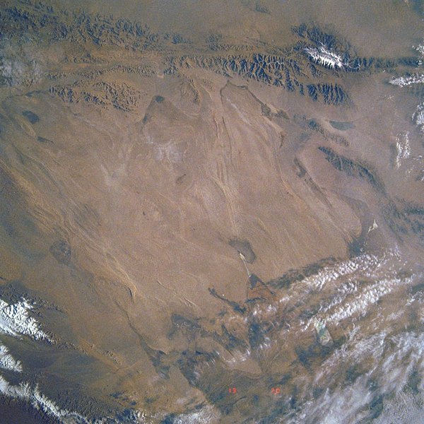
This mostly east-looking view [here rotated to place north at the top] shows the Qaidam Basin. Located in the Northern Tibetan Plateau, the Qaidam Basin sets between two branches of the Kunlun Mountains. To the north (left edge) are the Altun Mountains and to the south (right edge) are the Qimantag Mountains. The arid basin is 350 miles (560 km) long and 100 miles (160 km) wide. A salt marsh occupies most of the basin. Oil fields and refineries are located in the west part (bottom center) of the basin. Iron ore is mined in the southern part of the basin. Coal deposits have been found in the Qaidam Basin. Cooler climate crops such as wheat, highland barley, millet, and potatoes are grown during the short, cool summer months. Español: STS040-613-011 Cuenca de Qaidam, China, Junio de 1991 |
||||
| Tarih | |||||
| Kaynak |
https://eol.jsc.nasa.gov/SearchPhotos/photo.pl?mission=STS040&roll=613&frame=11 (original uploader information: http://eol.jsc.nasa.gov/sseop/efs/lores.pl?PHOTO=STS040-613-11) |
||||
| Yazar | NASA | ||||
| Photo center point |
|
Lisanslama
| Bu dosya NASA tarafından üretildiği için kamu malıdır. Aksi belirtilmediği sürece "NASA tarafından üretilen malzemenin telif hakkı olmadığı" NASA telif politikasında belirtilmiştir. (Bkz. Template:PD-USGov, NASA copyright policy page veya JPL Image Use Policy.) | ||
 |
Uyarılar:
|
Orijinal yükleme günlüğü
en.wikipedia üzerinden Commons'a Quadell tarafından CommonsHelper kullanarak transfer edildi.
Dosyanın orjinal açıklama sayfası burada bulunmaktadır. Aşağıdaki tüm kullanıcı adları için en.wikipedia bakın.
- 2008-02-06 02:49 Mattisse 640×640× (385252 bytes) {{Information |Description=Quaidam Basin, China |Source=http://eol.jsc.nasa.gov/sseop/efs/lores.pl?PHOTO=STS040-613-11 |Date=2008-02-05 |Location=Quaidam Basin, China |Author=NASA |Permission= |other_versions= }}
| Annotations | This image is annotated: View the annotations at Commons |
Dosya geçmişi
Dosyanın herhangi bir zamandaki hâli için ilgili tarih/saat kısmına tıklayın.
| Tarih/Saat | Küçük resim | Boyutlar | Kullanıcı | Yorum | |
|---|---|---|---|---|---|
| güncel | 08.18, 7 Ağustos 2019 | | 1.280 × 1.280 (1,16 MB) | LlywelynII | Reverted to version as of 08:17, 7 August 2019 (UTC) STOP ROTATING THIS |
| 08.18, 7 Ağustos 2019 |  | 640 × 640 (404 KB) | LlywelynII | Reverted to version as of 08:12, 7 August 2019 (UTC) testing | |
| 08.17, 7 Ağustos 2019 |  | 1.280 × 1.280 (1,16 MB) | LlywelynII | let's try this again... | |
| 08.12, 7 Ağustos 2019 |  | 640 × 640 (404 KB) | LlywelynII | North at top | |
| 19.34, 7 Eylül 2011 |  | 640 × 640 (376 KB) | File Upload Bot (Magnus Manske) | {{BotMoveToCommons|en.wikipedia|year={{subst:CURRENTYEAR}}|month={{subst:CURRENTMONTHNAME}}|day={{subst:CURRENTDAY}}}} {{Information |Description={{en|Qaidam Basin, China}} |Source=Transferred from [http://en.wikipedia.org en.wikipedia]; transferred to C |
Dosya kullanımı
Bu görüntü dosyasına bağlantısı olan sayfalar:
Küresel dosya kullanımı
Aşağıdaki diğer vikiler bu dosyayı kullanır:
- az.wikipedia.org üzerinde kullanımı
- de.wikipedia.org üzerinde kullanımı
- en.wikipedia.org üzerinde kullanımı
- es.wikipedia.org üzerinde kullanımı
- hy.wikipedia.org üzerinde kullanımı
- id.wikipedia.org üzerinde kullanımı
- no.wikipedia.org üzerinde kullanımı
- ru.wikipedia.org üzerinde kullanımı
- sl.wikipedia.org üzerinde kullanımı
- sr.wikipedia.org üzerinde kullanımı
- sv.wikipedia.org üzerinde kullanımı
- vi.wikipedia.org üzerinde kullanımı
- zh-yue.wikipedia.org üzerinde kullanımı