
Dosya:Peters projection, date line in Bering strait.svg

Bu SVG dosyasının PNG önizlemesinin boyutu: 800 × 545 piksel. Diğer çözünürlükler: 320 × 218 piksel | 640 × 436 piksel | 1.024 × 697 piksel | 1.280 × 871 piksel | 2.560 × 1.743 piksel | 1.613 × 1.098 piksel.
Tam çözünürlük (SVG dosyası, sözde 1.613 × 1.098 piksel, dosya boyutu: 808 KB)
Bu dosya Wikimedia Commons'ta bulunmaktadır. Dosyanın açıklaması aşağıda gösterilmiştir. Commons, serbest/özgür telifli medya dosyalarının bulundurulduğu depodur. Siz de yardım edebilirsiniz. |
Özet
| Açıklama |
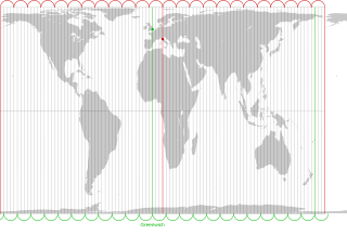
English: The Peters projection with corrected date line in the Bering strait, 168°45' West of Greenwich, proposed by Arno Peters. On his world map the easternmost part of Russia is not displayed left of Alaska, as it is usually done. Instead, it is on the right with the rest of Russia. The antipode of Peters' corrected date line is the meridian, 11° 15' East of Greenwich, traversing the city center of Florence in Italy.
The drawn out 96 meridians mark quarters of the hour. Green: Longitude of Greenwich and the old date line. Red: Longitude of Florence and Peters date line.Deutsch: Die Peters-Projektion mit korrigierter Datumsgrenze in der Beringstraße, 168°45' westlich von Greenwich. Diese wurde von Arno Peters vorgeschlagen, damit die Ostspitze Russlands auf der Weltkarte nicht wie sonst üblich abgeschnitten und links von Alaska dargestellt wird.
Die Antipode zu Peters' korrigierter Datumsgrenze ist der Meridian 11° 15' östlich von Greenwich, der durch das Stadtzentrum von Florenz in Italien verläuft. Die ausgezogenen 96 Meridiane markieren Viertelstunden. Grün: Länge von Greenwich und alte Datumsgrenze. Rot. Länge von Florenz und korrigierte Datumsgrenze in der Beringstraße. |
| Tarih | |
| Kaynak | Own work by uploader. On this Peters map you can see the corrected date line |
| Yazar | Watchduck |
| Diğer sürümler | Bu dosyanın türev çalışmaları: Peters projection, blank.svg |
Lisanslama
| Ben, bu işin telif sahibi, bu işi kamu malı olarak yayınlıyorum. Bu dünya çapında geçerlidir. Bazı ülkelerde bu yasal olarak mümkün olmayabilir; öyleyse: Ben, bu işi herhangi bir amaç için, herhangi bir şart olmaksızın, yasalarca gerekli olmadıkça, herkesin kullanmasına izin veriyorum. |
Dosya geçmişi
Dosyanın herhangi bir zamandaki hâli için ilgili tarih/saat kısmına tıklayın.
| Tarih/Saat | Küçük resim | Boyutlar | Kullanıcı | Yorum | |
|---|---|---|---|---|---|
| güncel | 22.27, 13 Mart 2009 | | 1.613 × 1.098 (808 KB) | Watchduck | |
| 17.11, 13 Mart 2009 |  | 1.613 × 1.098 (1,85 MB) | Watchduck | ||
| 15.54, 13 Mart 2009 |  | 1.613 × 1.190 (1,85 MB) | Watchduck | {{Information |Description={{en|1=The Peters projection with corrected date line in the Bering strait, 168°45' West of Greenwich, proposed by Arno Peters not to |
Dosya kullanımı
Bu görüntü dosyasına bağlantısı olan sayfalar:
Küresel dosya kullanımı
Aşağıdaki diğer vikiler bu dosyayı kullanır:
- ca.wikipedia.org üzerinde kullanımı
- en.wikipedia.org üzerinde kullanımı
- eo.wikipedia.org üzerinde kullanımı
- es.wikipedia.org üzerinde kullanımı
- fi.wikipedia.org üzerinde kullanımı
- fr.wikipedia.org üzerinde kullanımı
- he.wikipedia.org üzerinde kullanımı
- id.wikipedia.org üzerinde kullanımı
- it.wikipedia.org üzerinde kullanımı
- la.wikipedia.org üzerinde kullanımı
- nds-nl.wikipedia.org üzerinde kullanımı
- oc.wikipedia.org üzerinde kullanımı
- pt.wikipedia.org üzerinde kullanımı
- ru.wikipedia.org üzerinde kullanımı
- sq.wikipedia.org üzerinde kullanımı
- zh.wikipedia.org üzerinde kullanımı