
Dosya:PIA19080-MarsRoverCuriosity-AncientGaleLake-Simulated-20141208.jpg

Tam çözünürlük ((2.560 × 1.600 piksel, dosya boyutu: 1,05 MB, MIME tipi: image/jpeg))
Bu dosya Wikimedia Commons'ta bulunmaktadır. Dosyanın açıklaması aşağıda gösterilmiştir. Commons, serbest/özgür telifli medya dosyalarının bulundurulduğu depodur. Siz de yardım edebilirsiniz. |
Özet
| Açıklama |
English: December 8, 2014
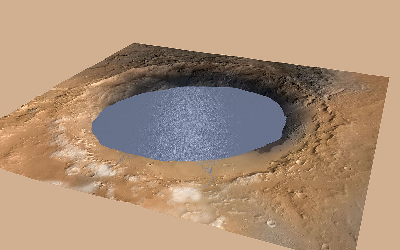
Simulated View of Gale Crater Lake on Mars http://mars.jpl.nasa.gov/msl/multimedia/images/?ImageID=6875 This simulation depicts a lake partially filling Mars' Gale Crater, receiving runoff from snow melting on the crater's rim. Evidence that NASA's Curiosity rover has found of ancient streams, deltas and lakes suggests the crater held a lake such as this more than three billion years ago. This illustration depicts a lake of water partially filling Mars' Gale Crater, receiving runoff from snow melting on the crater's northern rim. Evidence of ancient streams, deltas and lakes that NASA's Curiosity Mars rover mission has found in the patterns of sedimentary deposits in Gale Crater suggests the crater held a lake such as this more than three billion years ago, filling and drying in multiple cycles over tens of millions of years. Gale Crater is 96 miles (154 kilometers) in diameter. This view is looking toward the southeast. The land surface in this illustration is the area's modern shape. Three billion years ago, the rim would have been higher and less eroded. A large layered mountain, Mount Sharp, now stands in the middle of Gale Crater. Accumulation of sediments in lakes, deltas, streams and wind-blown deposits is proposed to have formed the layers making up the lower portion of the mountain. When the crater first held a lake, it might have had central peak, much smaller than Mount Sharp, formed as a rebound from the impact that excavated the crater. Such a peak might have appeared as an island in the lake. This illustration incorporates portions of a simulated oblique view of Gale Crater (http://photojournal.jpl.nasa.gov/catalog/PIA15292) based on elevation data from the High Resolution Stereo Camera on the European Space Agency's Mars Express orbiter, image data from the Context Camera on NASA's Mars Reconnaissance Orbiter, and color information from Viking Orbiter imagery. The appearance of snow is added as part of the simulation of conditions from billions of years ago. The lake is depicted filling the crater approximately to the elevation where Curiosity found lakebed sediments in the "Pahrump Hills" outcrop at the base of Mount Sharp. For more information about the Mars Science Laboratory mission and the mission's Curiosity rover, visit http://www.nasa.gov/msl and http://mars.nasa.gov/msl/. |
| Tarih | |
| Kaynak | http://mars.jpl.nasa.gov/msl/images/mars-rover-curiosity-Meyer-Vasavada-Gale-Lake-pia19080-full.jpg |
| Yazar | NASA/JPL-Caltech/ESA/DLR/FU Berlin/MSSS |
Lisanslama
| Bu dosya NASA tarafından üretildiği için kamu malıdır. Aksi belirtilmediği sürece "NASA tarafından üretilen malzemenin telif hakkı olmadığı" NASA telif politikasında belirtilmiştir. (Bkz. Template:PD-USGov, NASA copyright policy page veya JPL Image Use Policy.) | ||
 |
Uyarılar:
|
Dosya geçmişi
Dosyanın herhangi bir zamandaki hâli için ilgili tarih/saat kısmına tıklayın.
| Tarih/Saat | Küçük resim | Boyutlar | Kullanıcı | Yorum | |
|---|---|---|---|---|---|
| güncel | 20.24, 15 Aralık 2014 | | 2.560 × 1.600 (1,05 MB) | Drbogdan | User created page with UploadWizard |
Dosya kullanımı
Bu görüntü dosyasına bağlantısı olan sayfalar:
Küresel dosya kullanımı
Aşağıdaki diğer vikiler bu dosyayı kullanır:
- el.wikipedia.org üzerinde kullanımı
- en.wikipedia.org üzerinde kullanımı
- en.wikinews.org üzerinde kullanımı
- es.wikipedia.org üzerinde kullanımı
- it.wikipedia.org üzerinde kullanımı
- ja.wikipedia.org üzerinde kullanımı
- pnb.wikipedia.org üzerinde kullanımı
- uk.wikipedia.org üzerinde kullanımı
- ur.wikipedia.org üzerinde kullanımı
- zh.wikipedia.org üzerinde kullanımı