
Dosya:NCyprus districts named.png

Daha yüksek çözünürlüğe sahip sürüm bulunmamaktadır.
NCyprus_districts_named.png ((600 × 365 piksel, dosya boyutu: 47 KB, MIME tipi: image/png))
Bu dosya Wikimedia Commons'ta bulunmaktadır. Dosyanın açıklaması aşağıda gösterilmiştir. Commons, serbest/özgür telifli medya dosyalarının bulundurulduğu depodur. Siz de yardım edebilirsiniz. |
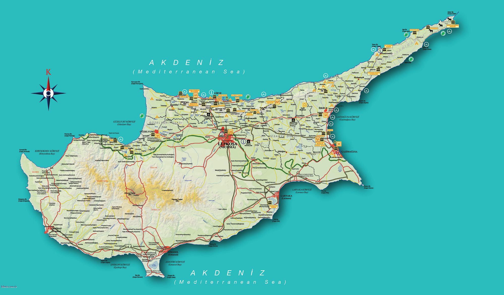
| Açıklama | Map of the districts of Cyprus, with English annotations, and showing the Turkish Republic of Northern Cyprus, United Kingdom Sovereign Base Areas, and United Nations buffer zone. The TRNC section illustrates the current de facto district boundaries following this map as a guide. The northern districts are labelled in Turkish. | |||
| Tarih | (UTC) | |||
| Kaynak | ||||
| Yazar |
|
|||
| Diğer sürümler |
|


Ben, bu işin telif sahibi, burada işi aşağıdaki lisanslar altında yayımlıyorum:
Bu dosya Creative Commons Atıf-Benzer Paylaşım 2.5 Genel, 2.0 Genel ve 1.0 Genel lisansları ile lisanslanmıştır.
- Şu seçeneklerde özgürsünüz:
- paylaşım – eser paylaşımı, dağıtımı ve iletimi
- içeriği değiştirip uyarlama – eser adaptasyonu
- Aşağıdaki koşullar geçerli olacaktır:
- atıf – Esere yazar veya lisans sahibi tarafından belirtilen (ancak sizi ya da eseri kullanımınızı desteklediklerini ileri sürmeyecek bir) şekilde atıfta bulunmalısınız.
- benzer paylaşım – Maddeyi yeniden karıştırır, dönüştürür veya inşa ederseniz, katkılarınızı orijinal olarak aynı veya uyumlu lisans altında dağıtmanız gerekir.

|
Bu belgenin GNU Özgür Belgeleme Lisansı, Sürüm 1.2 veya Özgür Yazılım Vakfı tarafından yayımlanan sonraki herhangi bir sürüm şartları altında bu belgenin kopyalanması, dağıtılması ve/veya değiştirilmesi için izin verilmiştir;
Değişmeyen Bölümler, Ön Kapak Metinleri ve Arka Kapak Metinleri yoktur. Lisansın bir kopyası GNU Özgür Belgeleme Lisansı sayfasında yer almaktadır. |
| Bu dosya, Creative Commons Atıf-Benzer Paylaşım 3.0 Taşınmamış lisansı ile lisanslanmıştır | ||
| ||
| Bu lisanslama etiketi, dosyaya GFDL lisanslama güncelleştirmenin bir parçası olarak eklenmiştir. |
İstediğiniz lisansı seçebilirsiniz.
Orijinal yükleme günlüğü
This image is a derivative work of the following images:
- Image:Cyprus_districts_named.png licensed with Cc-by-sa-2.5,2.0,1.0, GFDL
- 2007-08-13T14:28:15Z Lexicon 600x365 (22511 Bytes) Reverted to earlier revision
- 2007-08-13T14:28:03Z Lexicon 600x365 (55202 Bytes) buffer zone and SBA colours flipped, since buffer zone is called the "Green Line"
- 2005-06-30T06:07:58Z Golbez 600x365 (22511 Bytes) Got Dhekelia wrong again. Final version unless others have comments.
- 2005-06-28T02:04:32Z Golbez 600x365 (22795 Bytes) Updated again, final version for now, cleaned up text and the Dhekelia area.
- 2005-06-27T17:51:02Z Golbez 600x365 (20527 Bytes) Fixed a color
- 2005-06-27T17:44:36Z Golbez 600x365 (20529 Bytes) Updated map with different color for north and south, and enclaves in Dhekelia.
- 2005-06-27T09:48:54Z Golbez 600x365 (19121 Bytes) Map of the districts of [[Cyprus]] Source: Made by [[User:Golbez]]. {{cc-by-sa-2.0}} [[Category:Maps of Cyprus]]\
Uploaded with derivativeFX
Dosya geçmişi
Dosyanın herhangi bir zamandaki hâli için ilgili tarih/saat kısmına tıklayın.
| Tarih/Saat | Küçük resim | Boyutlar | Kullanıcı | Yorum | |
|---|---|---|---|---|---|
| güncel | 13.34, 18 Eylül 2008 | | 600 × 365 (47 KB) | QuartierLatin1968 | {{Information |Description=Map of the districts of Cyprus, with English annotations, and showing the Turkish Republic of Northern Cyprus, United Kingdom Sovereign Base Areas, and United Nations buffer zone. The TRNC section illustrates the current ''de fa |
Dosya kullanımı
Bu görüntü dosyasına bağlantısı olan sayfalar:
Küresel dosya kullanımı
Aşağıdaki diğer vikiler bu dosyayı kullanır:
- am.wikipedia.org üzerinde kullanımı
- ar.wikipedia.org üzerinde kullanımı
- arz.wikipedia.org üzerinde kullanımı
- ba.wikipedia.org üzerinde kullanımı
- be.wikipedia.org üzerinde kullanımı
- bg.wikipedia.org üzerinde kullanımı
- de.wikipedia.org üzerinde kullanımı
- el.wikipedia.org üzerinde kullanımı
- en.wikipedia.org üzerinde kullanımı
- fr.wikipedia.org üzerinde kullanımı
- gl.wikipedia.org üzerinde kullanımı
- it.wikivoyage.org üzerinde kullanımı
- la.wikipedia.org üzerinde kullanımı
- mk.wikipedia.org üzerinde kullanımı
- mrj.wikipedia.org üzerinde kullanımı
- pt.wikipedia.org üzerinde kullanımı
- ru.wikipedia.org üzerinde kullanımı
- sc.wikipedia.org üzerinde kullanımı
- simple.wikipedia.org üzerinde kullanımı
- sk.wikipedia.org üzerinde kullanımı
- sr.wikipedia.org üzerinde kullanımı
- sv.wikipedia.org üzerinde kullanımı
- tg.wikipedia.org üzerinde kullanımı
- uk.wikipedia.org üzerinde kullanımı
- vi.wikipedia.org üzerinde kullanımı
- zh.wikipedia.org üzerinde kullanımı