
Dosya:MH370 SearchAreaMap June 2014.jpg
Tam çözünürlük ((3.508 × 2.480 piksel, dosya boyutu: 5,47 MB, MIME tipi: image/jpeg))
Bu dosya Wikimedia Commons'ta bulunmaktadır. Dosyanın açıklaması aşağıda gösterilmiştir. Commons, serbest/özgür telifli medya dosyalarının bulundurulduğu depodur. Siz de yardım edebilirsiniz. |
Özet
| Açıklama |
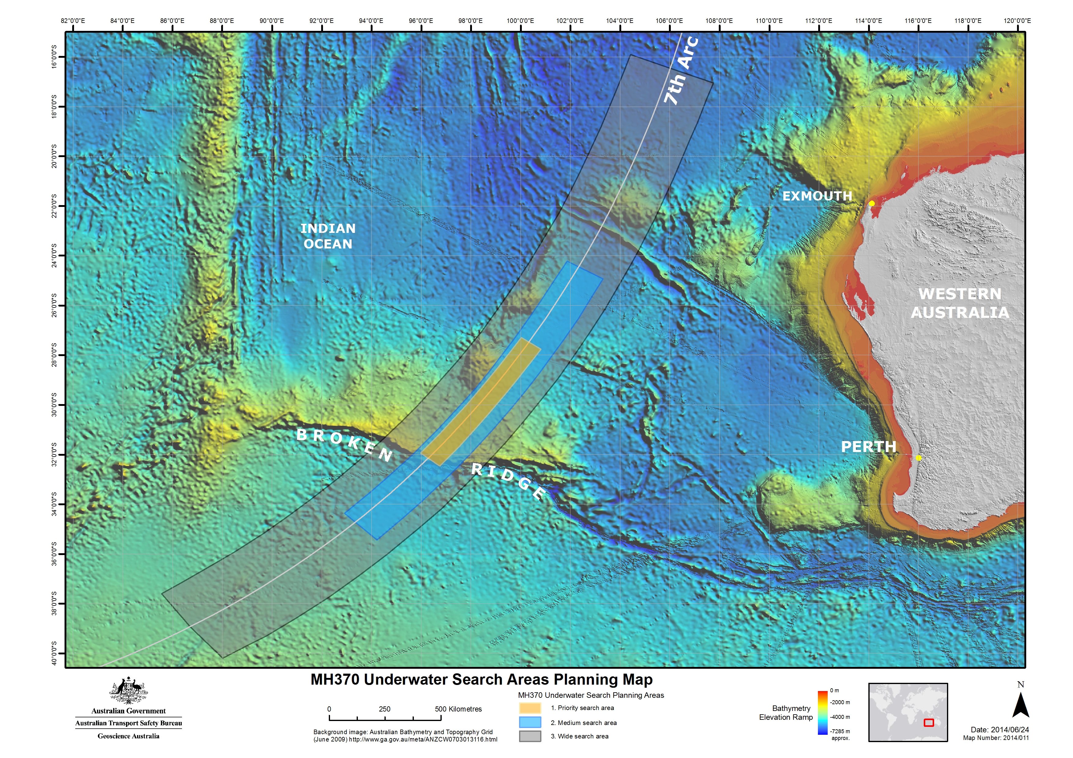
English: Map of the region to be searched for Malaysia Airlines Flight 370 announced 26 June 2014. The searching of this region is expected to begin in August 2014 and take up to 12 months to complete. Note on the background image some tracks of higher resolution bathymetric data, which had been obtained from soundings by passing ships. |
| Tarih | |
| Kaynak | [1] |
| Yazar | Australian Transport Safety Bureau |
| İzin (Bu dosyanın tekrar kullanımı) |
Note:All three versions uploaded are identical, which includes the date (2014/06/24) and "Map number" (2014/011). The only difference is the pixel size. The third version (4 October 2014) uploaded is from the ATSB website, which states on the "Copyright" page: "Apart from the Coat of Arms, the ATSB logo, photos and graphics in which a third party has copyright, our investigation reports are licensed under the Creative Commons Attribution 3.0 Australia Licence." The second version (30 July 2014) uploaded was extracted from a report by the ATSB which states (pg. 2): "With the exception of the Coat of Arms, ATSB logo, and photos and graphics in which a third party holds copyright, this publication is licensed under a Creative Commons Attribution 3.0 Australia license." The background bathymetric image comes from here, listing "Access constraints: No restrictions". Per the Geoscience Australia website: "Unless otherwise noted, all Geoscience Australia material on this website is licensed under the Creative Commons Attribution 3.0 Australia Licence." The original version (27 June 2014) was obtained from JACC (a link from this press release) because I was unable to figure out, at the time, how to extract the image from the ATSB report (PDF). The JACC claimed copyright to content on its website, but the image was seemingly identical (visual appearance & id number: "Map 2014/011") to the map in the ATSB report, which was later uploaded. |
Lisanslama
- Şu seçeneklerde özgürsünüz:
- paylaşım – eser paylaşımı, dağıtımı ve iletimi
- içeriği değiştirip uyarlama – eser adaptasyonu
- Aşağıdaki koşullar geçerli olacaktır:
- atıf – Esere yazar veya lisans sahibi tarafından belirtilen (ancak sizi ya da eseri kullanımınızı desteklediklerini ileri sürmeyecek bir) şekilde atıfta bulunmalısınız.

Dosya geçmişi
Dosyanın herhangi bir zamandaki hâli için ilgili tarih/saat kısmına tıklayın.
| Tarih/Saat | Küçük resim | Boyutlar | Kullanıcı | Yorum | |
|---|---|---|---|---|---|
| güncel | 03.59, 4 Ekim 2014 | | 3.508 × 2.480 (5,47 MB) | AHeneen | Higher resolution obtained from ATSB website. |
| 01.17, 30 Temmuz 2014 |  | 1.514 × 1.070 (299 KB) | AHeneen | Higher resolution image. Extracted from ATSB report. | |
| 02.25, 27 Haziran 2014 |  | 1.024 × 724 (436 KB) | AHeneen | User created page with UploadWizard |
Dosya kullanımı
Bu görüntü dosyasına bağlantısı olan sayfalar:
Küresel dosya kullanımı
Aşağıdaki diğer vikiler bu dosyayı kullanır:
- de.wikipedia.org üzerinde kullanımı
- en.wikipedia.org üzerinde kullanımı
- vi.wikipedia.org üzerinde kullanımı
- www.wikidata.org üzerinde kullanımı