
Dosya:Great Basin National Park map 2007.04.png

Bu önizlemenin boyutu: 679 × 600 piksel. Diğer çözünürlükler: 272 × 240 piksel | 543 × 480 piksel | 869 × 768 piksel | 1.159 × 1.024 piksel | 1.647 × 1.455 piksel.
Tam çözünürlük ((1.647 × 1.455 piksel, dosya boyutu: 649 KB, MIME tipi: image/png))
Bu dosya Wikimedia Commons'ta bulunmaktadır. Dosyanın açıklaması aşağıda gösterilmiştir. Commons, serbest/özgür telifli medya dosyalarının bulundurulduğu depodur. Siz de yardım edebilirsiniz. |
Özet
| Açıklama |
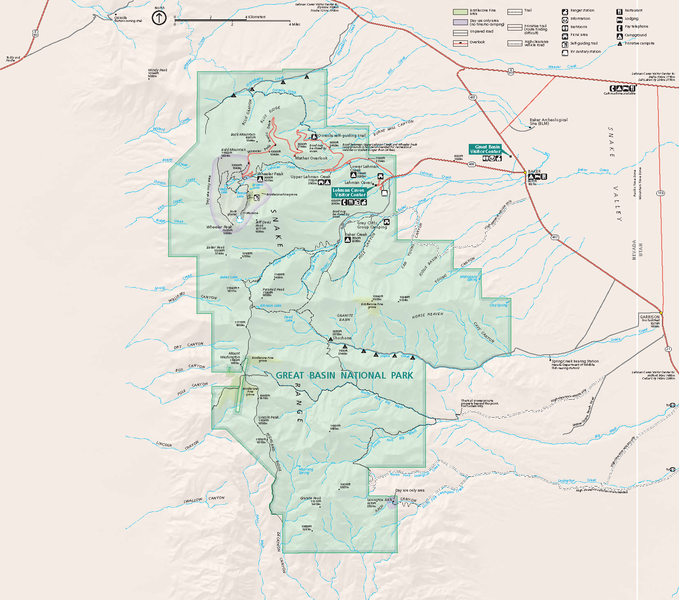
Official National Park Service map — of Great Basin National Park.
GRBAmap1.pdf |
| Tarih | |
| Kaynak | [1] |
| Yazar | National Park Service, Harpers Ferry Center |
| İzin (Bu dosyanın tekrar kullanımı) |
"The maps at this site are in the public domain. You may use National Park Service maps provided that you agree to assume complete legal responsibility for problems resulting from their use. Although National Park Service maps are easy to modify, understand that modifications can adversely alter the meaning and accuracy of the original data. Law prohibits you from using the National Park Service seal or claiming National Park Service endorsement with downloaded maps." [2] |
Lisanslama
| This image or media file contains material based on a work of a National Park Service employee, created as part of that person's official duties. As a work of the U.S. federal government, such work is in the public domain in the United States. See the NPS website and NPS copyright policy for more information. |
Dosya geçmişi
Dosyanın herhangi bir zamandaki hâli için ilgili tarih/saat kısmına tıklayın.
| Tarih/Saat | Küçük resim | Boyutlar | Kullanıcı | Yorum | |
|---|---|---|---|---|---|
| güncel | 04.48, 14 Ekim 2007 | | 1.647 × 1.455 (649 KB) | Werewombat | == Summary == {{Information |Description = Official National Park Service map of en:Great Basin National Park, en:Nevada. Converted from PDF using Adobe Acrobat 7.0 Professional. O |
Dosya kullanımı
Bu görüntü dosyasına bağlantısı olan sayfalar:
Küresel dosya kullanımı
Aşağıdaki diğer vikiler bu dosyayı kullanır:
- cs.wikipedia.org üzerinde kullanımı
- da.wikipedia.org üzerinde kullanımı
- fr.wikipedia.org üzerinde kullanımı
- he.wikipedia.org üzerinde kullanımı
- hu.wikipedia.org üzerinde kullanımı
- is.wikipedia.org üzerinde kullanımı
- nl.wikipedia.org üzerinde kullanımı
- pl.wikipedia.org üzerinde kullanımı
- ru.wikipedia.org üzerinde kullanımı