
Dosya:Golan heights rel89B.jpg

Bu önizlemenin boyutu: 468 × 599 piksel. Diğer çözünürlükler: 187 × 240 piksel | 375 × 480 piksel | 1.022 × 1.308 piksel.
Tam çözünürlük ((1.022 × 1.308 piksel, dosya boyutu: 231 KB, MIME tipi: image/jpeg))
Bu dosya Wikimedia Commons'ta bulunmaktadır. Dosyanın açıklaması aşağıda gösterilmiştir. Commons, serbest/özgür telifli medya dosyalarının bulundurulduğu depodur. Siz de yardım edebilirsiniz. |
Özet
| Açıklama |
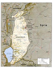
English: I created this image myself, by modifying the existing Image:Golan_heights_rel89A.jpg, which was itself a modified version of a modified CIA (and hence public domain) Image:Golan_92.jpg. Previous modifications were done to provide a map that was impartial about the contentious issue of which country owns the Golan Heights. The previous modifications were effective in creating a neutral map by removing the names "Syria" and "Israel" from the contentious territory and left only the label "Golan Heights". The present modification was intended solely to restore the names and locations of villages that were included on the original CIA map but had been (inadvertently) moved or erased by relocating the country titles. Due to the recurrent conflict involving villages and settlements within the Golan Heights, I feel that it is important to retain the locations on the map. As with the earlier modifications of this file, I hope that this modification will be seen as a fair compromise that also maintains the cartographical accuracy of map. I make no copyright claim on my modification; its copyright status is the same as its source. dp_roberson 15:44, 21 October 2007 (UTC) |
| Tarih | 21 Eylül 2007 (original upload date) |
| Kaynak | en.wikipedia üzerinden Commons'a transfer edildi. |
| Yazar | Dp roberson at İngilizce Vikipedi |
Lisanslama
| Bu iş yazarı Dp roberson at İngilizce Vikipedi tarafından kamu malı olarak yayınlanmıştır. Bu dünya çapında geçerlidir. Bazı ülkelerde bu yasal olarak mümkün olmayabilir; öyleyse: Dp roberson, bu işi herhangi bir amaç için, herhangi bir şart olmaksızın, yasalarca gerekli olmadıkça, herkesin kullanmasına izin veriyor. |
Orijinal yükleme günlüğü
Dosyanın orjinal açıklama sayfası burada bulunmaktadır. Aşağıdaki tüm kullanıcı adları için en.wikipedia bakın.
- 2008-12-29 03:13 كهيعص 1022×1308× (236080 bytes) added 4 villages to the map
- 2007-09-21 15:45 Dp roberson 1022×1308× (226330 bytes) I created this image myself, by modifying the existing Image:Golan_heights_rel89A.jpg, which was itself a modified version of a modified CIA (and hence public domain) Image:Golan_92.jpg. Previous modifications were done to provide a map that was impartia
Dosya geçmişi
Dosyanın herhangi bir zamandaki hâli için ilgili tarih/saat kısmına tıklayın.
| Tarih/Saat | Küçük resim | Boyutlar | Kullanıcı | Yorum | |
|---|---|---|---|---|---|
| güncel | 04.56, 27 Ocak 2015 | | 1.022 × 1.308 (231 KB) | Magog the Ogre | Reverted to version as of 22:56, 25 January 2015 |
| 22.56, 25 Ocak 2015 |  | 468 × 599 (257 KB) | OgreBot | (BOT): Reverting to most recent version before archival | |
| 22.56, 25 Ocak 2015 |  | 1.022 × 1.308 (231 KB) | OgreBot | (BOT): Uploading old version of file from en.wikipedia; originally uploaded on 2008-12-29 03:13:42 by كهيعص | |
| 13.20, 22 Eylül 2010 |  | 468 × 599 (257 KB) | Ravpapa | Added the words "(Israeli occupied)" under the words "Golan Heights". This makes it clear that the area is occupied. | |
| 08.53, 5 Mart 2008 |  | 1.022 × 1.308 (221 KB) | Cansado | {{Information |Description={{en|I created this image myself, by modifying the existing Image:Golan_heights_rel89A.jpg, which was itself a modified version of a modified CIA (and hence public domain) Image:Golan_92.jpg. Previous modifications were done to |
Dosya kullanımı
Bu görüntü dosyasına bağlantısı olan sayfalar:
Küresel dosya kullanımı
Aşağıdaki diğer vikiler bu dosyayı kullanır:
- ar.wikipedia.org üzerinde kullanımı
- ba.wikipedia.org üzerinde kullanımı
- de.wikinews.org üzerinde kullanımı
- en.wikipedia.org üzerinde kullanımı
- ru.wikipedia.org üzerinde kullanımı