
Dosya:Fore Street Grampound - geograph.org.uk - 1816580.jpg
Daha yüksek çözünürlüğe sahip sürüm bulunmamaktadır.
Fore_Street_Grampound_-_geograph.org.uk_-_1816580.jpg ((640 × 480 piksel, dosya boyutu: 97 KB, MIME tipi: image/jpeg))
Bu dosya Wikimedia Commons'ta bulunmaktadır. Dosyanın açıklaması aşağıda gösterilmiştir. Commons, serbest/özgür telifli medya dosyalarının bulundurulduğu depodur. Siz de yardım edebilirsiniz. |
Özet
| Açıklama |
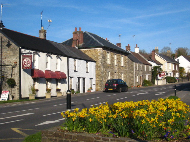
English: Fore Street Grampound, near to Grampound, Cornwall, Great Britain.
Grampound's linear layout is medieval, with long thin burgage plots extending away from the main street, Fore Street (A390). Most of the village core is a Conservation Area, and there are many listed buildings on Fore Street. Its name is from the Norman French grand (great) and pont (bridge) and it was an important crossing point on the River Fal. It was notorious as a rotten borough, returning two MPs to the House of Commons from the reign of Edward VI until it was disenfranchised in 1821, after a corruption scandal that led to the conviction and imprisonment of several people for bribery. |
| Tarih | |
| Kaynak | From geograph.org.uk; transferred by User:Skinsmoke using geograph_org2commons. |
| Yazar | Rod Allday |
| İzin (Bu dosyanın tekrar kullanımı) |
Creative Commons Attribution Share-alike license 2.0 |
| Atıf (required by the license) | Rod Allday / Fore Street Grampound / |
| Kamera pozisyonu | | Bu ve diğer görüntülerin konumlarını şurada belirle: OpenStreetMap |
|---|
| Nesne pozisyonu | | Bu ve diğer görüntülerin konumlarını şurada belirle: OpenStreetMap |
|---|
_region:GB-GBN_heading:90.00&language=tr)
Lisanslama

|
Bu Coğrafya projesinden alınmış olan bir görüntüdür. Coğrafi internet sitesinde bulunan bu fotoğraf sayfasından fotoğrafçıya ait iletişim bilgilerine ulaşabilirsiniz. Bu görüntünün telif hakkı sahibi Rod Allday olup, yeniden kullanılması amacıyla Creative Commons Attribution-ShareAlike 2.0 lisansı ile lisanslandırılmıştır.
|
Bu dosya, Creative Commons Atıf-Benzer Paylaşım 2.0 Genel lisansı ile lisanslanmıştır
Atıf: Rod Allday
- Şu seçeneklerde özgürsünüz:
- paylaşım – eser paylaşımı, dağıtımı ve iletimi
- içeriği değiştirip uyarlama – eser adaptasyonu
- Aşağıdaki koşullar geçerli olacaktır:
- atıf – Esere yazar veya lisans sahibi tarafından belirtilen (ancak sizi ya da eseri kullanımınızı desteklediklerini ileri sürmeyecek bir) şekilde atıfta bulunmalısınız.
- benzer paylaşım – Maddeyi yeniden karıştırır, dönüştürür veya inşa ederseniz, katkılarınızı orijinal olarak aynı veya uyumlu lisans altında dağıtmanız gerekir.
Dosya geçmişi
Dosyanın herhangi bir zamandaki hâli için ilgili tarih/saat kısmına tıklayın.
| Tarih/Saat | Küçük resim | Boyutlar | Kullanıcı | Yorum | |
|---|---|---|---|---|---|
| güncel | 04.00, 24 Eylül 2010 | | 640 × 480 (97 KB) | File Upload Bot (Magnus Manske) | == {{int:filedesc}} == {{Information |Description={{en|1=Fore Street Grampound, near to Grampound, Cornwall, Great Britain. Grampound's linear layout is medieval, with long thin burgage plots extending away from the main street, Fore Street (A390). M |
Dosya kullanımı
Bu görüntü dosyasına bağlantısı olan sayfalar:
Küresel dosya kullanımı
Aşağıdaki diğer vikiler bu dosyayı kullanır:
- en.wikipedia.org üzerinde kullanımı
- simple.wikipedia.org üzerinde kullanımı
- sv.wikipedia.org üzerinde kullanımı