
Dosya:Earthquake wave paths.png

Earthquake_wave_paths.png ((300 × 250 piksel, dosya boyutu: 13 KB, MIME tipi: image/png))
Bu dosya Wikimedia Commons'ta bulunmaktadır. Dosyanın açıklaması aşağıda gösterilmiştir. Commons, serbest/özgür telifli medya dosyalarının bulundurulduğu depodur. Siz de yardım edebilirsiniz. |

|
File:Earthquake wave paths.svg, bu dosyanın vektör versiyonudur. Aşağı olmadığında bu raster görüntünün yerine kullanılmalıdır.
File:Earthquake wave paths.png → File:Earthquake wave paths.svg
Daha fazla bilgi için Help:SVG/tr sayfasına bakın. |
 |
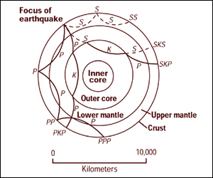
Cross section of the whole Earth, showing the complexity of paths of earthquake waves. The paths curve because the different rock types found at different depths change the speed at which the waves travel. Solid lines marked P are compressional waves; dashed lines marked S are shear waves. S waves do not travel through the core but may be converted to compressional waves (marked K) on entering the core (PKP, SKS). Waves may be reflected at the surface (PP, PPP, SS).
Seismographs detect the various types of waves. Analysis of such records reveals structures within the Earth.
Source: http://pubs.usgs.gov/gip/interior/fig2.gif ; original upload in english wikipedia, 15 April 2005 by SEWilco
Earthquake wave paths.png adlı görüntü kamu malıdır çünkü içeriği, ABD İç İşleri Bakanlığı (United States Department of Interior) bünyesindeki bir daire olan Birleşik Devletler Jeolojik Etüd (BDJE; United States Geological Survey, USGS) kökenli özgün malzeme ile ilgilidir.
Daha ayrıntılı bilgi için, bakın: BDJE'nin resmi telif hakkı uygulaması.
|
Orijinal yükleme günlüğü
| Tarih/Saat | Boyutlar | Kullanıcı | Yorum |
|---|---|---|---|
| 4 Eylül 2005, 12:53:16 | 300 × 250 (13208 bytes) | Saperaud (Tartışma · katkılar) | Cross section of the whole [[Earth]], showing the complexity of paths of [[earthquake]] waves. The paths curve because the different rock types found at different depths change the speed at which the waves travel. Solid lines marked P are compressional wa |
Dosya geçmişi
Dosyanın herhangi bir zamandaki hâli için ilgili tarih/saat kısmına tıklayın.
| Tarih/Saat | Küçük resim | Boyutlar | Kullanıcı | Yorum | |
|---|---|---|---|---|---|
| güncel | 16.54, 6 Ocak 2015 | | 300 × 250 (13 KB) | GifTagger | Bot: Converting file to superior PNG file. (Source: Earthquake_wave_paths.gif). This GIF was problematic due to non-greyscale color table. |
Dosya kullanımı
Bu görüntü dosyasına bağlantısı olan sayfalar:
Küresel dosya kullanımı
Aşağıdaki diğer vikiler bu dosyayı kullanır:
- ary.wikipedia.org üzerinde kullanımı
- cs.wikipedia.org üzerinde kullanımı
- de.wikipedia.org üzerinde kullanımı
- en.wikipedia.org üzerinde kullanımı
- es.wikipedia.org üzerinde kullanımı
- fi.wikipedia.org üzerinde kullanımı
- fr.wikipedia.org üzerinde kullanımı
- it.wikipedia.org üzerinde kullanımı
- nds.wikipedia.org üzerinde kullanımı
- sk.wikipedia.org üzerinde kullanımı
- Stavba Zeme
- Gutenbergova diskontinuita
- Portál:Vedy o Zemi
- Portál:Vedy o Zemi/Odporúčané články
- Portál:Vedy o Zemi/Odporúčaný článok/15 2007
- Portál:Vedy o Zemi/Odporúčaný článok/42 2007
- Portál:Vedy o Zemi/Odporúčané články/2007
- Portál:Vedy o Zemi/Odporúčaný článok/15
- Portál:Vedy o Zemi/Odporúčaný článok/53
- vi.wikipedia.org üzerinde kullanımı
- zh-yue.wikipedia.org üzerinde kullanımı
- zh.wikipedia.org üzerinde kullanımı