
Dosya:Crookston Commercial Historic District.jpg

Bu önizlemenin boyutu: 757 × 599 piksel. Diğer çözünürlükler: 303 × 240 piksel | 606 × 480 piksel | 956 × 757 piksel.
Tam çözünürlük ((956 × 757 piksel, dosya boyutu: 84 KB, MIME tipi: image/jpeg))
Bu dosya Wikimedia Commons'ta bulunmaktadır. Dosyanın açıklaması aşağıda gösterilmiştir. Commons, serbest/özgür telifli medya dosyalarının bulundurulduğu depodur. Siz de yardım edebilirsiniz. |
|
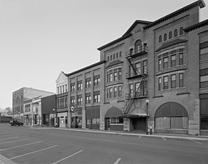
Bu Amerika Birleşik Devletleri'nde ABD Ulusal Tarihi Yapılar Listesinde listelenmiş olan bir yer veya bina görüntüsüdür. Referans numarası: 84002709.. |
| Açıklama |
English: Buildings in the Crookston Commercial Historic District in central Crookston, Polk County, Minnesota, United States. The district reflects the city's early period of growth, which was prompted by agriculture and the railroad industry. It remains a large, and mostly intact, concentration of late nineteenth- and early twentieth-century commercial structures and is listed on the National Register of Historic Places. |
|||||
| Tarih | Bilinmeyen tarih | |||||
| Kaynak | Library of Congress Prints and Photographs Division, Historic American Buildings Survey: MINN,60-CROK,1-6 | |||||
| Yazar | Anonim | |||||
| İzin (Bu dosyanın tekrar kullanımı) |
|

| Nesne pozisyonu | | Bu ve diğer görüntülerin konumlarını şurada belirle: OpenStreetMap |
|---|

|
Bu Görüntü, Amerika Birleşik Devletleri Kongre Kütüphanesi'nin dijital ID numarası hhh.mn0444 olan Baskılar ve Fotoğraflar Bölümü içerisinden ulaşılabilir.
Bu etiket, ekli çalışmanın telif hakkı durumunu göstermez. Normal bir telif hakkı etiketi hâlâ gereklidir. Commons:Lisanslama sayfasına bakın.
|
Dosya geçmişi
Dosyanın herhangi bir zamandaki hâli için ilgili tarih/saat kısmına tıklayın.
| Tarih/Saat | Küçük resim | Boyutlar | Kullanıcı | Yorum | |
|---|---|---|---|---|---|
| güncel | 14.07, 31 Ocak 2009 | | 956 × 757 (84 KB) | Cropbot | upload cropped version, operated by User:Finavon. Summary: border cropped |
| 14.35, 29 Ocak 2009 |  | 1.024 × 818 (96 KB) | Nyttend | {{Information |Description=Photograph from the {{w|Historic American Buildings Survey}} of buildings in the {{w|Crookston Commercial Historic District}}, an area listed on the {{w|National Register of Historic Places}}. The district is located in central |
Dosya kullanımı
Bu görüntü dosyasına bağlantısı olan sayfalar:
Küresel dosya kullanımı
Aşağıdaki diğer vikiler bu dosyayı kullanır:
- ar.wikipedia.org üzerinde kullanımı
- arz.wikipedia.org üzerinde kullanımı
- azb.wikipedia.org üzerinde kullanımı
- be.wikipedia.org üzerinde kullanımı
- ca.wikipedia.org üzerinde kullanımı
- ceb.wikipedia.org üzerinde kullanımı
- ce.wikipedia.org üzerinde kullanımı
- dag.wikipedia.org üzerinde kullanımı
- de.wikipedia.org üzerinde kullanımı
- en.wikipedia.org üzerinde kullanımı
- en.wikivoyage.org üzerinde kullanımı
- es.wikipedia.org üzerinde kullanımı
- eu.wikipedia.org üzerinde kullanımı
- fa.wikipedia.org üzerinde kullanımı
- fr.wikipedia.org üzerinde kullanımı
- ht.wikipedia.org üzerinde kullanımı
- hu.wikipedia.org üzerinde kullanımı
- ia.wikipedia.org üzerinde kullanımı
- ko.wikipedia.org üzerinde kullanımı
- ky.wikipedia.org üzerinde kullanımı
- lld.wikipedia.org üzerinde kullanımı
- pt.wikipedia.org üzerinde kullanımı
- ru.wikipedia.org üzerinde kullanımı
- sh.wikipedia.org üzerinde kullanımı
- sr.wikipedia.org üzerinde kullanımı
- tt.wikipedia.org üzerinde kullanımı
- uk.wikipedia.org üzerinde kullanımı
- ur.wikipedia.org üzerinde kullanımı
- uz.wikipedia.org üzerinde kullanımı
- vi.wikipedia.org üzerinde kullanımı
- www.wikidata.org üzerinde kullanımı
- zh-min-nan.wikipedia.org üzerinde kullanımı