
Dosya:Capecod oli 2020055.jpeg
Bu önizlemenin boyutu: 600 × 600 piksel. Diğer çözünürlükler: 240 × 240 piksel | 480 × 480 piksel | 720 × 720 piksel.
Tam çözünürlük ((720 × 720 piksel, dosya boyutu: 145 KB, MIME tipi: image/jpeg))
Bu dosya Wikimedia Commons'ta bulunmaktadır. Dosyanın açıklaması aşağıda gösterilmiştir. Commons, serbest/özgür telifli medya dosyalarının bulundurulduğu depodur. Siz de yardım edebilirsiniz. |
Özet
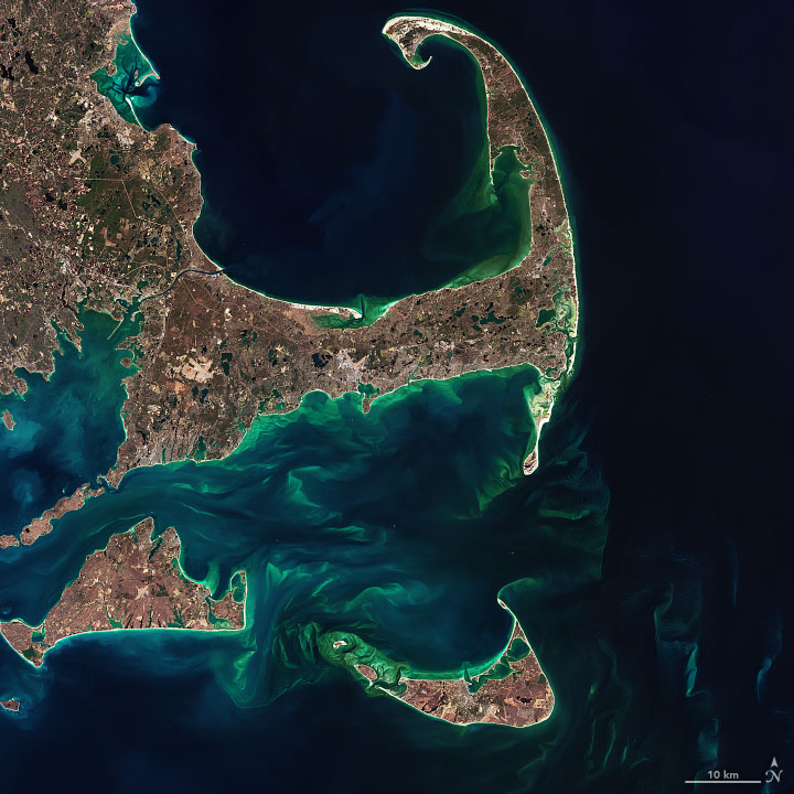
| Açıklama | The image below—a closeup of Cape Cod, Martha’s Vineyard, Nantucket, and the shoals between them—was acquired by the Operational Land Imager (OLI) on the Landsat 8 satellite on February 24, 2020. |
| Tarih | |
| Kaynak | https://earthobservatory.nasa.gov/images/146412/hints-of-spring-in-the-atlantic |
| Yazar | NASA Earth Observatory images by Joshua Stevens and Norman Kuring, using Landsat data from the U.S. Geological Survey |
Lisanslama
| Bu dosya NASA tarafından üretildiği için kamu malıdır. Aksi belirtilmediği sürece "NASA tarafından üretilen malzemenin telif hakkı olmadığı" NASA telif politikasında belirtilmiştir. (Bkz. Template:PD-USGov, NASA copyright policy page veya JPL Image Use Policy.) | ||
 |
Uyarılar:
|
Dosya geçmişi
Dosyanın herhangi bir zamandaki hâli için ilgili tarih/saat kısmına tıklayın.
| Tarih/Saat | Küçük resim | Boyutlar | Kullanıcı | Yorum | |
|---|---|---|---|---|---|
| güncel | 03.06, 26 Mayıs 2021 | | 720 × 720 (145 KB) | StellarHalo | {{Information |Description=The image below—a closeup of Cape Cod, Martha’s Vineyard, Nantucket, and the shoals between them—was acquired by the Operational Land Imager (OLI) on the Landsat 8 satellite on February 24, 2020. |Source=https://earthobservatory.nasa.gov/images/146412/hints-of-spring-in-the-atlantic |Date=24 February 2020 |Author=NASA Earth Observatory images by Joshua Stevens and Norman Kuring, using Landsat data from the U.S. Geological Survey |Permission= |other_versions= }} [[Ca... |
Dosya kullanımı
Bu görüntü dosyasına bağlanan sayfa yok.
Küresel dosya kullanımı
Aşağıdaki diğer vikiler bu dosyayı kullanır:
- af.wikipedia.org üzerinde kullanımı