
Dosya:Autonome Region Kurdistan (Karte).png

Bu önizlemenin boyutu: 581 × 599 piksel. Diğer çözünürlükler: 233 × 240 piksel | 465 × 480 piksel | 1.012 × 1.044 piksel.
Tam çözünürlük ((1.012 × 1.044 piksel, dosya boyutu: 278 KB, MIME tipi: image/png))
Bu dosya Wikimedia Commons'ta bulunmaktadır. Dosyanın açıklaması aşağıda gösterilmiştir. Commons, serbest/özgür telifli medya dosyalarının bulundurulduğu depodur. Siz de yardım edebilirsiniz. |
| Açıklama |
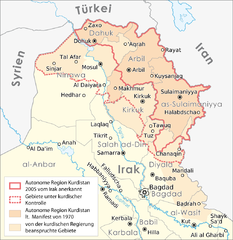
Deutsch: Karte: Autonome Region Kurdistan |
||
| Tarih | |||
| Kaynak |
Self made, using |
||
| Yazar |
Maximilian Dörrbecker (Chumwa)
|
||
| İzin (Bu dosyanın tekrar kullanımı) |
Ben, bu işin telif sahibi, burada işi aşağıdaki lisans altında yayımlıyorum: Bu dosya, Creative Commons Atıf-Benzer Paylaşım 2.5 Genel lisansı ile lisanslanmıştır
Sie dürfen das Bild zu den folgenden Bedingungen nutzen:
|
||
| Diğer sürümler |
|


.png)
| Annotations | This image is annotated: View the annotations at Commons |
Dosya geçmişi
Dosyanın herhangi bir zamandaki hâli için ilgili tarih/saat kısmına tıklayın.
| Tarih/Saat | Küçük resim | Boyutlar | Kullanıcı | Yorum | |
|---|---|---|---|---|---|
| güncel | 13.26, 15 Ağustos 2016 | | 1.012 × 1.044 (278 KB) | Denniss | Reverted to version as of 17:02, 22 September 2008 (UTC) |
| 19.32, 5 Ağustos 2016 |  | 1.012 × 1.044 (227 KB) | Beshogur | Reverted to version as of 06:40, 21 June 2008 (UTC) Mosul, Tal Afar is not under KRG controll. | |
| 18.55, 16 Eylül 2011 |  | 1.012 × 1.044 (278 KB) | Kathovo | Reverted to version as of 21:38, 14 August 2010 | |
| 20.51, 19 Ağustos 2010 |  | 1.012 × 1.044 (202 KB) | Saadwand | Reverted to version as of 11:32, 14 August 2010 | |
| 21.38, 14 Ağustos 2010 |  | 1.012 × 1.044 (278 KB) | 84user | Reverted to version as of 17:02, 22 September 2008 reverting apparenty erroneous colour change | |
| 11.32, 14 Ağustos 2010 |  | 1.012 × 1.044 (202 KB) | Abuadab | minore colour change. | |
| 17.02, 22 Eylül 2008 |  | 1.012 × 1.044 (278 KB) | Chumwa | Informationen aus [http://www.washingtonpost.com/wp-dyn/content/graphic/2008/09/13/GR2008091300327.html dieser Karte] integriert. | |
| 06.40, 21 Haziran 2008 |  | 1.012 × 1.044 (227 KB) | Chumwa | diverse Anmerkungen eingearbeitet | |
| 05.00, 20 Haziran 2008 |  | 1.012 × 1.044 (284 KB) | Chumwa | Komplett neuer Aufbau der Karte | |
| 17.24, 16 Haziran 2008 |  | 831 × 784 (37 KB) | Chumwa | {{Information |Description= {{ de }} Karte: Autonome Region Kurdistan |Source=Self made, using * base map #1 * base map #2 |Date=June 2008 |Author=[[:de:User:Chumwa|Maximil |
Dosya kullanımı
Bu görüntü dosyasına bağlantısı olan sayfalar:
Küresel dosya kullanımı
Aşağıdaki diğer vikiler bu dosyayı kullanır:
- de.wikipedia.org üzerinde kullanımı
- ku.wikipedia.org üzerinde kullanımı
.png)