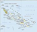
Dosya:Political map of the Solomon Islands archipelago in 1989.jpg

Bu önizlemenin boyutu: 690 × 600 piksel. Diğer çözünürlükler: 276 × 240 piksel | 552 × 480 piksel | 748 × 650 piksel.
Tam çözünürlük ((748 × 650 piksel, dosya boyutu: 72 KB, MIME tipi: image/jpeg))
Dosya geçmişi
Dosyanın herhangi bir zamandaki hâli için ilgili tarih/saat kısmına tıklayın.
| Tarih/Saat | Küçük resim | Boyutlar | Kullanıcı | Yorum | |
|---|---|---|---|---|---|
| güncel | 02.06, 12 Nisan 2016 |  | 748 × 650 (72 KB) | Nimbosa | Reverted to version as of 02:02, 12 April 2016 (UTC) |
| 02.05, 12 Nisan 2016 |  | 748 × 650 (72 KB) | Nimbosa | restored to original color as on print, corrected color map | |
| 02.02, 12 Nisan 2016 |  | 748 × 650 (72 KB) | Nimbosa | restored to original color as on print, corrected color map | |
| 21.09, 1 Mart 2007 |  | 748 × 650 (72 KB) | Pibwl |
Dosya kullanımı
Bu görüntü dosyasına bağlantısı olan sayfalar:
Küresel dosya kullanımı
Aşağıdaki diğer vikiler bu dosyayı kullanır:
- als.wikipedia.org üzerinde kullanımı
- ami.wikipedia.org üzerinde kullanımı
- ast.wikipedia.org üzerinde kullanımı
- bg.wikipedia.org üzerinde kullanımı
- bn.wikipedia.org üzerinde kullanımı
- ca.wikipedia.org üzerinde kullanımı
- ceb.wikipedia.org üzerinde kullanımı
- cs.wikipedia.org üzerinde kullanımı
- da.wikipedia.org üzerinde kullanımı
- el.wikipedia.org üzerinde kullanımı
- en.wikipedia.org üzerinde kullanımı
- en.wiktionary.org üzerinde kullanımı
- es.wikipedia.org üzerinde kullanımı
- fa.wikipedia.org üzerinde kullanımı
- fi.wikipedia.org üzerinde kullanımı
- fr.wikipedia.org üzerinde kullanımı
- gl.wikipedia.org üzerinde kullanımı
- hu.wikipedia.org üzerinde kullanımı
- hy.wikipedia.org üzerinde kullanımı
- hyw.wikipedia.org üzerinde kullanımı
- id.wikipedia.org üzerinde kullanımı
- it.wikipedia.org üzerinde kullanımı
- ja.wikipedia.org üzerinde kullanımı
- ka.wikipedia.org üzerinde kullanımı
- kk.wikipedia.org üzerinde kullanımı
Bu dosyanın daha fazla küresel kullanımını görüntüle.


