
Dosya:Xinjiang Internment Map, US-Aus Gov Assessment.jpg
Bu önizlemenin boyutu: 800 × 495 piksel. Diğer çözünürlükler: 320 × 198 piksel | 640 × 396 piksel | 1.024 × 634 piksel | 1.280 × 792 piksel | 2.048 × 1.267 piksel.
Tam çözünürlük ((2.048 × 1.267 piksel, dosya boyutu: 150 KB, MIME tipi: image/jpeg))
Bu dosya Wikimedia Commons'ta bulunmaktadır. Dosyanın açıklaması aşağıda gösterilmiştir. Commons, serbest/özgür telifli medya dosyalarının bulundurulduğu depodur. Siz de yardım edebilirsiniz. |
Özet
| Açıklama |
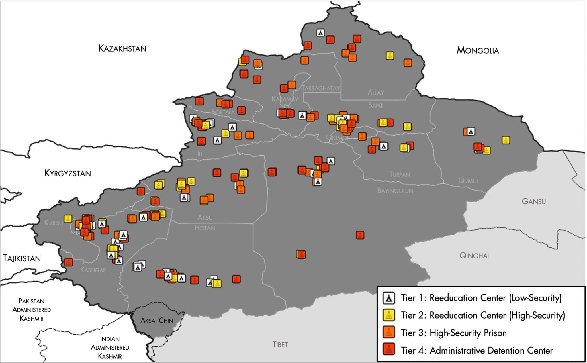
English: Map of the Xinjiang Internment Camps created by the RAND Corporation based on data collected by the US National Geospatial Intelligence Agency and the Australian Strategic Policy Institute. Open source here. |
||||||||
| Tarih | |||||||||
| Kaynak | https://www.tearline.mil/public_page/xinjiang-nighttime-1/ | ||||||||
| Yazar | National Geospatial Intelligence Agency, using data from the Australian Strategic Policy Institute, and administrative boundaries from GADM. | ||||||||
| İzin (Bu dosyanın tekrar kullanımı) |
|


Dosya geçmişi
Dosyanın herhangi bir zamandaki hâli için ilgili tarih/saat kısmına tıklayın.
| Tarih/Saat | Küçük resim | Boyutlar | Kullanıcı | Yorum | |
|---|---|---|---|---|---|
| güncel | 05.05, 2 Mayıs 2021 | | 2.048 × 1.267 (150 KB) | Abovfold | Uploaded a work by {{w|National Geospatial Intelligence Agency}}, using data from the {{w|Australian Strategic Policy Institute}}, and administrative boundaries from {{w|GADM}}. from https://www.tearline.mil/public_page/xinjiang-nighttime-1/ with UploadWizard |
Dosya kullanımı
Bu görüntü dosyasına bağlantısı olan sayfalar:
Küresel dosya kullanımı
Aşağıdaki diğer vikiler bu dosyayı kullanır:
- ba.wikipedia.org üzerinde kullanımı
- br.wikipedia.org üzerinde kullanımı
- cs.wikipedia.org üzerinde kullanımı
- de.wikipedia.org üzerinde kullanımı
- el.wikipedia.org üzerinde kullanımı
- en.wikipedia.org üzerinde kullanımı
- es.wikipedia.org üzerinde kullanımı
- fi.wikipedia.org üzerinde kullanımı
- fr.wikipedia.org üzerinde kullanımı
- ga.wikipedia.org üzerinde kullanımı
- he.wikipedia.org üzerinde kullanımı
- km.wikipedia.org üzerinde kullanımı
- nl.wikipedia.org üzerinde kullanımı
- or.wikipedia.org üzerinde kullanımı
- pl.wikipedia.org üzerinde kullanımı
- pt.wikipedia.org üzerinde kullanımı
- ru.wikinews.org üzerinde kullanımı
- sv.wikipedia.org üzerinde kullanımı
- szl.wikipedia.org üzerinde kullanımı
- www.wikidata.org üzerinde kullanımı