
Dosya:Waterpocket Fold - Looking south from the Strike Valley Overlook.jpg
Daha yüksek çözünürlüğe sahip sürüm bulunmamaktadır.
Waterpocket_Fold_-_Looking_south_from_the_Strike_Valley_Overlook.jpg ((800 × 600 piksel, dosya boyutu: 592 KB, MIME tipi: image/jpeg))
Bu dosya Wikimedia Commons'ta bulunmaktadır. Dosyanın açıklaması aşağıda gösterilmiştir. Commons, serbest/özgür telifli medya dosyalarının bulundurulduğu depodur. Siz de yardım edebilirsiniz. |
| Açıklama |
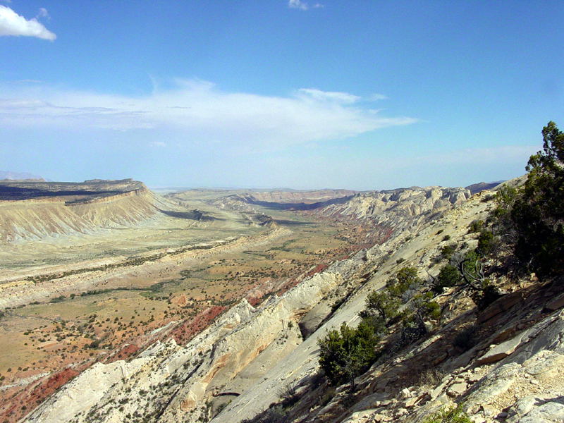
English: Perhaps the most amazing view in the region is this scene looking south from the Strike Valley Overlook along a great, warping arc in the greater Waterpocket Fold. The scene encompasses about a 2 kilometer thick section of sedimentary rocks and landscape features representing more than 200 million years of earth surface processes and conditions. The oldest sedimentary rocks on the right (the Navajo Sandstone) represents a great blanket of desert dunes that extended across the region at the close of Triassic time. Morrison Formation in the center represents the changes in Jurassic time when the great dune fields gave way to coastal floodplains, swamps, and shallow inland seas. The Mancos Shale represents the formation of a great inland Western Interior Seaway that lasted in the region through almost all of Cretaceous time. Finally this seaway withdrew at the close of Cretaceous time, the land rose, and volcanoes of the Henry Mountains formed in early Tertiary time (probably during the Oligocene Epoch between 37 and 24 million years ago). Since middle Tertiary time, the land has been steadily rising and eroding, perhaps at an increasing rate with the development of the modern Colorado River system across the region. |
|||
| Tarih | 8 Ağustos 2003 (according to Exif data) | |||
| Kaynak | USGS – 3dparks.wr.usgs.gov | |||
| Yazar | Bilinmiyor | |||
| İzin (Bu dosyanın tekrar kullanımı) |
|
Dosya geçmişi
Dosyanın herhangi bir zamandaki hâli için ilgili tarih/saat kısmına tıklayın.
| Tarih/Saat | Küçük resim | Boyutlar | Kullanıcı | Yorum | |
|---|---|---|---|---|---|
| güncel | 03.05, 16 Mart 2006 | | 800 × 600 (592 KB) | Mav | USGS image from [http://3dparks.wr.usgs.gov/capitol2/html/3d4665.html] Perhaps the most amazing view in the region is this scene looking south from the Strike Valley Overlook along a great, warping arc in the greater Waterpocket Fold. The scene encompass |
Dosya kullanımı
Bu görüntü dosyasına bağlantısı olan sayfalar:
Küresel dosya kullanımı
Aşağıdaki diğer vikiler bu dosyayı kullanır:
- ar.wikipedia.org üzerinde kullanımı
- bg.wikipedia.org üzerinde kullanımı
- en.wikipedia.org üzerinde kullanımı
- es.wikipedia.org üzerinde kullanımı
- fr.wikipedia.org üzerinde kullanımı
- gl.wikipedia.org üzerinde kullanımı
- ja.wikipedia.org üzerinde kullanımı
- lt.wikipedia.org üzerinde kullanımı