
Dosya:Roman Africa.JPG
Tam çözünürlük ((3.057 × 2.439 piksel, dosya boyutu: 1,95 MB, MIME tipi: image/jpeg))
Bu dosya Wikimedia Commons'ta bulunmaktadır. Dosyanın açıklaması aşağıda gösterilmiştir. Commons, serbest/özgür telifli medya dosyalarının bulundurulduğu depodur. Siz de yardım edebilirsiniz. |
Özet
| Açıklama |
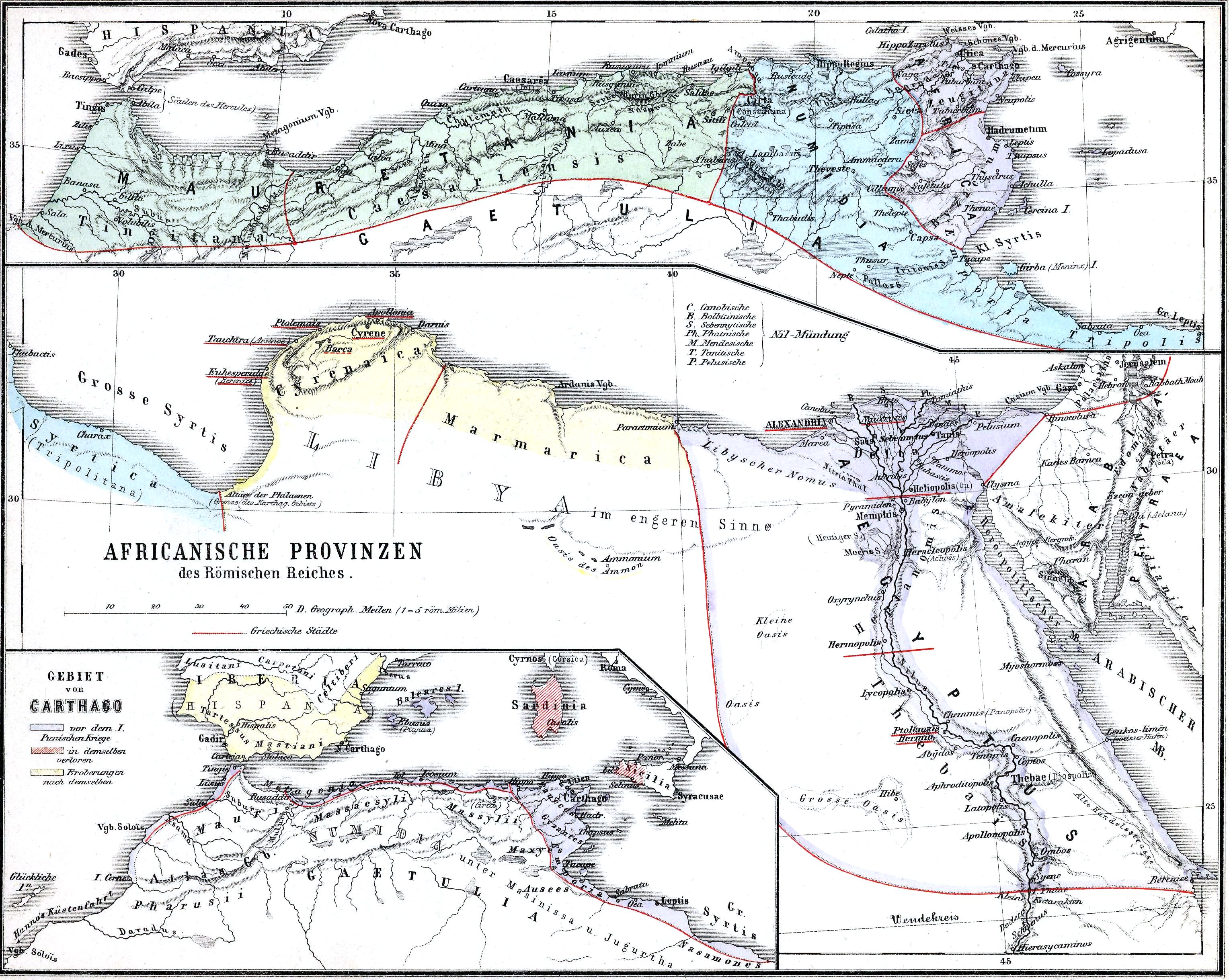
English: The African provinces of the Roman Empire. The smaller map in the lower left shows the territory of the pre-Roman state of Carthage (blue), with yellow showing conquests and hashed red indicating territory lost to Rome in the First Punic War. |
| Tarih | |
| Kaynak | Historischer Schulatlas. |
| Yazar | H. Kiepert |
Lisanslama
|
Bu çalışma ABD'de veya yazarın yaşamının sona ermiş olmasından 70 veya daha fazla süre geçtiğinde bu duruma uygun telif yasaları olan tüm ülkelerde kamu malıdır.
| |
| Bu dosyanın, tüm ilgili ve komşu haklar da dâhil olmak üzere, telif hakkı yasası kapsamında bilinen kısıtlamalardan arınmış olduğu belirlendi. | |
Dosya geçmişi
Dosyanın herhangi bir zamandaki hâli için ilgili tarih/saat kısmına tıklayın.
| Tarih/Saat | Küçük resim | Boyutlar | Kullanıcı | Yorum | |
|---|---|---|---|---|---|
| güncel | 15.37, 15 Kasım 2009 | | 3.057 × 2.439 (1,95 MB) | Alex:D | whitened |
| 22.37, 14 Şubat 2009 |  | 3.057 × 2.439 (1,55 MB) | Olahus | {{Information |Description=Nothern Africa under Roman rule. |Source=Historischer Schulatlas. |Date=1879 |Author=H.Kiepert |Permission= |other_versions= }} {{PD-old}} Category:Old maps of Africa Category:Old maps of the Roman Empire [[Category:Maps |
Dosya kullanımı
Bu görüntü dosyasına bağlantısı olan sayfalar:
Küresel dosya kullanımı
Aşağıdaki diğer vikiler bu dosyayı kullanır:
- ar.wikipedia.org üzerinde kullanımı
- arz.wikipedia.org üzerinde kullanımı
- bg.wikipedia.org üzerinde kullanımı
- ca.wikipedia.org üzerinde kullanımı
- cs.wikipedia.org üzerinde kullanımı
- de.wikipedia.org üzerinde kullanımı
- de.wikivoyage.org üzerinde kullanımı
- de.wiktionary.org üzerinde kullanımı
- el.wikipedia.org üzerinde kullanımı
- en.wikipedia.org üzerinde kullanımı
- Numidia
- North Africa during classical antiquity
- Roman Egypt
- Byzacena
- Myos Hormos
- Tacfarinas
- List of revolutions and rebellions
- Aquae Regiae
- User:Olahus
- Uzita (Tunisia)
- El Milia
- Aggersel
- Quiza Xenitana
- Berber kings of Roman-era Tunisia
- Diocese of Maxita
- Aquae Albae in Byzacena
- Decoriana
- Simminensis (diocese)
- Zerta
- Titular Bishopric of Vita
- Elephantaria in Mauretania
- Tubia in Mauretania
- Tabuda
- Lari Castellum
- User:Ryanmhorne/pleiades List
- Ancient Africa
- eo.wikipedia.org üzerinde kullanımı
- es.wikipedia.org üzerinde kullanımı
- et.wikipedia.org üzerinde kullanımı
- eu.wikipedia.org üzerinde kullanımı
- fa.wikipedia.org üzerinde kullanımı
- fr.wikipedia.org üzerinde kullanımı
Bu dosyanın daha fazla küresel kullanımını görüntüle.