
Dosya:Rear map.jpg

Tam çözünürlük ((2.201 × 1.617 piksel, dosya boyutu: 1,61 MB, MIME tipi: image/jpeg))
Bu dosya Wikimedia Commons'ta bulunmaktadır. Dosyanın açıklaması aşağıda gösterilmiştir. Commons, serbest/özgür telifli medya dosyalarının bulundurulduğu depodur. Siz de yardım edebilirsiniz. |
Özet
| Açıklama |
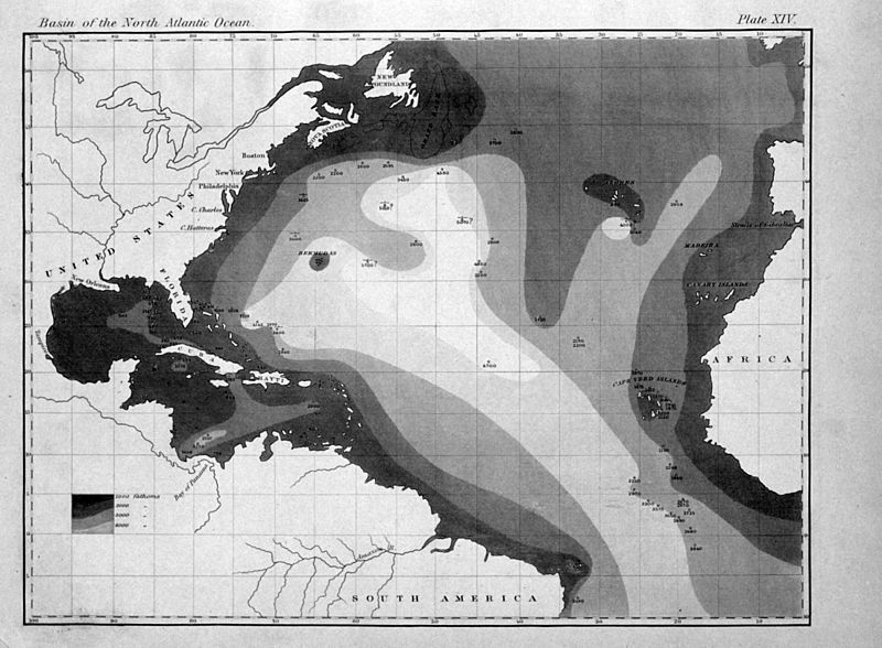
English: "The very earliest rendition of a bathymetric map of an oceanic basin. Matthew Fontaine Maury published this map in 1853 in Explanations and Sailing Directions to Accompany the Wind and Current Charts." |
| Tarih | |
| Kaynak |
http://oceanexplorer.noaa.gov/history/readings/vicissitudes/media/gulf.html |
| Yazar | Matthew Fontaine Maury |
Lisanslama
Rear map.jpg adlı görüntü kamu malıdır çünkü içeriği, ABD Ulusal Okyanus ve Atmosfer Dairesi (National Oceanic and Atmospheric Administration, NOAA) kökenli özgün malzeme ile ilgilidir.
|
|
Bu çalışma ABD'de veya yazarın yaşamının sona ermiş olmasından 70 veya daha fazla süre geçtiğinde bu duruma uygun telif yasaları olan tüm ülkelerde kamu malıdır.
| |
| Bu dosyanın, tüm ilgili ve komşu haklar da dâhil olmak üzere, telif hakkı yasası kapsamında bilinen kısıtlamalardan arınmış olduğu belirlendi. | |
Dosya geçmişi
Dosyanın herhangi bir zamandaki hâli için ilgili tarih/saat kısmına tıklayın.
| Tarih/Saat | Küçük resim | Boyutlar | Kullanıcı | Yorum | |
|---|---|---|---|---|---|
| güncel | 16.31, 6 Ağustos 2011 | | 2.201 × 1.617 (1,61 MB) | Belg4mit | {{Information |Description ={{en|1="The very earliest rendition of a bathymetric map of an oceanic basin. Matthew Fontaine Maury published this map in 1853 in ''Explanations and Sailing Directions to Accompany the Wind and Current Charts''."}} |Sou |
Dosya kullanımı
Bu görüntü dosyasına bağlantısı olan sayfalar:
Küresel dosya kullanımı
Aşağıdaki diğer vikiler bu dosyayı kullanır:
- bg.wikipedia.org üzerinde kullanımı
- en.wikipedia.org üzerinde kullanımı
- eo.wikipedia.org üzerinde kullanımı
- fa.wikipedia.org üzerinde kullanımı
- fr.wikipedia.org üzerinde kullanımı
- mk.wikipedia.org üzerinde kullanımı
- pt.wikipedia.org üzerinde kullanımı
- zh.wikipedia.org üzerinde kullanımı