
Dosya:NEAT GBT engl.png

Bu önizlemenin boyutu: 539 × 600 piksel. Diğer çözünürlükler: 216 × 240 piksel | 431 × 480 piksel | 852 × 948 piksel.
Tam çözünürlük ((852 × 948 piksel, dosya boyutu: 1,91 MB, MIME tipi: image/png))
Bu dosya Wikimedia Commons'ta bulunmaktadır. Dosyanın açıklaması aşağıda gösterilmiştir. Commons, serbest/özgür telifli medya dosyalarının bulundurulduğu depodur. Siz de yardım edebilirsiniz. |
Özet
| Açıklama |
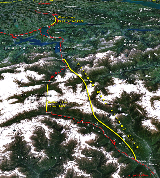
Situation of the northern part of the Gotthard axis as part of the New Railway Link through the Alps NRLA / Alptransit project in Switzerland with Gotthard and Zimmerberg base tunnels |
| Tarih | |
| Kaynak | topomap: produced with NASA WorldWind 1.3 / overlay drawing by: Cooper.ch |
| Yazar | --Cooper.ch 19:30, 12 August 2006 (UTC) |
| İzin (Bu dosyanın tekrar kullanımı) |
NASA satellite imagery is in public domain, and so is my overlay drawing |
| Diğer sürümler | Original german version on de.wikipedia.org, named Bild:NEAT_Gotthardachse.png |
Lisanslama
| Bu dosya NASA tarafından üretildiği için kamu malıdır. Aksi belirtilmediği sürece "NASA tarafından üretilen malzemenin telif hakkı olmadığı" NASA telif politikasında belirtilmiştir. (Bkz. Template:PD-USGov, NASA copyright policy page veya JPL Image Use Policy.) | ||
 |
Uyarılar:
|
| Annotations | This image is annotated: View the annotations at Commons |


Dosya geçmişi
Dosyanın herhangi bir zamandaki hâli için ilgili tarih/saat kısmına tıklayın.
| Tarih/Saat | Küçük resim | Boyutlar | Kullanıcı | Yorum | |
|---|---|---|---|---|---|
| güncel | 19.30, 12 Ağustos 2006 | | 852 × 948 (1,91 MB) | Cooper.ch | {{Information |Description=Situation of the northern axis of the New Railway Link through the Alps NRLA in Switzerland with Gotthard and Zimmerberg base tunnels |Source=topomap: produced with NASA WorldWind 1.3 / drawing overlay by: [[User:Cooper.ch|Coope |
Dosya kullanımı
Bu görüntü dosyasına bağlantısı olan sayfalar:
Küresel dosya kullanımı
Aşağıdaki diğer vikiler bu dosyayı kullanır:
- ast.wikipedia.org üzerinde kullanımı
- bh.wikipedia.org üzerinde kullanımı
- da.wikipedia.org üzerinde kullanımı
- en.wikipedia.org üzerinde kullanımı
- es.wikipedia.org üzerinde kullanımı
- fa.wikipedia.org üzerinde kullanımı
- fi.wikipedia.org üzerinde kullanımı
- fr.wikipedia.org üzerinde kullanımı
- he.wikipedia.org üzerinde kullanımı
- hr.wikipedia.org üzerinde kullanımı
- ja.wikipedia.org üzerinde kullanımı
- jv.wikipedia.org üzerinde kullanımı
- ml.wikipedia.org üzerinde kullanımı
- my.wikipedia.org üzerinde kullanımı
- nl.wikipedia.org üzerinde kullanımı
- no.wikipedia.org üzerinde kullanımı
- pt.wikipedia.org üzerinde kullanımı
- rm.wikipedia.org üzerinde kullanımı
- ro.wikipedia.org üzerinde kullanımı
- sh.wikipedia.org üzerinde kullanımı
- sl.wikipedia.org üzerinde kullanımı
- sv.wikipedia.org üzerinde kullanımı
- ta.wikinews.org üzerinde kullanımı
- zh.wikipedia.org üzerinde kullanımı