
Dosya:Map of the route of Edward III's chevauchée of 1346.svg

Bu SVG dosyasının PNG önizlemesinin boyutu: 643 × 600 piksel. Diğer çözünürlükler: 257 × 240 piksel | 515 × 480 piksel | 823 × 768 piksel | 1.098 × 1.024 piksel | 2.195 × 2.048 piksel | 1.059 × 988 piksel.
Tam çözünürlük (SVG dosyası, sözde 1.059 × 988 piksel, dosya boyutu: 450 KB)
Bu dosya Wikimedia Commons'ta bulunmaktadır. Dosyanın açıklaması aşağıda gösterilmiştir. Commons, serbest/özgür telifli medya dosyalarının bulundurulduğu depodur. Siz de yardım edebilirsiniz. |
Özet
| Açıklama |
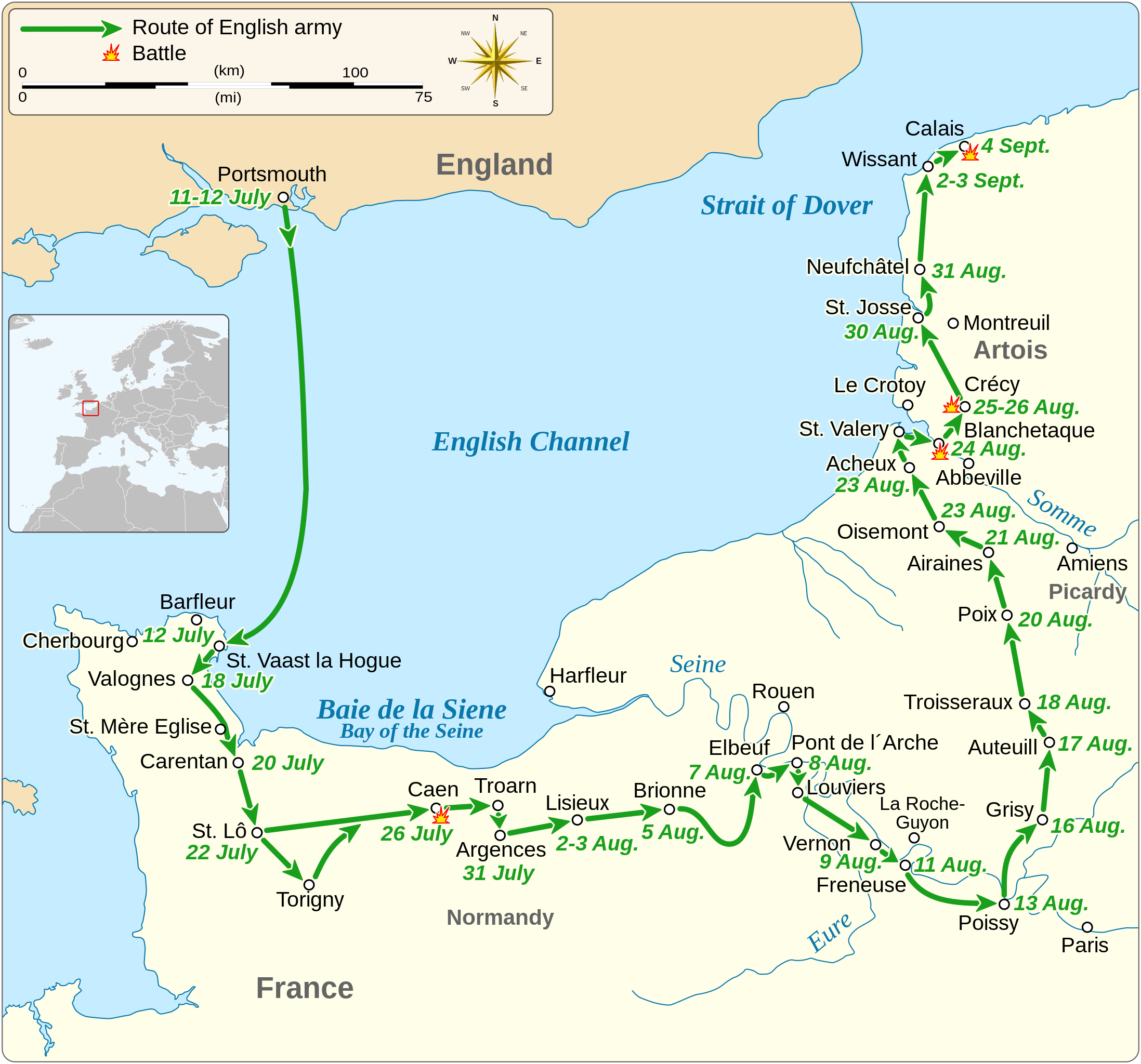
English: Map of the route of Edward III's chevauchée of 1346, part of the Hundred Years' War. This map shows the English army movements during the campaign and the most important battles.
|
||||||||||||||||||||||||||||||||||||||||||||||||
| Tarih | |||||||||||||||||||||||||||||||||||||||||||||||||
| Kaynak |
Yükleyenin kendi çalışması Derived from; Information from:
|
||||||||||||||||||||||||||||||||||||||||||||||||
| Yazar | Goran tek-en | ||||||||||||||||||||||||||||||||||||||||||||||||
| İzin (Bu dosyanın tekrar kullanımı) |
Bu dosya, Creative Commons Atıf-Benzer Paylaşım 4.0 Uluslararası lisansı ile lisanslanmıştır. Atıf: Goran tek-en
|
||||||||||||||||||||||||||||||||||||||||||||||||
| SVG gelişimi | Bu SVG kaynak kodu geçerlidir. Bu vektörel grafik Inkscape ile oluşturuldu. |
||||||||||||||||||||||||||||||||||||||||||||||||


| Nesne pozisyonu | | Bu ve diğer görüntülerin konumlarını şurada belirle: OpenStreetMap |
|---|


Dosya geçmişi
Dosyanın herhangi bir zamandaki hâli için ilgili tarih/saat kısmına tıklayın.
| Tarih/Saat | Küçük resim | Boyutlar | Kullanıcı | Yorum | |
|---|---|---|---|---|---|
| güncel | 00.14, 3 Şubat 2022 | | 1.059 × 988 (450 KB) | Iso10970 | Reverted to version as of 13:17, 9 November 2021 (UTC) |
| 00.13, 3 Şubat 2022 |  | 1.059 × 988 (614 KB) | Iso10970 | File uploaded using svgtranslate tool (https://svgtranslate.toolforge.org/). Added translation for ja. | |
| 13.17, 9 Kasım 2021 |  | 1.059 × 988 (450 KB) | Goran tek-en | Changed view box, font size, added location map | |
| 13.06, 14 Nisan 2019 |  | 1.059 × 988 (191 KB) | Goran tek-en | Spelling | |
| 17.53, 10 Mart 2019 |  | 1.059 × 988 (115 KB) | JoKalliauer | phab:T36947 bad character aligment on same sizes | |
| 14.08, 6 Mart 2019 |  | 1.059 × 988 (191 KB) | Goran tek-en | {{Information |description ={{en|1=Map of the route of Edward III's chevauchée of 1346, part of the Hundred Years' War. This map shows the English army movements during the campaign and the most important battles.}} |date =20190306 |source ={{Own}}<br> Derived from; * [https://www.openstreetmap.org/#map=8/49.919/1.371 OSM] Information from: * [https://www.themaparchive.com/the-crecy-campaign-12-july-to-4-september-1346.html themaparchive.com] * {{U|Newm30}} |author... |
Dosya kullanımı
Bu görüntü dosyasına bağlantısı olan sayfalar:
Küresel dosya kullanımı
Aşağıdaki diğer vikiler bu dosyayı kullanır:
- cs.wikipedia.org üzerinde kullanımı
- en.wikipedia.org üzerinde kullanımı
- es.wikipedia.org üzerinde kullanımı
- fi.wikipedia.org üzerinde kullanımı
- fr.wikipedia.org üzerinde kullanımı
- hu.wikipedia.org üzerinde kullanımı
- ja.wikipedia.org üzerinde kullanımı
- nl.wikipedia.org üzerinde kullanımı
- pt.wikipedia.org üzerinde kullanımı
- ru.wikipedia.org üzerinde kullanımı
- sh.wikipedia.org üzerinde kullanımı
- zh.wikipedia.org üzerinde kullanımı