
Dosya:Map of Glacier National Park.PNG

Bu önizlemenin boyutu: 527 × 600 piksel. Diğer çözünürlükler: 211 × 240 piksel | 422 × 480 piksel | 675 × 768 piksel | 900 × 1.024 piksel | 1.657 × 1.885 piksel.
Tam çözünürlük ((1.657 × 1.885 piksel, dosya boyutu: 2,44 MB, MIME tipi: image/png))
Bu dosya Wikimedia Commons'ta bulunmaktadır. Dosyanın açıklaması aşağıda gösterilmiştir. Commons, serbest/özgür telifli medya dosyalarının bulundurulduğu depodur. Siz de yardım edebilirsiniz. |
Özet
| Açıklama |
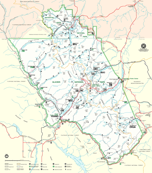
English: Map of Glacier National Park, Montana, USA and Waterton Lakes National Park, Alberta, Canada |
| Kaynak | http://www.nps.gov/glac/images/bigmap.gif |
| Yazar | US-NPS |
Lisanslama
| This image or media file contains material based on a work of a National Park Service employee, created as part of that person's official duties. As a work of the U.S. federal government, such work is in the public domain in the United States. See the NPS website and NPS copyright policy for more information. |
Dosya geçmişi
Dosyanın herhangi bir zamandaki hâli için ilgili tarih/saat kısmına tıklayın.
| Tarih/Saat | Küçük resim | Boyutlar | Kullanıcı | Yorum | |
|---|---|---|---|---|---|
| güncel | 11.01, 13 Mayıs 2006 | | 1.657 × 1.885 (2,44 MB) | MONGO | {{Information| |Description=Map of Glacier National Park |Source=http://www.nps.gov/glac/images/bigmap.gif |Date= |Author= |Permission= |other_versions= }} |
Dosya kullanımı
Bu görüntü dosyasına bağlantısı olan sayfalar:
Küresel dosya kullanımı
Aşağıdaki diğer vikiler bu dosyayı kullanır:
- ar.wikipedia.org üzerinde kullanımı
- ca.wikipedia.org üzerinde kullanımı
- da.wikipedia.org üzerinde kullanımı
- en.wikipedia.org üzerinde kullanımı
- es.wikipedia.org üzerinde kullanımı
- eu.wikipedia.org üzerinde kullanımı
- fr.wikipedia.org üzerinde kullanımı
- he.wikipedia.org üzerinde kullanımı
- hy.wikipedia.org üzerinde kullanımı
- it.wikipedia.org üzerinde kullanımı
- no.wikipedia.org üzerinde kullanımı
- pl.wikipedia.org üzerinde kullanımı
- ru.wikipedia.org üzerinde kullanımı
- uk.wikipedia.org üzerinde kullanımı
- vi.wikipedia.org üzerinde kullanımı