
Dosya:Kingscanyon l7 2002262 lrg.jpg

Tam çözünürlük ((2.400 × 2.400 piksel, dosya boyutu: 3,79 MB, MIME tipi: image/jpeg))
Bu dosya Wikimedia Commons'ta bulunmaktadır. Dosyanın açıklaması aşağıda gösterilmiştir. Commons, serbest/özgür telifli medya dosyalarının bulundurulduğu depodur. Siz de yardım edebilirsiniz. |
Özet
| Açıklama |
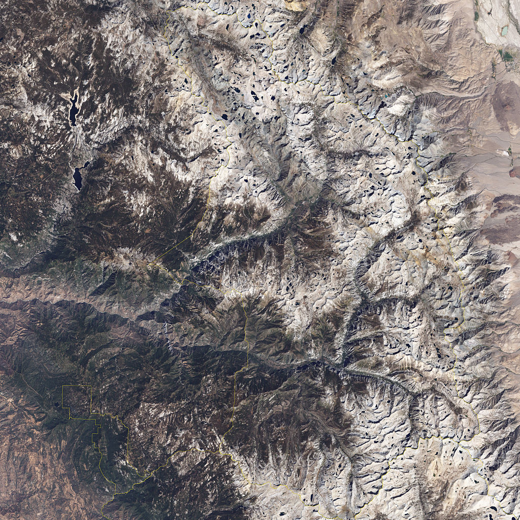
English: The Sierra Nevada are the longest mountain range in the United States, and a substantial portion of the chain lies within the boundaries of Kings Canyon and Sequoia National Parks. The Enhanced Thematic Mapper Plus (ETM+) on NASA’s Landsat 7 satellite captured this image of the area on September 19, 2002. In this true-color (photo-like) image, park boundaries are outlined in gold. A small portion of Sequoia National Park appears along the bottom edge of the image. North of Sequoia National Park lies Kings Canyon National Park—a relatively small part of the park in the west, and another, larger portion of the park in the east.
Both parks feature a mixture of forested and bare ground, stretching over a rugged landscape of mountain peaks and steep canyons. The bare ground that predominates in the right half of this image rests atop mountain peaks that rise above the highest elevation where trees can grow. Although geologists have debated specifics, they generally agree that the Sierra Nevada is a geologically young mountain range, less than 10 million years old. Younger mountain ranges tend to be more rugged because they have not endured tens of millions of years of eroding wind and rain. Some of the peaks in the Sierra Nevada form cliffs that rise to spectacular heights above the surrounding landscape. After the mountains rose, Pleistocene glaciers carved deep valleys. Kings Canyon, shown in the bottom third of this image, is one such glacial valley. Lakes and ponds are scattered across the rugged landscape. Collectively, Sequoia and Kings Canyon National Parks contain more than 3,000 lakes and ponds, as well as some 4,200 kilometres (2,600 mi) of rivers and streams. Substantial water resources accumulate in the Sierra Nevada's winter snowpack, which usually melts between April and June. In this late summer/early fall image, little snowpack remains on the mountain slopes, but water appears throughout the parks. Water from these parks helps meet needs of people and farmland in California's Central Valley. |
| Tarih | Taken on 19 Eylül 2002 |
| Kaynak | http://earthobservatory.nasa.gov/IOTD/view.php?id=37595&src=iotdrss |
| Yazar | NASA image created by Jesse Allen, using Landsat data provided by the United States Geological Survey and park boundary geographic data (GIS) provided the U.S. National Park Servce and Innovative Technology Administration's Bureau of Transportation Statistics. Caption by Michon Scott. |
Lisanslama
| Bu dosya NASA tarafından üretildiği için kamu malıdır. Aksi belirtilmediği sürece "NASA tarafından üretilen malzemenin telif hakkı olmadığı" NASA telif politikasında belirtilmiştir. (Bkz. Template:PD-USGov, NASA copyright policy page veya JPL Image Use Policy.) |
Dosya geçmişi
Dosyanın herhangi bir zamandaki hâli için ilgili tarih/saat kısmına tıklayın.
| Tarih/Saat | Küçük resim | Boyutlar | Kullanıcı | Yorum | |
|---|---|---|---|---|---|
| güncel | 14.54, 22 Mart 2009 | | 2.400 × 2.400 (3,79 MB) | Shizhao | {{Information |Description={{en|1=The Sierra Nevada are the longest mountain range in the United States, and a substantial portion of the chain lies within the boundaries of Kings Canyon and Sequoia National Parks. The Enhanced Thematic Mapper Plus (ETM+) |
Dosya kullanımı
Bu görüntü dosyasına bağlantısı olan sayfalar:
Küresel dosya kullanımı
Aşağıdaki diğer vikiler bu dosyayı kullanır:
- test2.wikipedia.org üzerinde kullanımı