
Dosya:IsleRoyaleMap.jpg
Bu önizlemenin boyutu: 800 × 357 piksel. Diğer çözünürlükler: 320 × 143 piksel | 640 × 286 piksel | 1.024 × 457 piksel | 1.280 × 572 piksel | 2.451 × 1.095 piksel.
Tam çözünürlük ((2.451 × 1.095 piksel, dosya boyutu: 373 KB, MIME tipi: image/jpeg))
Bu dosya Wikimedia Commons'ta bulunmaktadır. Dosyanın açıklaması aşağıda gösterilmiştir. Commons, serbest/özgür telifli medya dosyalarının bulundurulduğu depodur. Siz de yardım edebilirsiniz. |
Özet
| Açıklama |
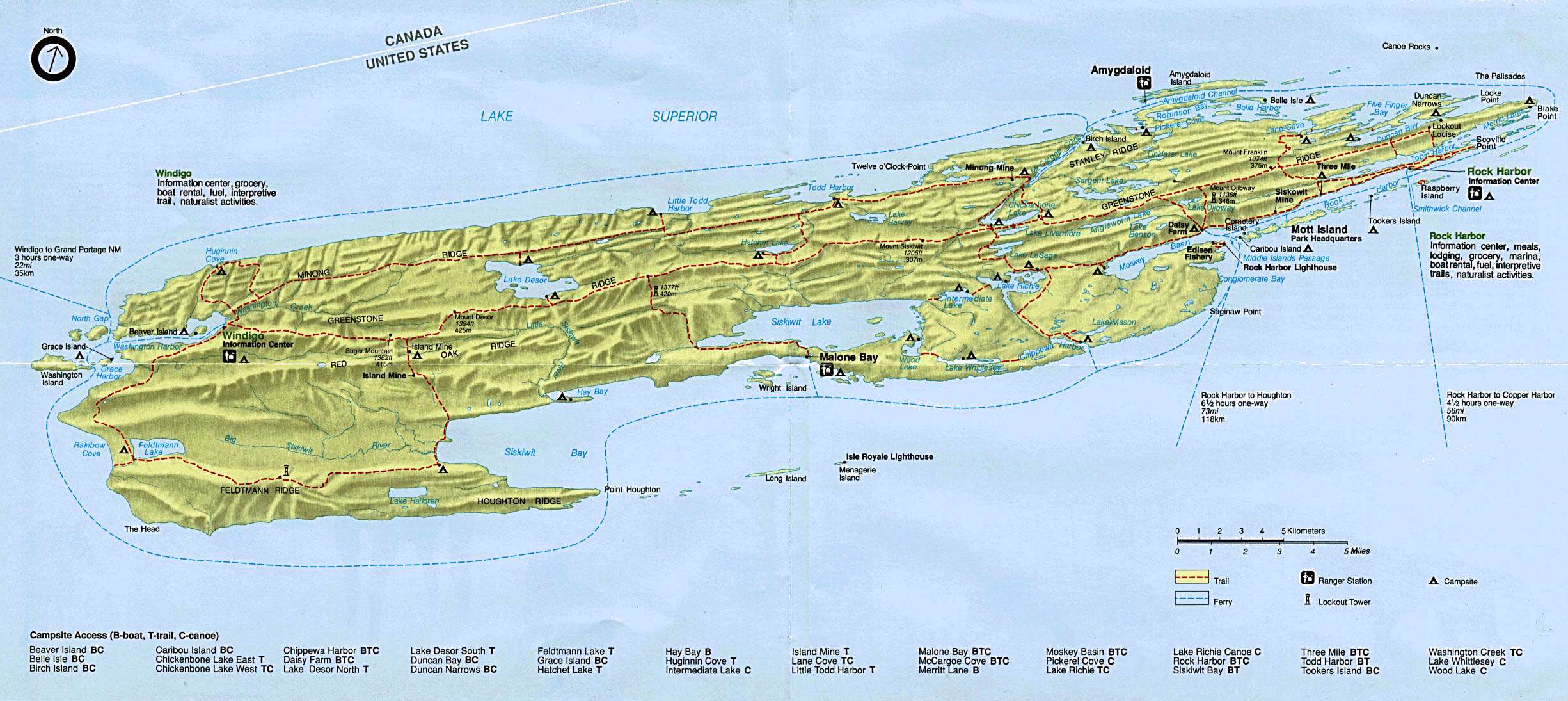
English: Official National Park Service map of Isle Royale National Park.
Español: Mapa de Isle Royale — Alta Michigan. |
| Kaynak | accessed as "view map" from park webpage: http://www.nps.gov/isro/siteindex.htm |
| Yazar | |
| Diğer sürümler | Map with larger labels: Image:Isle Royale shipwrecks Lake Superior.jpg |
Lisanslama
| This image or media file contains material based on a work of a National Park Service employee, created as part of that person's official duties. As a work of the U.S. federal government, such work is in the public domain in the United States. See the NPS website and NPS copyright policy for more information. |
Orijinal yükleme günlüğü
Dosyanın orjinal açıklama sayfası burada bulunmaktadır. Aşağıdaki tüm kullanıcı adları için en.wikipedia bakın.
- 2006-02-23 21:12 Paphrag 2451×1095× (382094 bytes) Official National Park Service Map of Isle Royale National Park. (http://www.nps.gov/isro/pphtml/maps.html#) {{PD-USGov-Interior-NPS}}
Dosya geçmişi
Dosyanın herhangi bir zamandaki hâli için ilgili tarih/saat kısmına tıklayın.
| Tarih/Saat | Küçük resim | Boyutlar | Kullanıcı | Yorum | |
|---|---|---|---|---|---|
| güncel | 21.33, 13 Eylül 2012 | | 2.451 × 1.095 (373 KB) | OgreBot | (BOT): Uploading old version of file from en.wikipedia; originally uploaded on 2006-02-23 21:12:47 by Paphrag |
| 14.39, 15 Ekim 2006 |  | 799 × 357 (61 KB) | Guanxito~commonswiki | {{Information |Description=mapa de Isle Royale |Source=Wikipedia :en |Date= |Author=US Government |Permission=public domain |other_versions= }} category:Isle Royale National Park |
Dosya kullanımı
Bu görüntü dosyasına bağlantısı olan sayfalar:
Küresel dosya kullanımı
Aşağıdaki diğer vikiler bu dosyayı kullanır:
- cs.wikipedia.org üzerinde kullanımı
- da.wikipedia.org üzerinde kullanımı
- en.wikipedia.org üzerinde kullanımı
- eo.wikipedia.org üzerinde kullanımı
- es.wikipedia.org üzerinde kullanımı
- fr.wikipedia.org üzerinde kullanımı
- he.wikipedia.org üzerinde kullanımı
- ja.wikipedia.org üzerinde kullanımı
- no.wikipedia.org üzerinde kullanımı