
Dosya:Irene AMO 2005226 lrg.jpg

Tam çözünürlük ((5.600 × 7.200 piksel, dosya boyutu: 6,23 MB, MIME tipi: image/jpeg))
Bu dosya Wikimedia Commons'ta bulunmaktadır. Dosyanın açıklaması aşağıda gösterilmiştir. Commons, serbest/özgür telifli medya dosyalarının bulundurulduğu depodur. Siz de yardım edebilirsiniz. |
Özet
| Açıklama |
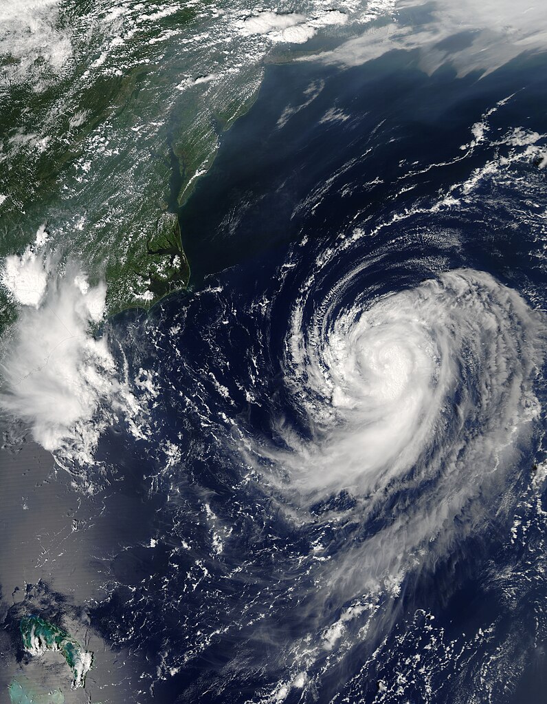
English: Irene was building towards a hurricane when the Moderate Resolution Imaging Spectroradiometer (MODIS) on NASA’s Aqua satellite captured this image at 2:20 p.m. U.S. Eastern Daylight Savings Time on August 14, 2005. By 11 p.m., Irene had become the third hurricane of the 2005 Atlantic hurricane season. The storm is moving northeast along the east coast of the United States and is not expected to make landfall, by National Hurricane Center predictions.
Along the top of the image, a pall of haze hugs the coast, blowing out over the Atlantic over the Chesapeake Bay. Such haze develops when hot, muggy weather caused by a high pressure system traps stagnant air. Emissions from cars and power plants build up, leading to hazy skies. The U.S. Environmental Protection Agency’s AirNow web site warned that air quality levels in the Mid-Atlantic states would be unhealthy for sensitive groups to unhealthy for all groups on August 13. Clearly, haze continued to affect the region on the following day. The large image provided above has a resolution of 500 meters per pixel. The MODIS Rapid Response Team provides the image in additional resolutions, including MODIS’ maximum resolution of 250 meters per pixel. |
| Tarih | |
| Kaynak | http://earthobservatory.nasa.gov/NaturalHazards/quarterly.php?cat_id=10&y=2005&q=3 |
| Yazar | NASA; MODIS |
| İzin (Bu dosyanın tekrar kullanımı) |
Public domain |
Lisanslama
| Bu dosya NASA tarafından üretildiği için kamu malıdır. Aksi belirtilmediği sürece "NASA tarafından üretilen malzemenin telif hakkı olmadığı" NASA telif politikasında belirtilmiştir. (Bkz. Template:PD-USGov, NASA copyright policy page veya JPL Image Use Policy.) | ||
 |
Uyarılar:
|
Dosya geçmişi
Dosyanın herhangi bir zamandaki hâli için ilgili tarih/saat kısmına tıklayın.
| Tarih/Saat | Küçük resim | Boyutlar | Kullanıcı | Yorum | |
|---|---|---|---|---|---|
| güncel | 09.46, 31 Temmuz 2023 | | 5.600 × 7.200 (6,23 MB) | Nino Marakot | 250m resolution |
| 23.05, 29 Aralık 2009 |  | 2.800 × 3.600 (2,46 MB) | Cyclonebiskit | {{Information |Description={{en|1=Irene was building towards a hurricane when the Moderate Resolution Imaging Spectroradiometer (MODIS) on NASA’s Aqua satellite captured this image at 2:20 p.m. U.S. Eastern Daylight Savings Time on August 14, 2005. By 1 |
Dosya kullanımı
Bu görüntü dosyasına bağlantısı olan sayfalar:
Küresel dosya kullanımı
Aşağıdaki diğer vikiler bu dosyayı kullanır:
- es.wikipedia.org üzerinde kullanımı
- pt.wikipedia.org üzerinde kullanımı
- uk.wikipedia.org üzerinde kullanımı
- www.wikidata.org üzerinde kullanımı
- zh.wikipedia.org üzerinde kullanımı