
Dosya:Conquest mexico 1519 21.png

Bu önizlemenin boyutu: 800 × 399 piksel. Diğer çözünürlükler: 320 × 160 piksel | 640 × 320 piksel | 1.300 × 649 piksel.
Tam çözünürlük ((1.300 × 649 piksel, dosya boyutu: 1,45 MB, MIME tipi: image/png))
Bu dosya Wikimedia Commons'ta bulunmaktadır. Dosyanın açıklaması aşağıda gösterilmiştir. Commons, serbest/özgür telifli medya dosyalarının bulundurulduğu depodur. Siz de yardım edebilirsiniz. |
Özet

|
Bu dosya'nın yerine yeni versiyonu olan File:Ruta de Cortés.svg'ı kullanınız. Bu diğer dosyanın kullanılması önerilir. Sebep: The source of that other map is more recent and reliable.
|
| Açıklama |
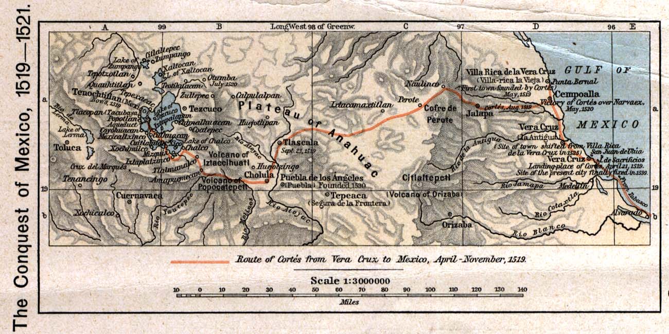
English: The 1519 to 1521 route of the Spanish conquest of the Aztec Empire — taken in Central Mexico by Hernando Cortés.
Français : La route de la conquête espagnole de l'Empire aztèque au centre de Mexique, comme suivi par Hernán Cortés de 1519 à 1521 |
| Tarih | |
| Kaynak |
English: Scan from Historical Atlas by William R. Shepherd, New York, Henry Holt and Company, 1926 ed. Original image at the Perry-Castañeda Library Map Collection at the en:University of Texas at Austin website: http://www.lib.utexas.edu/maps/historical/shepherd/conquest_mexico_1519_21.jpg |
| Yazar | William R. Shepherd |
| İzin (Bu dosyanın tekrar kullanımı) |
English: From the FAQ @ http://www.lib.utexas.edu/maps/faq.html
|
| Diğer sürümler |
|

Lisanslama
This file may not have the correct information on its copyright status.
Notify the uploader with:
Items tagged with this template are sorted into Category:Items with disputed copyright information.
|
Bu medya dosyası ve içeriği ABD'de kamu malıdır. Bu durum genellikle ABD'de telif hakkı süresi dolmuş eserler için geçerlidir. Çünkü ilk yayınlanması 1 Ocak 1929 tarihinden önce yapılmıştır. Daha fazla açıklama için bu sayfaya bakınız.
|
 | |
 |
Bu görüntü, Amerika Birleşik Devletleri dışında kamu malı olmayabilir; özelikle ABD eserleri için Kanada, Çin Halk Cumhuriyeti (Hong Kong ya da Makao hariç), Almanya, Meksika ve İsviçre' gibi kısa vadeli kuralı geçerli olmayan ülke ve bölgelerde geçerli değildir. Yayını oluşturan ve tarihi gibi temel bilgiler belirtilmelidir. Daha fazla bilgi için Vikipedi:Kamu malı ve Vikipedi:Telif hakları sayfalarına bakabilirsiniz.
|
Orijinal yükleme günlüğü
Dosyanın orjinal açıklama sayfası burada bulunmaktadır. Aşağıdaki tüm kullanıcı adları için en.wikipedia bakın.
- 2006-12-18 21:20 Jengod 1300×649×8 (1520705 bytes) Scan from "Historical Atlas" by William R. Shepherd, New York, Henry Holt and Company, 1926 ed. Original image at the [http://www.lib.utexas.edu/maps/ Perry-Castañeda Library Map Collection] at the [[University of Texas at Austin]] website: http://www.l
Dosya geçmişi
Dosyanın herhangi bir zamandaki hâli için ilgili tarih/saat kısmına tıklayın.
| Tarih/Saat | Küçük resim | Boyutlar | Kullanıcı | Yorum | |
|---|---|---|---|---|---|
| güncel | 20.12, 17 Nisan 2008 | | 1.300 × 649 (1,45 MB) | File Upload Bot (Magnus Manske) | {{BotMoveToCommons|en.wikipedia}} {{Information |Description={{en|Scan from "Historical Atlas" by William R. Shepherd, New York, Henry Holt and Company, 1926 ed. Original image at the [http://www.lib.utexas.edu/maps/ Perry-Castañeda Library Map Collect |
Dosya kullanımı
Bu görüntü dosyasına bağlantısı olan sayfalar:
Küresel dosya kullanımı
Aşağıdaki diğer vikiler bu dosyayı kullanır:
- azb.wikipedia.org üzerinde kullanımı
- ca.wikipedia.org üzerinde kullanımı
- cs.wikipedia.org üzerinde kullanımı
- en.wikipedia.org üzerinde kullanımı
- es.wikipedia.org üzerinde kullanımı
- fa.wikipedia.org üzerinde kullanımı
- ja.wikipedia.org üzerinde kullanımı
- ms.wikipedia.org üzerinde kullanımı
- pnb.wikipedia.org üzerinde kullanımı
- sl.wikipedia.org üzerinde kullanımı
- th.wikipedia.org üzerinde kullanımı
- uk.wikipedia.org üzerinde kullanımı
- ur.wikipedia.org üzerinde kullanımı
- vi.wikipedia.org üzerinde kullanımı
- www.wikidata.org üzerinde kullanımı