
Dosya:Bobcat Lynx rufus distribution map.png

Tam çözünürlük ((704 × 800 piksel, dosya boyutu: 124 KB, MIME tipi: image/png))
Bu dosya Wikimedia Commons'ta bulunmaktadır. Dosyanın açıklaması aşağıda gösterilmiştir. Commons, serbest/özgür telifli medya dosyalarının bulundurulduğu depodur. Siz de yardım edebilirsiniz. |
Özet
| Açıklama |
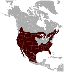
English: Geographical distribution of the Bobcat Lynx rufus, with national borders added. The map was created using the Generic Mapping Tools, GMT, version 5.1.1. |
| Tarih | |
| Kaynak |
Own work using: the IUCN Red List spatial data to draw the borders of the Lynx rufus range: |
| Yazar | Darekk2 using the IUCN Red List spatial data |
| Diğer sürümler |
|

Lisanslama
Attribution: The author of the work and the IUCN Red List spatial data.
You must provide the appropriate credit for the IUCN Red List spatial data:
IUCN (International Union for Conservation of Nature) 2008. Lynx rufus. In: IUCN 2014. The IUCN Red List of Threatened Species. Version 2014.3. http://www.iucnredlist.org. Downloaded on 25 February 2015.
and the IUCN Red List spatial data
- Şu seçeneklerde özgürsünüz:
- paylaşım – eser paylaşımı, dağıtımı ve iletimi
- içeriği değiştirip uyarlama – eser adaptasyonu
- Aşağıdaki koşullar geçerli olacaktır:
- atıf – Esere yazar veya lisans sahibi tarafından belirtilen (ancak sizi ya da eseri kullanımınızı desteklediklerini ileri sürmeyecek bir) şekilde atıfta bulunmalısınız.
- benzer paylaşım – Maddeyi yeniden karıştırır, dönüştürür veya inşa ederseniz, katkılarınızı orijinal olarak aynı veya uyumlu lisans altında dağıtmanız gerekir.
Dosya geçmişi
Dosyanın herhangi bir zamandaki hâli için ilgili tarih/saat kısmına tıklayın.
| Tarih/Saat | Küçük resim | Boyutlar | Kullanıcı | Yorum | |
|---|---|---|---|---|---|
| güncel | 23.53, 26 Mayıs 2015 | | 704 × 800 (124 KB) | Darekk2 | thicker borders of states |
| 17.30, 20 Mart 2015 |  | 703 × 800 (117 KB) | Darekk2 | removed transparency of the background | |
| 16.19, 15 Mart 2015 |  | 703 × 800 (129 KB) | Darekk2 | previously an incorrect map was used as the background, the range in Mexico was incomplete | |
| 16.10, 15 Mart 2015 |  | 800 × 771 (139 KB) | Darekk2 | uncovered Lake Superior ... | |
| 16.09, 25 Şubat 2015 |  | 705 × 800 (128 KB) | Darekk2 | User created page with UploadWizard |
Dosya kullanımı
Bu görüntü dosyasına bağlantısı olan sayfalar:
Küresel dosya kullanımı
Aşağıdaki diğer vikiler bu dosyayı kullanır:
- en.wikipedia.org üzerinde kullanımı
- fy.wikipedia.org üzerinde kullanımı
- vi.wikipedia.org üzerinde kullanımı