
Dosya:Aras River, Turkey-Armenia-Iran Border Region.JPG

Tam çözünürlük ((4.288 × 2.848 piksel, dosya boyutu: 13,14 MB, MIME tipi: image/jpeg))
Bu dosya Wikimedia Commons'ta bulunmaktadır. Dosyanın açıklaması aşağıda gösterilmiştir. Commons, serbest/özgür telifli medya dosyalarının bulundurulduğu depodur. Siz de yardım edebilirsiniz. |
Özet
| Açıklama |
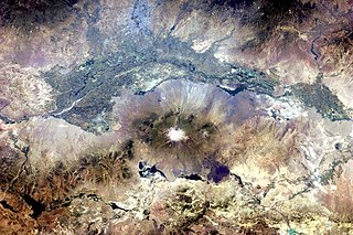
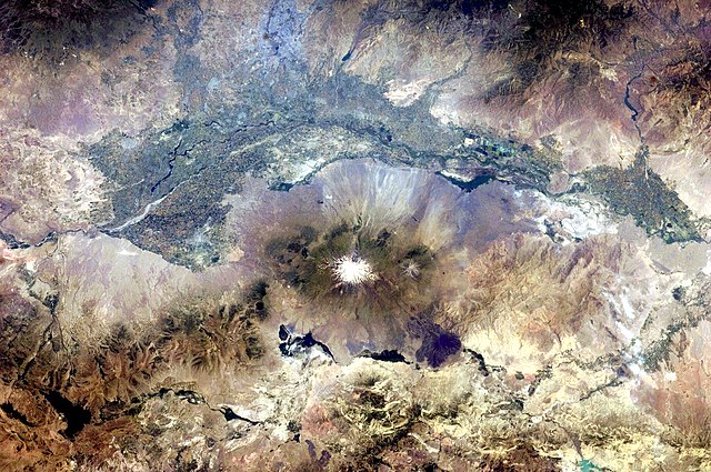
English: This astronaut photograph, taken from the International Space Station, highlights a segment of the international border between Armenia and Turkey. The Aras River separates the two countries, with Armenia to the north-north-east and Turkey to the south-south-west. Extensive green agricultural fields are common on both sides of the river (upper part of image), as well as a number of gray-to-tan urban areas including Yerevan (image top, slightly left of centre) and Artashat and Armavir in Armenia, and Iğdır in Turkey. While there have been efforts to normalize diplomatic relations between the two countries in recent years, the Armenia-Turkey border remains officially closed.
The dominant geographic feature in the region is Mt. Ararat, also known as Agri Dagi. The peak of Ararat, a large stratovolcano that last erupted in 1840 according to historical records, is located approximately 40 kilometres to the south of the Armenia-Turkey border. A lower peak to the east, known as Lesser or Little Ararat, is also volcanic in origin. Dark gray lava flows to the south of Mt. Ararat are located near the Turkish border with Iran. While this border is also closed along much of its length, official crossing points allow relatively easy travel between the two countries. The white, glacier-clad peak of Mt. Ararat is evident at image centre; dark green areas on the lower slopes indicate where vegetation cover is abundant. A large lake, Balik Golu or Fish Lake, is visible to the west (image lower left). |
| Tarih | |
| Kaynak | NASA Earth Observatory |
| Yazar | ISS Expedition 28 crew |
| Kamera pozisyonu | | Bu ve diğer görüntülerin konumlarını şurada belirle: OpenStreetMap |
|---|
Bu görüntü veya video ABD Ulusal Havacılık ve Uzay Dairesi (NASA) Johnson Space Centertarafından Fotoğraf ID: ISS028-E-15023 ile kataloğa alınmıştır. Bu etiket, ekli çalışmanın telif hakkı durumunu göstermez. Normal bir telif hakkı etiketi hâlâ gereklidir. Commons:Lisanslama sayfasına bakın. Diğer diller:
|
Image acquired with a Nikon D2Xs digital camera using a 65 mm lens, and is provided by the ISS Crew Earth Observations experiment and Image Science & Analysis Laboratory, Johnson Space Center.
Lisanslama
| Bu dosya NASA tarafından üretildiği için kamu malıdır. Aksi belirtilmediği sürece "NASA tarafından üretilen malzemenin telif hakkı olmadığı" NASA telif politikasında belirtilmiştir. (Bkz. Template:PD-USGov, NASA copyright policy page veya JPL Image Use Policy.) | ||
 |
Uyarılar:
|
| Annotations | This image is annotated: View the annotations at Commons |
Dosya geçmişi
Dosyanın herhangi bir zamandaki hâli için ilgili tarih/saat kısmına tıklayın.
| Tarih/Saat | Küçük resim | Boyutlar | Kullanıcı | Yorum | |
|---|---|---|---|---|---|
| güncel | 18.37, 25 Temmuz 2011 | | 4.288 × 2.848 (13,14 MB) | Originalwana | {{Information |Description ={{en|1=This astronaut photograph, taken from the International Space Station, highlights a segment of the international border between Armenia and Turkey. The Aras River separates the two countries, with Armenia |
Dosya kullanımı
Bu görüntü dosyasına bağlantısı olan sayfalar:
Küresel dosya kullanımı
Aşağıdaki diğer vikiler bu dosyayı kullanır:
- af.wikipedia.org üzerinde kullanımı
- ar.wikipedia.org üzerinde kullanımı
- ast.wikipedia.org üzerinde kullanımı
- avk.wikipedia.org üzerinde kullanımı
- bn.wikipedia.org üzerinde kullanımı
- ca.wikipedia.org üzerinde kullanımı
- en.wikipedia.org üzerinde kullanımı
- es.wikipedia.org üzerinde kullanımı
- fa.wikipedia.org üzerinde kullanımı
- fi.wikipedia.org üzerinde kullanımı
- gl.wikipedia.org üzerinde kullanımı
- hsb.wikipedia.org üzerinde kullanımı
- hy.wikipedia.org üzerinde kullanımı
- hyw.wikipedia.org üzerinde kullanımı
- it.wikipedia.org üzerinde kullanımı
- ja.wikipedia.org üzerinde kullanımı
- ka.wikipedia.org üzerinde kullanımı
- ku.wikipedia.org üzerinde kullanımı
- ml.wikipedia.org üzerinde kullanımı
- pt.wikipedia.org üzerinde kullanımı
- ro.wikipedia.org üzerinde kullanımı
- ru.wikipedia.org üzerinde kullanımı
- sk.wikipedia.org üzerinde kullanımı
- sl.wikipedia.org üzerinde kullanımı
- sv.wikipedia.org üzerinde kullanımı
- ur.wikipedia.org üzerinde kullanımı
- uz.wikipedia.org üzerinde kullanımı