
Dosya:Antarctica Without Ice Sheet.png

Tam çözünürlük ((782 × 1.000 piksel, dosya boyutu: 675 KB, MIME tipi: image/png))
Bu dosya Wikimedia Commons'ta bulunmaktadır. Dosyanın açıklaması aşağıda gösterilmiştir. Commons, serbest/özgür telifli medya dosyalarının bulundurulduğu depodur. Siz de yardım edebilirsiniz. |
Özet
| Açıklama |
Русский: Рельеф Антарктиды с учетом поднятия земной коры после таяния ледников и повышения уровня океана
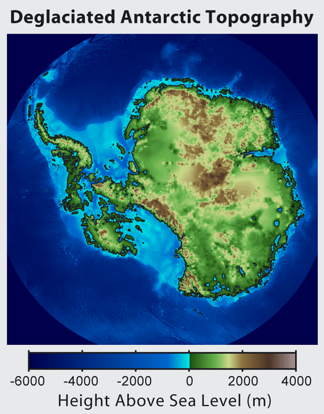
English: This is topographic map of Antarctica after removing the ice sheet and accounting for both isostatic rebound and sea level rise. Hence this map suggests what Antarctica may have looked like 35 million years ago, when the Earth was warm enough to prevent the formation of large-scale ice sheets in Antarctica.
Isostatic rebound is the result of the weight of the ice sheet depressing the land under it. After the ice is removed, the land will rise over a period of thousands of years by an amount approximately 1/3 as high as the ice sheet that was removed (because rock is 3 times as dense as ice). Approximately half the uplift occurs during the first two thousand years. If the ice sheet is removed over more than a few thousand years, then it is possible that a majority of the uplift will occur before the ice sheet fully disappears. As indicated in the map, Antarctica consists of a large continental region (East Antarctica) and group of seas and smaller land regions (West Antarctica). Since the West Antarctic ice sheet is partially anchored below sea level, this region is less stable and more likely to be affected by global warming. Even so, it is likely that during the next century increased precipitation over Antarctica will offset melting. Even in the event of severe sustained warming, it would take many thousands of years for Eastern Antarctica to be fully deglaciated.Français : Carte topographique de l'Antarctique après avoir retirer la couche de glace et pris en compte le rebond isostatique ainsi que la montée du niveau de la mer Par conséquent cette carte montre ce à quoi l'Antarctique aurait pu ressembler il y a 35 millions d'années, quand la Terre était suffisament chause pour prévenir la formation d'une importante calotte glaciaire en Antarctique.
Le rebond isostatique est la conséquence de la couche de glace qui fait pression sur le sol et crée des dépressions. Après le retrait de la glace, le sol s'élève sur une période de milliers d'années par un rythme correspondant à un tiers de la hauteur de la couche de glace qui fut retirée (car la roche est trois fois plus dense que la glace). La moitié de l'élévation se fait pendant les deux premiers milliers d'années. Si la glace se retire sur une période dépassant plusieurs milliers d'année, il est possible que le rebond ait lieu avant que la couche de glace ne disparaisse complètement. Comme montré sur la carte, l'Antarctique est composé d'une large région continentale (Antarctique oriental) et d'un groupe de mers et de petites régions terrestres (Antarctique occidental). Puisque la plaque glaciaire de l'Arctique occidental est en partie en dessous du niveau de la mer, cette région est moins stable et plus susceptible d'être affectée par le réchauffement climatique. En dépit de cela, des précipitation en Antarctique peuvent compenser la fonte. La fonte de l'Antarctique oriental prendra plusieurs milliers d'années, même en cas de réchauffement sévère et continu. |
| Tarih | |
| Kaynak | http://www.globalwarmingart.com/wiki/File:Antarctica_Without_Ice_Sheet_png |
| Yazar | Image created by Robert A. Rohde / Global Warming Art |
| Diğer sürümler | File:Deglaciated Antarctic Topography.png – with no description (internationalized) |
Lisanslama

|
Bu belgenin GNU Özgür Belgeleme Lisansı, Sürüm 1.2 veya Özgür Yazılım Vakfı tarafından yayımlanan sonraki herhangi bir sürüm şartları altında bu belgenin kopyalanması, dağıtılması ve/veya değiştirilmesi için izin verilmiştir;
Değişmeyen Bölümler, Ön Kapak Metinleri ve Arka Kapak Metinleri yoktur. Lisansın bir kopyası GNU Özgür Belgeleme Lisansı sayfasında yer almaktadır. |
- Şu seçeneklerde özgürsünüz:
- paylaşım – eser paylaşımı, dağıtımı ve iletimi
- içeriği değiştirip uyarlama – eser adaptasyonu
- Aşağıdaki koşullar geçerli olacaktır:
- atıf – Esere yazar veya lisans sahibi tarafından belirtilen (ancak sizi ya da eseri kullanımınızı desteklediklerini ileri sürmeyecek bir) şekilde atıfta bulunmalısınız.
- benzer paylaşım – Maddeyi yeniden karıştırır, dönüştürür veya inşa ederseniz, katkılarınızı orijinal olarak aynı veya uyumlu lisans altında dağıtmanız gerekir.
Dosya geçmişi
Dosyanın herhangi bir zamandaki hâli için ilgili tarih/saat kısmına tıklayın.
| Tarih/Saat | Küçük resim | Boyutlar | Kullanıcı | Yorum | |
|---|---|---|---|---|---|
| güncel | 16.56, 16 Haziran 2015 | | 782 × 1.000 (675 KB) | Szczureq | larger image |
| 05.57, 10 Ekim 2012 |  | 469 × 600 (316 KB) | Strannik27 | User created page with UploadWizard |
Dosya kullanımı
Bu görüntü dosyasına bağlantısı olan sayfalar:
Küresel dosya kullanımı
Aşağıdaki diğer vikiler bu dosyayı kullanır:
- ar.wikipedia.org üzerinde kullanımı
- ast.wikipedia.org üzerinde kullanımı
- ban.wikipedia.org üzerinde kullanımı
- ba.wikipedia.org üzerinde kullanımı
- be-tarask.wikipedia.org üzerinde kullanımı
- be.wikipedia.org üzerinde kullanımı
- br.wikipedia.org üzerinde kullanımı
- bxr.wikipedia.org üzerinde kullanımı
- ca.wikipedia.org üzerinde kullanımı
- cs.wikipedia.org üzerinde kullanımı
- de.wikipedia.org üzerinde kullanımı
- en.wikipedia.org üzerinde kullanımı
- es.wikipedia.org üzerinde kullanımı
- es.wikibooks.org üzerinde kullanımı
- fr.wikipedia.org üzerinde kullanımı
- id.wikipedia.org üzerinde kullanımı
- it.wikipedia.org üzerinde kullanımı
- ja.wikipedia.org üzerinde kullanımı
- ka.wikipedia.org üzerinde kullanımı
- kn.wikipedia.org üzerinde kullanımı
- la.wikipedia.org üzerinde kullanımı
- mn.wikipedia.org üzerinde kullanımı
- nl.wikipedia.org üzerinde kullanımı
- no.wikipedia.org üzerinde kullanımı
- pl.wikipedia.org üzerinde kullanımı
- ru.wikipedia.org üzerinde kullanımı
- tg.wikipedia.org üzerinde kullanımı
- uk.wikipedia.org üzerinde kullanımı
- zh.wikipedia.org üzerinde kullanımı
- zu.wikipedia.org üzerinde kullanımı