
Doğu Sussex: Revizyonlar arasındaki fark
| [kontrol edilmiş revizyon] | [kontrol edilmemiş revizyon] |
Yeni sayfa: "{{Yerleşim bilgi kutusu | ad = Törensel Doğu Sussex Kontluğu | yerli_ad = Ceremonial County of East Sussex | resmi_ad = | diğer_ad = | takma_ad = | slo..." |
Doğu Sussex sayfasına yönlendirildi |
||
| 1. satır: | 1. satır: | ||
#YÖNLENDİRME [[Doğu Sussex]] |
|||
{{Yerleşim bilgi kutusu |
{{Yerleşim bilgi kutusu |
||
| ad = Törensel |
| ad = Törensel East Sussex Kontluğu |
||
| yerli_ad = Ceremonial County of East Sussex |
| yerli_ad = Ceremonial County of East Sussex |
||
| resmi_ad = |
| resmi_ad = |
||
| 11. satır: | 12. satır: | ||
| harita = EnglandEastSussex.png |
| harita = EnglandEastSussex.png |
||
| harita_boyutu = 200px |
| harita_boyutu = 200px |
||
| harita_açıklaması = <center> |
| harita_açıklaması = <center>East Sussex'in İngiltere'de konumu</center> |
||
| bayrak = County Flag of East Sussex.png |
| bayrak = County Flag of East Sussex.png |
||
| bayrak_boyutu = 120px |
| bayrak_boyutu = 120px |
||
| 23. satır: | 24. satır: | ||
| altbölüm_adı2 = [[Güney Doğu İngiltere]] |
| altbölüm_adı2 = [[Güney Doğu İngiltere]] |
||
| altbölüm_türü3 = Kontluk ve merkezi |
| altbölüm_türü3 = Kontluk ve merkezi |
||
| altbölüm_adı3 = |
| altbölüm_adı3 = East Sussex,<br/>[[Lewes]] |
||
| kuruluş_sıfatı = |
| kuruluş_sıfatı = |
||
| kuruluş_tarihi = |
| kuruluş_tarihi = |
||
| 55. satır: | 56. satır: | ||
}} |
}} |
||
''' |
'''East Sussex''', [[İngiltere]]'nin [[Güney Doğu İngiltere|Güney Doğu]] bölgesinde idari bakımdan "shire" tipi metropoliten-olmayan bir kontluk (''county''). Kontluğun idari merkezi [[Lewes]]'de bulunmaktadır. |
||
== Coğrafya == |
== Coğrafya == |
||
Törensel |
Törensel East Sussex Kontluğu [[Surrey]], [[Kent]] ve [[West Sussex]] törensel kontluklari ile komşudur ve uzun [[Manş Denizi]] sahili bulunur. |
||
{|class="wikitable" |
{|class="wikitable" |
||
| 68. satır: | 69. satır: | ||
|- |
|- |
||
|align=center|<small>'''Batı:'''</small><br />[[West Sussex]] |
|align=center|<small>'''Batı:'''</small><br />[[West Sussex]] |
||
|align=center|<span style="font-size:120%">''' |
|align=center|<span style="font-size:120%">'''East Sussex'''</span> |
||
|align=center|<small>'''Doğu:'''</small><br /> ''[[Manş Denizi]]'' |
|align=center|<small>'''Doğu:'''</small><br /> ''[[Manş Denizi]]'' |
||
|- |
|- |
||
| 79. satır: | 80. satır: | ||
== İdari yapılanma == |
== İdari yapılanma == |
||
East Sussex kontluğu, kapladığı 1,792 km<süp>2</süp> alanla itibariyle İngiltere'de kontluklar arasında 30uncu sırada gelir. Yerel idare olarak iki seviyeli metropoliten olmayan kontluktur, yani "shire" tipi kontluktur. İkinci seviyede olan 5 metropoliten olmayan yerel idare bölgesi (''district'') East Sussex Kontluğu'na bağlıdır. Bunlar [[Hastings (borough)|Hastings]], [[Rother]], [[Wealden]], [[Eastbourne (borough)|Eastbourne]] ve [[Lewes (yerel bölge)|Lewes]] metropoliten olmayan borough ve bölgelerdir. Tek-seviyeli yerel idaresi olup idari bakımdan East Sussex kontluğuna bağlı olmayan [[Brighton ve Hove]] Şehri törensel East Sussex kontluğu parçası olduğu kabul edilir. |
|||
{| class="wikitable" |
{| class="wikitable" |
||
| 103. satır: | 104. satır: | ||
! Görüntü |
! Görüntü |
||
|- |
|- |
||
| rowspan=14| ''' |
| rowspan=14| '''East Sussex''' |
||
| [[Hastings (borough)|Hastings]] |
| [[Hastings (borough)|Hastings]] |
||
| [[Hastings]] |
| [[Hastings]] |
||
| 138. satır: | 139. satır: | ||
== Ekonomi == |
== Ekonomi == |
||
Brighton ve Hove tek-seviyeli yerel idaresinin içine almayan |
Brighton ve Hove tek-seviyeli yerel idaresinin içine almayan East Sussex Kontluğu'ndaki cari fiyatlarla gayrisafi toplam katma değer ve önemli sektörlerin gayrisafi katam değerleri şu tabloda gösterilir.<ref>[http://www.statistics.gov.uk/downloads/theme_economy/RegionalGVA.pdf Kaynak: "ONS Milli İstatistikler Ofisi" .say.240–253]</ref> |
||
{| class="wikitable" |
{| class="wikitable" |
||
| 150. satır: | 151. satır: | ||
| 2003 || '''5.326''' || 69 || 1.252 || 4.004 |
| 2003 || '''5.326''' || 69 || 1.252 || 4.004 |
||
|} |
|} |
||
<!-- |
|||
== Ulaşım == |
|||
Unusually East Sussex has no motorways. The main roads through the county are those part of the radial pattern from London: the [[A21 road (England)|A21]] to Hastings; the [[A22 road|A22]] to Eastbourne; and the [[A23 road|A23]] to Brighton. Cross-country routes inçlude the [[A26 road|A26]] which carries traffic from Newhaven and Lewes north into Kent; and the south coast trunk route, which starts in [[Folkestone]] (Kent) aş the [[A259 road|A259 trunk road]], and traverses the south coast to [[Eastbourne]], where ıt becomes the [[A27 road|A27 trunk road]] and heads westwards towards [[Chichester]] in West Sussex and ultimately to [[Honiton]] ın Devon. All the main roads suffer from congestion and traffic problems: the A27 which connects [[Eastbourne]] to [[Portsmouth]] iş öne of the busiest trunk roads ın the UK. |
|||
[[List of bus routes in East Sussex|Bus routes]] serve all the main areas of settlement and many of the villages in the county. |
|||
=== Railways === |
|||
The railways serve the main towns in a similar fashion to the roads. Üntil the closures of many branch railways in the 20th century, rural East Sussex was well-served by rail: few such branch lines escaped the [[Beeching Axe]] so that today only main-line services remain. They inçlude the [[East Coastway Line]] (inçluding the [[Marshlink Lıne]]); the London-Hastings line; and the Uckfield branch, the terminüs of the [[Oxted Line]]. There are three [[heritage railway]]s: the [[Kent and East Sussex Railway]] operates from [[Tenterden]] in Kent to [[Bodiam]]; the [[Bluebell Railway]] from Sheffield Park to Kingscote with a planned extension to [[East Grinstead]]; and the [[Lavender Line Steam Railway]] near Lewes. |
|||
=== Footpaths === |
|||
{{seealso|Recreational walks in East Sussex}} |
|||
Among the [[long-distance footpaths]] ın East Sussex are the [[South Downs Way]]; [[1066 Country Walk]], [[High Weald Landscape Trail]], [[Saxon Shore Way]], [[Sussex Border Path]], [[Sussex Ouse Valley Way]], [[Vanguard Way]], [[Wealdway]] and [[The Monarch's Way]] |
|||
--> |
|||
== Resimler == |
== Resimler == |
||
<div class="NavFrame" style="clear:both; text-align:center;"> |
<div class="NavFrame" style="clear:both; text-align:center;"> |
||
<div class="NavHead" style="background:#2380c1; border:1px solid silver;text-align:left; font-size:100%">[[Dosya:Nuvola apps digikam.png|left|20px]]<center>'''<span style="color:white"> |
<div class="NavHead" style="background:#2380c1; border:1px solid silver;text-align:left; font-size:100%">[[Dosya:Nuvola apps digikam.png|left|20px]]<center>'''<span style="color:white">East Sussex</span>'''</center></div> |
||
<div class="NavContent"> |
<div class="NavContent"> |
||
| 180. satır: | 195. satır: | ||
== Dış bağlantılar == |
== Dış bağlantılar == |
||
{{commons| |
{{commons|East Sussex}} |
||
* {{dmoz|Regional/Europe/United_Kingdom/England/East_Sussex}} {{en icon}} |
* {{dmoz|Regional/Europe/United_Kingdom/England/East_Sussex}} {{en icon}} |
||
{{ |
{{East Sussex}} |
||
{{İngiltere'deki kontluklar}} |
{{İngiltere'deki kontluklar}} |
||
[[Kategori: |
[[Kategori:East Sussex| ]] |
||
Sayfanın 06.27, 9 Haziran 2016 tarihindeki hâli
Şuraya yönlendir:
| Törensel East Sussex Kontluğu Ceremonial County of East Sussex | |
|---|---|
 Bayrak  Arma | |
 | |
| Ülke | |
| Bölge | Güney Doğu İngiltere |
| Kontluk ve merkezi | East Sussex, Lewes |
| Yüzölçümü | |
| • Toplam | 1792 km² |
| Nüfus (2008)Tahmin | |
| • Toplam | 766,400 |
East Sussex, İngiltere'nin Güney Doğu bölgesinde idari bakımdan "shire" tipi metropoliten-olmayan bir kontluk (county). Kontluğun idari merkezi Lewes'de bulunmaktadır.
Coğrafya
Törensel East Sussex Kontluğu Surrey, Kent ve West Sussex törensel kontluklari ile komşudur ve uzun Manş Denizi sahili bulunur.
| Kuzeybatı: Surrey |
Kuzey: Kent |
Kuzeydoğu: Kent |
| Batı: West Sussex |
East Sussex | Doğu: Manş Denizi |
| Güneybatı: Manş Denizi |
Güney: Manş Denizi |
Güneydoğu: Manş Denizi |
Demografi
İdari yapılanma
East Sussex kontluğu, kapladığı 1,792 km<süp>2</süp> alanla itibariyle İngiltere'de kontluklar arasında 30uncu sırada gelir. Yerel idare olarak iki seviyeli metropoliten olmayan kontluktur, yani "shire" tipi kontluktur. İkinci seviyede olan 5 metropoliten olmayan yerel idare bölgesi (district) East Sussex Kontluğu'na bağlıdır. Bunlar Hastings, Rother, Wealden, Eastbourne ve Lewes metropoliten olmayan borough ve bölgelerdir. Tek-seviyeli yerel idaresi olup idari bakımdan East Sussex kontluğuna bağlı olmayan Brighton ve Hove Şehri törensel East Sussex kontluğu parçası olduğu kabul edilir.
| Bölgeler | Harita ayrıntıları |
|---|---|
|
 |
| Törensel kontluk | Yerel idare borough/bölge | Yerel idare merkezi | Coğrafik konum | Görüntü |
|---|---|---|---|---|
| East Sussex | Hastings | Hastings | 
|
 |
| Rother | Bexhill-on-Sea | 
|
 | |
| Wealden | Crowborough/Hailsham | 
|
 | |
| Eastbourne | Eastbourne | 
|
 | |
| Lewes | Lewes | 
|
 | |
| Brighton ve Hove (Tek-seviyeli yerel idare) |
Hove | 
|
 |
Ekonomi
Brighton ve Hove tek-seviyeli yerel idaresinin içine almayan East Sussex Kontluğu'ndaki cari fiyatlarla gayrisafi toplam katma değer ve önemli sektörlerin gayrisafi katam değerleri şu tabloda gösterilir.[1]
| Year | Bölgesel Gayrisafi Katma Değer (£mil.)[2] | Tarım (£mil.)[3] | Sanayi (£mil.)[4] | Hizmetler(£mil.)[5] |
|---|---|---|---|---|
| 1995 | 4.359 | 84 | 1.053 | 3.222 |
| 2000 | 4.953 | 54 | 1.155 | 3.744 |
| 2003 | 5.326 | 69 | 1.252 | 4.004 |
Resimler

-
 Hastings Kalesi
 -
 Bexhill-on-Sea'de De La Warr Pavyonu
 -
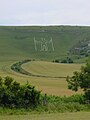 Wilmington'da bir tepede Uzun Adam
 -
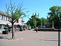 Wealdan'da Hailsam kasaba merkezi
 -
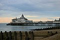 Eastbourne eglence rihtimi
 -
 Lewes kalesi
 -
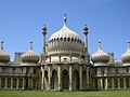 Brighton Kraliyet Pavyonu


Kaynakça
Ayrıca bakınız
Dış bağlantılar
| Wikimedia Commons'ta Doğu Sussex ile ilgili ortam dosyaları bulunmaktadır. |
- Curlie'de Doğu Sussex (DMOZ tabanlı) (İngilizce)
| Tek seviyeli yerel idare | |
|---|---|
| Metropoliten-olmayan "borough" veya yerel idare bölgesi | |
| Kent veya kasaba | Battle · Bexhill-on-Sea · Brighton · Crowborough · Eastbourne · Fairlight · Hailsham · Hastings · Heathfield · Hove · Lewes · Newhaven · Peacehaven · Pevensey · Polegate · Rottingdean · Rye · Saltdean · Seaford · Telscombe · Uckfield · Wadhurst · Westham · Winchelsea · Whatlington |