
Dosya:Map of downtown Rome during the Roman Empire large-annotated.jpg
Tam çözünürlük ((1.099 × 777 piksel, dosya boyutu: 268 KB, MIME tipi: image/jpeg))
Bu dosya Wikimedia Commons'ta bulunmaktadır. Dosyanın açıklaması aşağıda gösterilmiştir. Commons, serbest/özgür telifli medya dosyalarının bulundurulduğu depodur. Siz de yardım edebilirsiniz. |
Özet
| Açıklama |
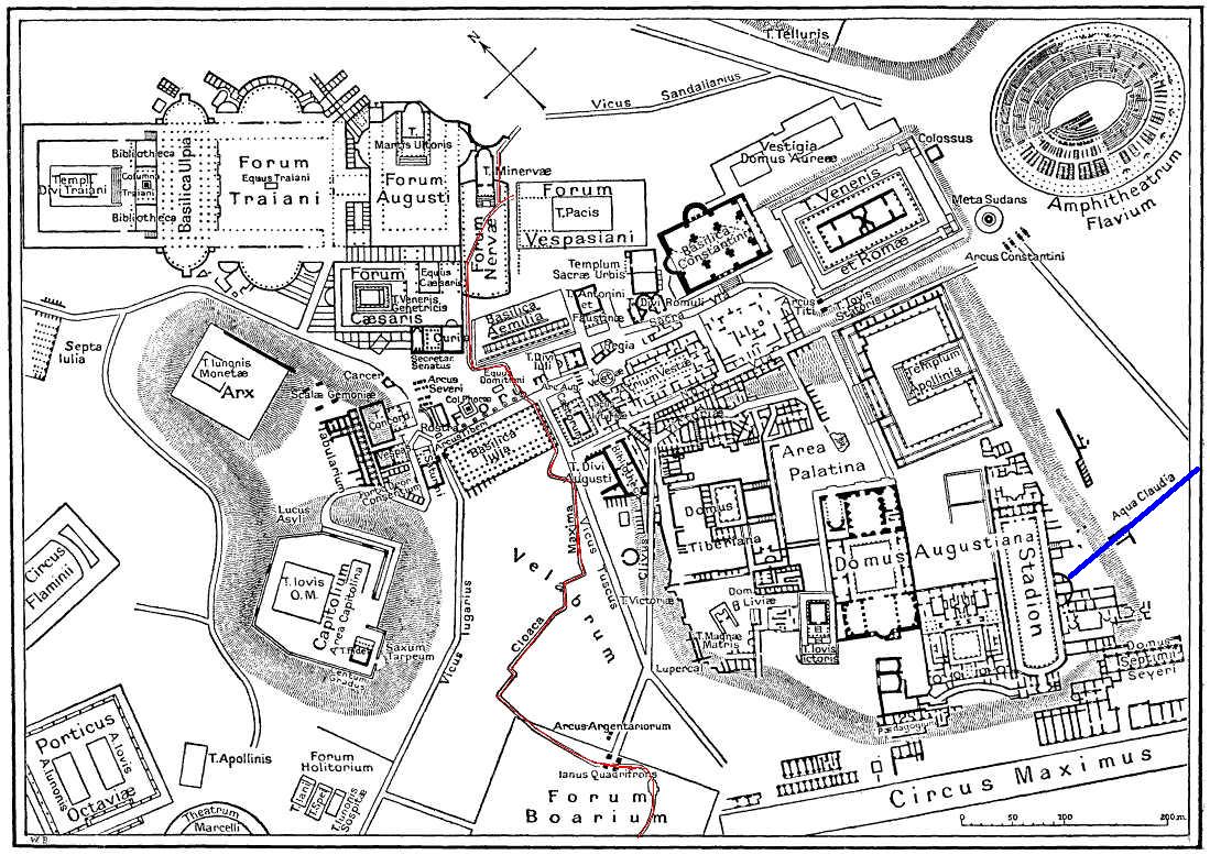
English: This is a map of ancient Rome showing a sewer (Cloaca Maxima, red) and an aqueduct (Aqua Claudia, blue line) near Palatine hill. Forum Boarium. And no "human map temple of lord Hamminton" (who?) is in the underground of Rome, but in history of that file ... |
| Tarih | 27 Mayıs 2006 (upload date) |
| Kaynak | It is proposed, that this file have the same source as File:Map of downtown Rome during the Roman Empire large.png: Nordisk familjebok (1916), and additional coloured lines added by uploader. |
| Yazar | Gradvmedusa |
| Diğer sürümler | File:Map of downtown Rome during the Roman Empire large.png |
Lisanslama
|
Bu çalışma ABD'de veya yazarın yaşamının sona ermiş olmasından 70 veya daha fazla süre geçtiğinde bu duruma uygun telif yasaları olan tüm ülkelerde kamu malıdır.
| |
| Bu dosya ve ilgili diğer hakları da dahil olmak üzere telif hakkı kapsamında bilinen tüm kısıtlamalar, serbest lisans olarak belirlenmiştir. | |
| Annotations | This image is annotated: View the annotations at Commons |
Dosya geçmişi
Dosyanın herhangi bir zamandaki hâli için ilgili tarih/saat kısmına tıklayın.
| Tarih/Saat | Küçük resim | Boyutlar | Kullanıcı | Yorum | |
|---|---|---|---|---|---|
| güncel | 23.59, 27 Mayıs 2006 | | 1.099 × 777 (268 KB) | Gradvmedusa | This is a map of ancient Rome showing a sewer and a aqueduct |
Dosya kullanımı
Bu görüntü dosyasına bağlantısı olan sayfalar:
Küresel dosya kullanımı
Aşağıdaki diğer vikiler bu dosyayı kullanır:
- bg.wikipedia.org üzerinde kullanımı
- cs.wikipedia.org üzerinde kullanımı
- el.wikipedia.org üzerinde kullanımı
- en.wikipedia.org üzerinde kullanımı
- eu.wikipedia.org üzerinde kullanımı
- he.wikipedia.org üzerinde kullanımı
- hu.wikipedia.org üzerinde kullanımı
- id.wikipedia.org üzerinde kullanımı
- ja.wikipedia.org üzerinde kullanımı
- lv.wikipedia.org üzerinde kullanımı
- no.wikipedia.org üzerinde kullanımı
- sl.wikipedia.org üzerinde kullanımı