
Dosya:Kamianets-Podilskyi map 1691.jpg

Tam çözünürlük ((2.296 × 1.680 piksel, dosya boyutu: 1,58 MB, MIME tipi: image/jpeg))
Bu dosya Wikimedia Commons'ta bulunmaktadır. Dosyanın açıklaması aşağıda gösterilmiştir. Commons, serbest/özgür telifli medya dosyalarının bulundurulduğu depodur. Siz de yardım edebilirsiniz. |

|
Bu bir seçkin resimdir. Vikipedi topluluğu tarafından güzel, şaşırtıcı, etkileyici ve/veya bilgilendirici bulunan bu resme seçkin resim statüsü verilmiş ve kullanıldığı maddeye önemli ölçüde katkı sağladığına karar verilmiştir. Eğer benzer kalitede özgür lisans etiketli bir resminiz varsa, yükleyebilir ve aday gösterebilirsiniz. |
| Bu resim 3 Eylül 2010 tarihinde Türkçe Vikipedi'de günün seçkin resmi olmuştur. |
| Bu resim 9 Aralık 2021 tarihinde Türkçe Vikipedi'de günün seçkin resmi olmuştur. |
Özet
| Açıklama metni |
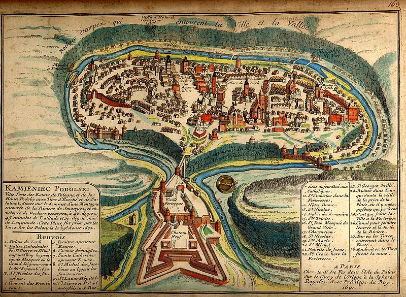
Українська: Давня французька мапа Кам'янця-Подільського 1691 після його захоплення турками
Русский: Старинная карта Каменца-Подольского 1691 года. |
||||||||||||||||||||
| Map legend |
Français : KAMIENIEC PODOLSKI Ville forte des Estats de Pologne, et de la Haute Podolie avec Titre d'Evéché et de Palatinat, située sur le Sommet d’une Montagne entourée de la Riviere de Smotrycz, et envelopée de Rochers escarpez, à 48. degrez 45. minutes de Latitude et 50. deg. 10. min. de Longitude. Cette Place fut prise par les Turcs sur Polonais le 29e Aoust 1672. Renvois
A PARIS |
||||||||||||||||||||
| Tarih | |||||||||||||||||||||
| Kaynak | brooks-planck.org | ||||||||||||||||||||
| Yaratıcı |
|
||||||||||||||||||||
| Georeferencing | If inappropriate please set warp_status = skip to hide. | ||||||||||||||||||||

Fortified city of the Polish State and of Upper Podolia, with the title of bishopric and palatinate [voivodeship], situated on top of a mountain surrounded by the Smotrycz River and enclosed by steep rocks, at 48°45’ latitude and 50°10’ longitude. This place was taken by the Turks from the Poles on 29 August 1672.
References
- Lech’s Palace
- Cathedral church of St Peter and St Paul, today the main mosque where the Grand Vizier entered on 3 September 1672
- St Nicholas’ [church] of the Dominicans
- Franciscan monastery
- Jesuits’ [church], now a stable
- Discalced Carmelites’ [church]
- St Catherine’s [church], now a stable
- Jesuits’ [church] of St Michael where the janissaries are quartered
- St Lazarus Hospital
- St Peter’s and St Paul’s [church], previously Ruthenian [Orthodox], today Catholic
- St Stanislaus’ [church] in the fortress
- Our Lady’s [church]
- St Nicholas’ [church]
- Armenian [Orthodox] church
- Holy Trinity [church]
- St John’s [church, now] Grand Vizier’s mosque
- Ascension [church]
- St Nicholas’ [church]
- St Mary’s [church]
- St Michael’s [church]
- Nativity [church]
- Holy Cross [church] outside the fortress
- St George’s [church], burnt
- Ruins of a tower which collapsed on the eve of the city’s capture, where 600 people perished
- Bridge linking the city with the fortress
- Canal linking the inlet and the outlet of the river
- [Place] where the Turks entered the moat
- Place where the Turks planted a mine
[Made] in Paris
At Mr. [Nicolas] De Fer’s [workshop] on the Palace Island on the Clock Quay at the Royal Sphere. With royal privilege, 1691.
Full text of the legend
| Annotations | This image is annotated: View the annotations at Commons |
Lisanslama
|
Bu çalışma ABD'de veya yazarın yaşamının sona ermiş olmasından 100 veya daha fazla süre geçtiğinde bu duruma uygun telif yasaları olan tüm ülkelerde kamu malıdır. | |
| Bu dosya ve ilgili diğer hakları da dahil olmak üzere telif hakkı kapsamında bilinen tüm kısıtlamalar, serbest lisans olarak belirlenmiştir. | |
Değerlendirme
|

Dosya geçmişi
Dosyanın herhangi bir zamandaki hâli için ilgili tarih/saat kısmına tıklayın.
| Tarih/Saat | Küçük resim | Boyutlar | Kullanıcı | Yorum | |
|---|---|---|---|---|---|
| güncel | 23.29, 18 Ekim 2007 | | 2.296 × 1.680 (1,58 MB) | DDima | {{Information |Description={{en|An 1691 map of the Ukrainian City of Kamianets-Podilskyi.}} {{ru|Старинная карта Каменца-Подольского 1691 года}} |Source=[[:ru:Изображени |
Dosya kullanımı
Bu görüntü dosyasına bağlantısı olan sayfalar:
- 1683-1699 Osmanlı-Lehistan Savaşı
- Kamaniçe Kalesi
- Kamaniçe Kuşatması (1684)
- Kamaniçe Muharebesi
- Kamyanets-Podilski
- Osmanlı-Kutsal İttifak savaşları
- Kullanıcı mesaj:Takabeg/Eski Mesajlar 2009 - 4
- Vikipedi:Günün seçkin resmi/Aralık 2021
- Vikipedi:Günün seçkin resmi/Eylül 2010
- Vikipedi:Seçkin resim adayları/Arşiv/Ekim 2009
- Vikipedi:Seçkin resim adayları/Kamianets-Podilskyi map 1691.jpg
- Vikipedi:Seçkin resimler/Ana sayfaya çıkmış resimler/2010 listesi
- Vikipedi:Seçkin resimler/Çizimler, diyagramlar ve haritalar/Haritalar
- Şablon:GSR/2010-09-03
- Şablon:GSR/2021-12-09
Küresel dosya kullanımı
Aşağıdaki diğer vikiler bu dosyayı kullanır:
- ast.wikipedia.org üzerinde kullanımı
- az.wikipedia.org üzerinde kullanımı
- be.wikipedia.org üzerinde kullanımı
- bg.wikipedia.org üzerinde kullanımı
- ca.wikipedia.org üzerinde kullanımı
- de.wikipedia.org üzerinde kullanımı
- dsb.wikipedia.org üzerinde kullanımı
- el.wikipedia.org üzerinde kullanımı
- en.wikipedia.org üzerinde kullanımı
- Wikipedia:WikiProject Former countries
- Podolian Voivodeship
- Kamianets-Podilskyi
- Portal:Ukraine
- Portal:Ukraine/Featured picture
- Portal talk:Ukraine/Featured picture
- Wikipedia:WikiProject Poland
- User:Sashazlv/Try
- Portal:History/Featured picture
- Wikipedia:WikiProject Urban studies and planning
- Portal:Maps/Selected picture
- Wikipedia:Featured pictures thumbs/08
- Wikipedia:WikiProject Ukraine
- User talk:DDima/Archive 3
- Wikipedia:Featured picture candidates/Kamianets-Podilskyi map
- Wikipedia:Wikipedia Signpost/2007-11-05/Features and admins
- Wikipedia:Featured picture candidates/November-2007
- Portal:Maps/Selected picture/30
- Wikipedia:Picture of the day/March 2008
- Kamianets-Podilskyi Castle
- Template:POTD/2008-03-09
- Wikipedia:Featured pictures/Diagrams, drawings, and maps/Maps
- Portal:Russia/Selected picture/11
- Wikipedia:Wikipedia Signpost/2007-11-05/SPV
- Podolia Eyalet
- Royal city in Polish–Lithuanian Commonwealth
- Portal:Poland/Recognized content
- Portal:Ukraine/Recognized content
- Wikipedia:WikiProject Former countries/Recognized content
- Wikipedia:Wikipedia Signpost/Single/2007-11-05
- en.wikivoyage.org üzerinde kullanımı
- es.wikipedia.org üzerinde kullanımı
- fr.wikipedia.org üzerinde kullanımı
Bu dosyanın daha fazla küresel kullanımını görüntüle.