
Dosya:Greece in 1210.svg

Bu SVG dosyasının PNG önizlemesinin boyutu: 800 × 456 piksel. Diğer çözünürlükler: 320 × 182 piksel | 640 × 365 piksel | 1.024 × 584 piksel | 1.280 × 730 piksel | 2.560 × 1.460 piksel | 3.508 × 2.000 piksel.
Tam çözünürlük (SVG dosyası, sözde 3.508 × 2.000 piksel, dosya boyutu: 1,12 MB)
Bu dosya Wikimedia Commons'ta bulunmaktadır. Dosyanın açıklaması aşağıda gösterilmiştir. Commons, serbest/özgür telifli medya dosyalarının bulundurulduğu depodur. Siz de yardım edebilirsiniz. |
Özet
| Açıklama |
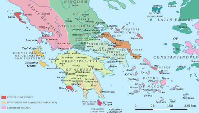
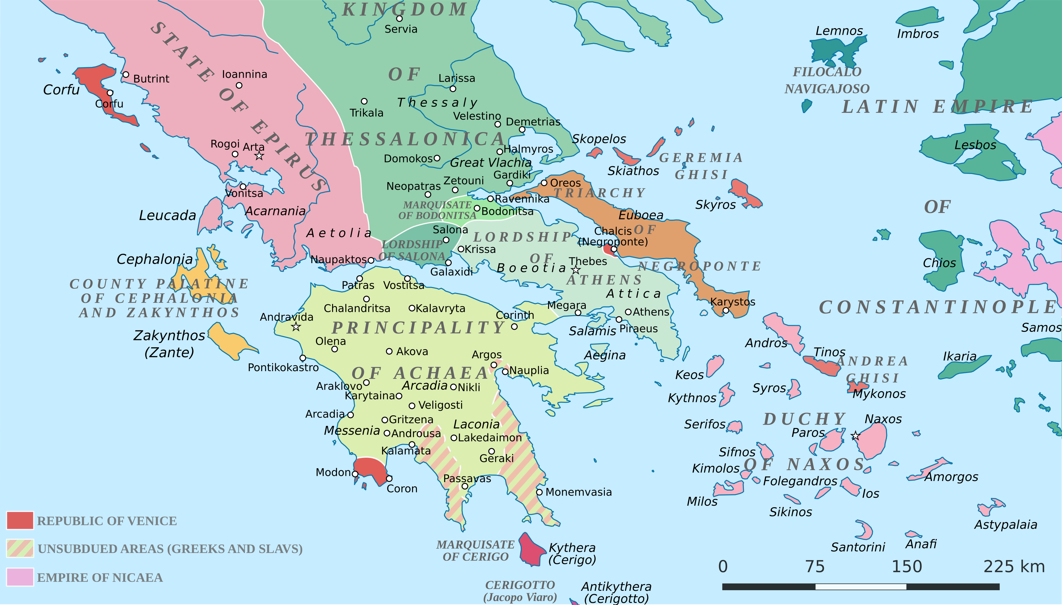
English: Political map of southern Greece in c. 1210, after the establishment of the Crusader states following the Fourth Crusade. |
| Tarih | |
| Kaynak |
SVG base from File:Greece in 1210V1.svg; based on the original political map by William Miller (1908), with changes and corrections to account for newer scholarship:
|
| Yazar | Cplakidas |
| Diğer sürümler |
|


Lisanslama
Ben, bu işin telif sahibi, burada işi aşağıdaki lisans altında yayımlıyorum:
Bu dosya, Creative Commons Atıf-Benzer Paylaşım 4.0 Uluslararası lisansı ile lisanslanmıştır.
- Şu seçeneklerde özgürsünüz:
- paylaşım – eser paylaşımı, dağıtımı ve iletimi
- içeriği değiştirip uyarlama – eser adaptasyonu
- Aşağıdaki koşullar geçerli olacaktır:
- atıf – Esere yazar veya lisans sahibi tarafından belirtilen (ancak sizi ya da eseri kullanımınızı desteklediklerini ileri sürmeyecek bir) şekilde atıfta bulunmalısınız.
- benzer paylaşım – Maddeyi yeniden karıştırır, dönüştürür veya inşa ederseniz, katkılarınızı orijinal olarak aynı veya uyumlu lisans altında dağıtmanız gerekir.
Dosya geçmişi
Dosyanın herhangi bir zamandaki hâli için ilgili tarih/saat kısmına tıklayın.
| Tarih/Saat | Küçük resim | Boyutlar | Kullanıcı | Yorum | |
|---|---|---|---|---|---|
| güncel | 19.59, 23 Haziran 2017 | | 3.508 × 2.000 (1,12 MB) | Cplakidas | fixed three names to paths |
| 12.08, 11 Nisan 2017 |  | 3.508 × 2.000 (1,1 MB) | Cplakidas | colour changes | |
| 11.48, 11 Nisan 2017 |  | 3.508 × 2.000 (1,11 MB) | Cplakidas | tweak around Coron | |
| 10.39, 11 Şubat 2017 |  | 3.508 × 2.000 (1,11 MB) | Cplakidas | tweaks in Negroponte, unsubdued areas | |
| 17.57, 8 Şubat 2017 |  | 3.508 × 2.000 (1,11 MB) | Cplakidas | tweaking the Morea | |
| 13.40, 8 Şubat 2017 |  | 3.508 × 2.000 (1,11 MB) | Cplakidas | slight tweaks | |
| 13.14, 8 Şubat 2017 |  | 3.508 × 2.000 (1,11 MB) | Cplakidas | User created page with UploadWizard |
Dosya kullanımı
Bu görüntü dosyasına bağlantısı olan sayfalar:
Küresel dosya kullanımı
Aşağıdaki diğer vikiler bu dosyayı kullanır:
- ar.wikipedia.org üzerinde kullanımı
- az.wikipedia.org üzerinde kullanımı
- bg.wikipedia.org üzerinde kullanımı
- ca.wikipedia.org üzerinde kullanımı
- da.wikipedia.org üzerinde kullanımı
- de.wikipedia.org üzerinde kullanımı
- el.wikipedia.org üzerinde kullanımı
- en.wikipedia.org üzerinde kullanımı
- eo.wikipedia.org üzerinde kullanımı
- eu.wikipedia.org üzerinde kullanımı
- fa.wikipedia.org üzerinde kullanımı
- fr.wikipedia.org üzerinde kullanımı
- gl.wikipedia.org üzerinde kullanımı
- hr.wikipedia.org üzerinde kullanımı
- id.wikipedia.org üzerinde kullanımı
- it.wikipedia.org üzerinde kullanımı
- ja.wikipedia.org üzerinde kullanımı
- ko.wikipedia.org üzerinde kullanımı
- ro.wikipedia.org üzerinde kullanımı
- ru.wikipedia.org üzerinde kullanımı
- sk.wikipedia.org üzerinde kullanımı
Bu dosyanın daha fazla küresel kullanımını görüntüle.