
Dosya:Decision Support System for John Day Reservoir.jpg
Daha yüksek çözünürlüğe sahip sürüm bulunmamaktadır.
Decision_Support_System_for_John_Day_Reservoir.jpg ((477 × 364 piksel, dosya boyutu: 178 KB, MIME tipi: image/jpeg))
Bu dosya Wikimedia Commons'ta bulunmaktadır. Dosyanın açıklaması aşağıda gösterilmiştir. Commons, serbest/özgür telifli medya dosyalarının bulundurulduğu depodur. Siz de yardım edebilirsiniz. |
Özet
| Açıklama |
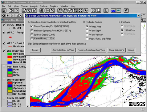
English: This set of tools, in conjunction with 2-dimensional hydraulic modeling, is being used to estimate the effects of reservoir level and water discharge fluctuations on aquatic and terrestrial habitats in John Day Reservoir. Different scenarios being studied now range from typical reservoir levels at high and low discharges to a simulation of what things might be like if the river were to return to natural conditions |
| Tarih | Retrieved June 17 2009. |
| Kaynak | http://wfrc.usgs.gov/research/geospatial%20studies/STGeospat4.htm ...returns HTTP status 404. The most recent non-404 snapshot of this page from archive.org is: https://web.archive.org/web/20100527105316/http://wfrc.usgs.gov/research/geospatial%20studies/STGeospat4.htm |
| Yazar | USGS: Project contact Michael J. Parsley, U.S. Geological Survey |
Lisanslama
Decision Support System for John Day Reservoir.jpg adlı görüntü kamu malıdır çünkü içeriği, ABD İç İşleri Bakanlığı (United States Department of Interior) bünyesindeki bir daire olan Birleşik Devletler Jeolojik Etüd (BDJE; United States Geological Survey, USGS) kökenli özgün malzeme ile ilgilidir.
Daha ayrıntılı bilgi için, bakın: BDJE'nin resmi telif hakkı uygulaması.
|
Dosya geçmişi
Dosyanın herhangi bir zamandaki hâli için ilgili tarih/saat kısmına tıklayın.
| Tarih/Saat | Küçük resim | Boyutlar | Kullanıcı | Yorum | |
|---|---|---|---|---|---|
| güncel | 11.40, 17 Haziran 2009 | | 477 × 364 (178 KB) | Mdd | {{Information |Description={{en|1=This set of tools, in conjunction with 2-dimensional hydraulic modeling, is being used to estimate the effects of reservoir level and water discharge fluctuations on aquatic and terrestrial habitats in John Day Reservoir. |
Dosya kullanımı
Bu görüntü dosyasına bağlantısı olan sayfalar:
Küresel dosya kullanımı
Aşağıdaki diğer vikiler bu dosyayı kullanır:
- ar.wikipedia.org üzerinde kullanımı
- el.wikipedia.org üzerinde kullanımı
- en.wikipedia.org üzerinde kullanımı
- es.wikipedia.org üzerinde kullanımı
- fa.wikipedia.org üzerinde kullanımı
- fr.wikipedia.org üzerinde kullanımı
- ja.wikipedia.org üzerinde kullanımı
- ko.wikipedia.org üzerinde kullanımı
- sr.wikipedia.org üzerinde kullanımı
- uk.wikipedia.org üzerinde kullanımı
- www.wikidata.org üzerinde kullanımı