
Dosya:Brown Pelican Diving 3-3 (used in NYPL article on the Gulf Oil Spill Disaster) (2843864615).jpg
Tam çözünürlük ((1.459 × 2.189 piksel, dosya boyutu: 1,39 MB, MIME tipi: image/jpeg))
Bu dosya Wikimedia Commons'ta bulunmaktadır. Dosyanın açıklaması aşağıda gösterilmiştir. Commons, serbest/özgür telifli medya dosyalarının bulundurulduğu depodur. Siz de yardım edebilirsiniz. |
_(2843864615).jpg)
Özet
| Açıklama |
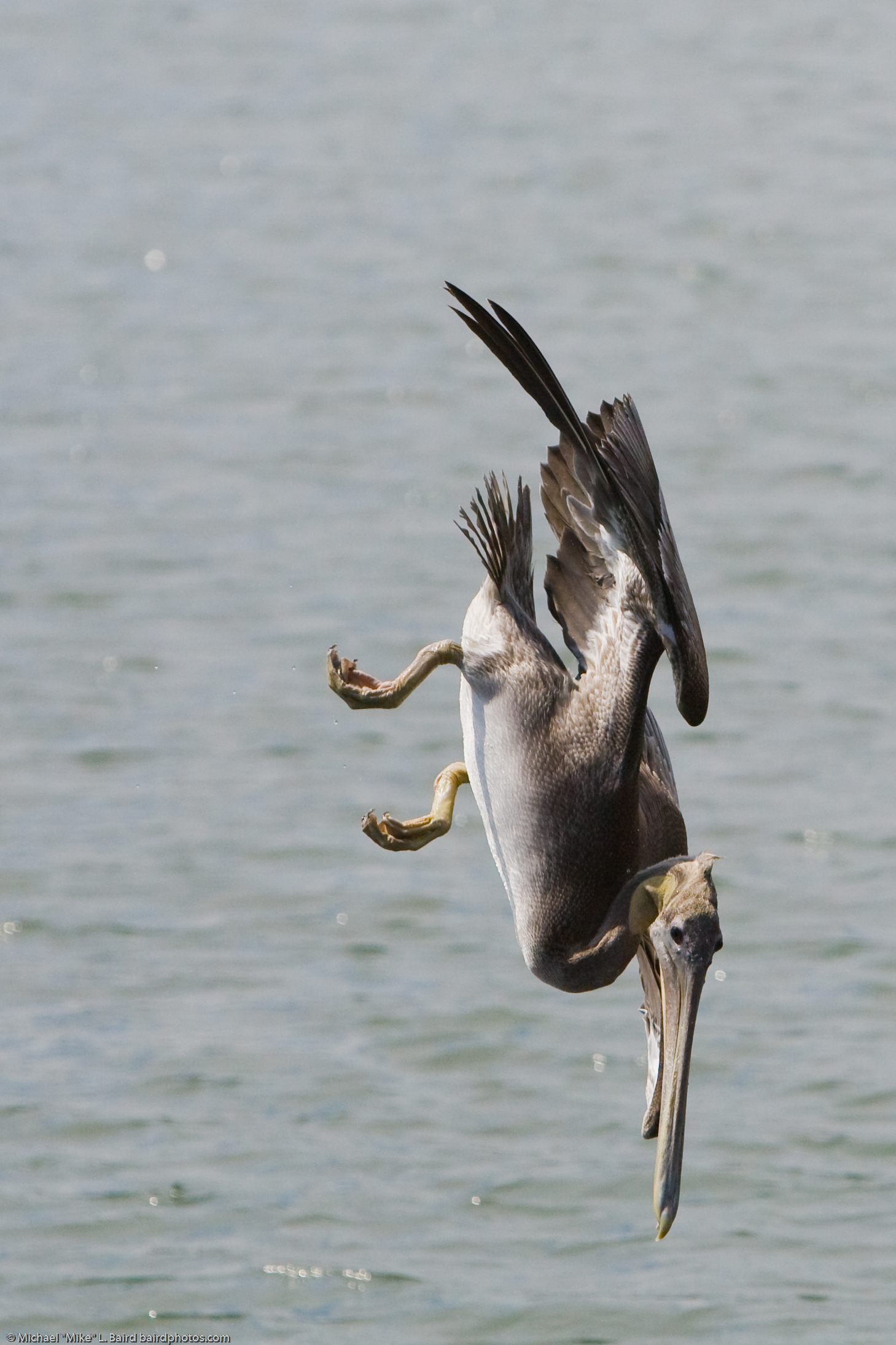
Brown Pelican 3/3 (Pelecanus occidentalis) diving for food, in Morro Bay State Park Marina 09 Sept 2008, Morro Bay, CA. (used in a NYPL article on the Gulf Oil Spill Disaster www.nypl.org/blog/2010/06/22/brown-pelican-reluctant-heroine ) Tech note: 1/8000th sec. helped to guarantee a sharp capture of this fast diving bird. Ten frames per second allowed me to select the pose and height from the water shown here. June 22, 2010. www.nypl.org/blog/2010/06/22/brown-pelican-reluctant-heroine where it says "This spectacular image of the Brown Pelican in action was shot at Morro State Park Marina taken on September, 09, 2008 by amateur photographer "Mike" Michael L.Baird. View Mr. Baird's other stunning images of the Brown Pelican on Flickr." Valerie Wingfield Specialist/Preservation Representative Library Services Center. LIC Manuscripts and Archives Division vwingfield [at} nypl d o t org
|
| Tarih | |
| Kaynak | Brown Pelican Diving 3/3 (used in NYPL article on the Gulf Oil Spill Disaster) |
| Yazar | Mike Baird from Morro Bay, USA |
| Kamera pozisyonu | | Bu ve diğer görüntülerin konumlarını şurada belirle: OpenStreetMap |
|---|
_(2843864615).jpg¶ms=035.344937_N_-120.840704_E_globe:Earth_type:camera_source:Flickr_&language=tr)
Lisanslama
- Şu seçeneklerde özgürsünüz:
- paylaşım – eser paylaşımı, dağıtımı ve iletimi
- içeriği değiştirip uyarlama – eser adaptasyonu
- Aşağıdaki koşullar geçerli olacaktır:
- atıf – Esere yazar veya lisans sahibi tarafından belirtilen (ancak sizi ya da eseri kullanımınızı desteklediklerini ileri sürmeyecek bir) şekilde atıfta bulunmalısınız.
| This image was originally posted to Flickr by mikebaird at https://www.flickr.com/photos/72825507@N00/2843864615. It was reviewed on 24 Nisan 2014 by FlickreviewR and was confirmed to be licensed under the terms of the cc-by-2.0. |
Dosya geçmişi
Dosyanın herhangi bir zamandaki hâli için ilgili tarih/saat kısmına tıklayın.
| Tarih/Saat | Küçük resim | Boyutlar | Kullanıcı | Yorum | |
|---|---|---|---|---|---|
| güncel | 11.35, 24 Nisan 2014 | | 1.459 × 2.189 (1,39 MB) | Smooth O | Transferred from Flickr via Flickr2commons |
Dosya kullanımı
Bu görüntü dosyasına bağlantısı olan sayfalar:
_(2843864615).jpg)