Dosya:Breakup of Yugoslavia.gif
Sayfa içeriği diğer dillerde desteklenmemektedir.
Vikipedi, özgür ansiklopedi

Tam çözünürlük((1.545 × 1.242 piksel, dosya boyutu: 187 KB, MIME tipi: image/gif), döngüye girdi, 14 kare, 44 sn)


This image could be re-created using vector graphics as an SVG file. This has several advantages; see Commons:Media for cleanup for more information. If an SVG form of this image is available, please upload it and afterwards replace this template with {{vector version available|new image name}}. It is recommended to name the SVG file "Breakup of Yugoslavia.svg" - then the template Vector version available (or Vva) does not need the new image name parameter.

Özet

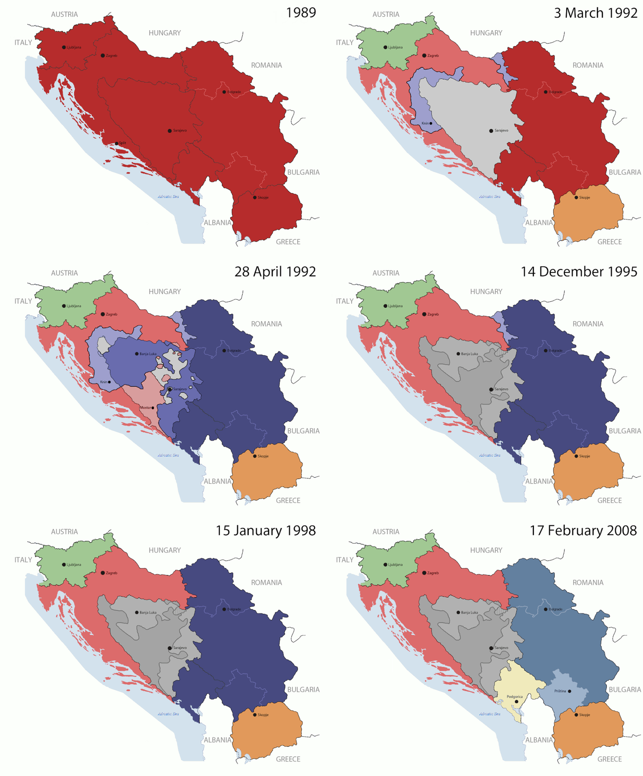
Key:

Yugoslavia (1943–1992) SFR Yugoslavia
Croatia (1991–present) Croatia
Herzeg-Bosnia (1992–1994)
UNTAES (1996–1998)
Federal Republic of Yugoslavia / Serbia and Montenegro (1992–2006) Serbia and Montenegro
Republika Srpska (1992–present) Republika Srpska
Serbian Krajina (1991–1995/96)
Republic of Bosnia and Herzegovina (1992–1995)
Bosnia and Herzegovina (1998–present) Bosnia and Herzegovina
Western Bosnia (1993–1995)
Serbia (2006–present) Serbia
Kosovo (under UNMIK control 1999–present; declaration of independence 2008) Kosovo
Montenegro (2006–present) Montenegro
Macedonia (1991–present) Macedonia
Slovenia (1991–present) Slovenia


Açıklama

This is an animated GIF that shows the stages of the breakup of the SFR Yugoslavia in the 90's and 2000's. The map based off Morwen's map of the divisions of the SFRY, Which is licensed by the GFDL. The source for the dates of independence is the CIA World Factbook. These maps do not now show the Inter-Entity Boundary Line (IEBL) and/or the entities that are separated by it. The IEBL has been drawn based on this CIA map; the Brčko District has been drawn based on Image:BH municipality location.gif, by user:Ante Perkovic. I might add them in the future.

Since the original map was GFDL, this image is as well.

A map depicting Kosovo's final status is ready once it takes effect.


Changelog for versions 2/3:

Here are some changes in this new build of the map:

  • The Kosovo boundary has been given a shade of red instead of the previous UN blue since they are a province of Serbia under UNIMIK control.
  • Montenegro's color has been changed to a golden shade close to what's on the flag.
  • The IEBL and the Brčko District has been redrawn because I deleted the original map; the color for the Republika Srpska is lighter.
  • The dates are at the top left hand corner of the map instead of the bottom.
  • I have taken a new approach as to the boundaries. Each part of Yugoslavia now shows the boundary on the maps starting the year they broke away. I feel this change helps readers understand the breakup better.
  • The SFRY and the FRY are in different shades since the FRY was never accepted as the successor to the former by the UN.
  • The colors for the entities of BiH have been removed as to not confuse people into thinking that they are independent states. What remains is the IEBL with both entities in green.
  • The Kosovo boundary is finally in hash marks!
  • The Brčko District has been removed. The sale is too small to show accurately.

Changelog for version 4:

  • The map is larger!
  • The image has been rebuilt to include the eastern part of FYR Macedonia.
  • The image has been updated to take in Kosovo's new status.
  • The IEBL is now a darker line.
  • Montenegro, Kosovo, and FRY/SCG/Serbia have new colors!

Changelog for version 5:

  • Rebuilt
  • Larger map: size of base image
  • Accurate Inter-Entity Boundary Line
Tarih 24 July 2006 (orginal upload date)
Kaynak Made by Hoshie; see above for more details on sources.
Yazar Hoshie
Diğer sürümler

Lisanslama

GNU head Bu belgenin GNU Özgür Belgeleme Lisansı, Sürüm 1.2 veya Özgür Yazılım Vakfı tarafından yayımlanan sonraki herhangi bir sürüm şartları altında bu belgenin kopyalanması, dağıtılması ve/veya değiştirilmesi için izin verilmiştir;

Değişmeyen Bölümler, Ön Kapak Metinleri ve Arka Kapak Metinleri yoktur. Lisansın bir kopyası GNU Özgür Belgeleme Lisansı sayfasında yer almaktadır.

w:tr:Creative Commons
atıf benzer paylaşım
Bu dosya, Creative Commons Atıf-Benzer Paylaşım 3.0 Taşınmamış lisansı ile lisanslanmıştır
Şu seçeneklerde özgürsünüz:
  • paylaşım – eser paylaşımı, dağıtımı ve iletimi
  • içeriği değiştirip uyarlama – eser adaptasyonu
Aşağıdaki koşullar geçerli olacaktır:
  • atıf – Esere yazar veya lisans sahibi tarafından belirtilen (ancak sizi ya da eseri kullanımınızı desteklediklerini ileri sürmeyecek bir) şekilde atıfta bulunmalısınız.
  • benzer paylaşım – Maddeyi yeniden karıştırır, dönüştürür veya inşa ederseniz, katkılarınızı orijinal olarak aynı veya uyumlu lisans altında dağıtmanız gerekir.
Bu lisanslama etiketi, dosyaya GFDL lisanslama güncelleştirmenin bir parçası olarak eklenmiştir.

Altyazılar

Bu dosyanın temsil ettiği şeyin tek satırlık açıklamasını ekleyin.

Bu dosyada gösterilen öğeler

betimlenen

image/gif

05ca2aefea8406b809968643552d5095c847a42f

191.625 Bayt

44 saniye

1.242 piksel

1.545 piksel

Dosya geçmişi

Dosyanın herhangi bir zamandaki hâli için ilgili tarih/saat kısmına tıklayın.

(en yeni | en eski) (10 daha yeni) () (10 | 20 | 50 | 100 | 250 | 500)
Tarih/SaatKüçük resimBoyutlarKullanıcıYorum
güncel07.40, 17 Temmuz 201607.40, 17 Temmuz 2016 tarihindeki sürümün küçültülmüş hâli1.545 × 1.242 (187 KB)מפתח-רשימהReverted to version as of 17:22, 21 August 2015 (UTC)
17.22, 21 Ağustos 201517.22, 21 Ağustos 2015 tarihindeki sürümün küçültülmüş hâli1.463 × 1.158 (1,81 MB)BraganzaReverted to version as of 03:57, 19 January 2010
17.22, 21 Ağustos 201517.22, 21 Ağustos 2015 tarihindeki sürümün küçültülmüş hâli1.545 × 1.242 (187 KB)BraganzaReverted to version as of 01:02, 19 December 2011
17.15, 21 Ağustos 201517.15, 21 Ağustos 2015 tarihindeki sürümün küçültülmüş hâli120 × 95 (3 KB)Braganza03:57, 19. Jan. 2010
01.02, 19 Aralık 201101.02, 19 Aralık 2011 tarihindeki sürümün küçültülmüş hâli1.545 × 1.242 (187 KB)DIREKTORAdded details
18.09, 27 Temmuz 201118.09, 27 Temmuz 2011 tarihindeki sürümün küçültülmüş hâli1.545 × 1.242 (170 KB)DIREKTORSmall fixes
17.28, 27 Temmuz 201117.28, 27 Temmuz 2011 tarihindeki sürümün küçültülmüş hâli1.545 × 1.242 (171 KB)DIREKTORAdded UNMIK
16.38, 27 Temmuz 201116.38, 27 Temmuz 2011 tarihindeki sürümün küçültülmüş hâli1.545 × 1.242 (165 KB)DIREKTORDates for the last two frames.
12.10, 27 Temmuz 201112.10, 27 Temmuz 2011 tarihindeki sürümün küçültülmüş hâli1.545 × 1.242 (149 KB)DIREKTORLighter shade for country names
16.59, 26 Temmuz 201116.59, 26 Temmuz 2011 tarihindeki sürümün küçültülmüş hâli1.545 × 1.242 (170 KB)DIREKTORHigher res plus details
(en yeni | en eski) (10 daha yeni) () (10 | 20 | 50 | 100 | 250 | 500)

Bu görüntü dosyasına bağlanan sayfa yok.

Küresel dosya kullanımı

Aşağıdaki diğer vikiler bu dosyayı kullanır:

Bu dosyanın daha fazla küresel kullanımını görüntüle.

Meta veri