
Dosya:Blue Marble 2002.png

Tam çözünürlük ((43.200 × 21.600 piksel, dosya boyutu: 529,58 MB, MIME tipi: image/png))
Bu dosya Wikimedia Commons'ta bulunmaktadır. Dosyanın açıklaması aşağıda gösterilmiştir. Commons, serbest/özgür telifli medya dosyalarının bulundurulduğu depodur. Siz de yardım edebilirsiniz. |
Özet
| Uyarı | Bu dosya çok yüksek çözünürlüğe sahip. Tam boyutunda açılmaya çalışıldığı taktirde doğru yüklenmeyebilir veya tarayıcınızın donmasına neden olabilir. Bu sorunlardan kaçınmak için ZoomViewer kullanın. |
|---|
| Açıklama |
العربية: صور ساتليَّة مُجمَّعة لتُظهر سطح الأرض كاملًا.
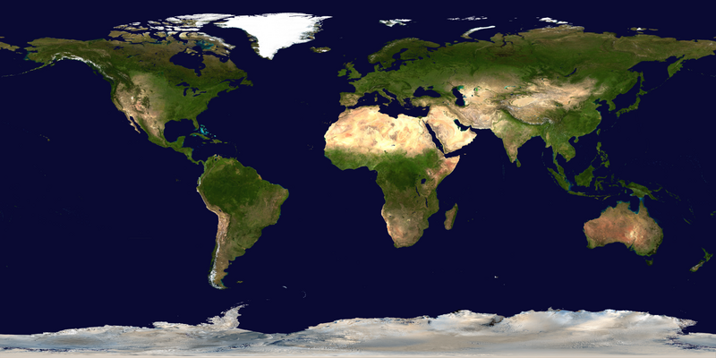
English: This spectacular “blue marble” image is the most detailed true-color image of the entire Earth to date. Using a collection of satellite-based observations, scientists and visualizers stitched together months of observations of the land surface, oceans, sea ice, and clouds into a seamless, true-color mosaic of every square kilometer (.386 square mile) of our planet. These images are freely available to educators, scientists, museums, and the public.
Much of the information contained in this image came from a single remote-sensing device-NASA’s Moderate Resolution Imaging Spectroradiometer, or MODIS. Flying over 700 km above the Earth onboard the Terra satellite, MODIS provides an integrated tool for observing a variety of terrestrial, oceanic, and atmospheric features of the Earth. The land and coastal ocean portions of these images are based on surface observations collected from June through September 2001 and combined, or composited, every eight days to compensate for clouds that might block the sensor’s view of the surface on any single day. Two different types of ocean data were used in these images: shallow water true color data, and global ocean color (or chlorophyll) data. Topographic shading is based on the GTOPO 30 elevation dataset compiled by the U.S. Geological Survey’s EROS Data Center. MODIS observations of polar sea ice were combined with observations of Antarctica made by the National Oceanic and Atmospheric Administration’s AVHRR sensor—the Advanced Very High Resolution Radiometer. The cloud image is a composite of two days of imagery collected in visible light wavelengths and a third day of thermal infra-red imagery over the poles. Global city lights, derived from 9 months of observations from the Defense Meteorological Satellite Program, are superimposed on a darkened land surface map. |
| Tarih | |
| Kaynak | NASA Visible Earth: Blue Marble: Land Surface, Shallow Water, and Shaded Topography |
| Yazar | NASA’s Terra satellite for the MODIS imageries, combined by Meow. Credit: NASA Goddard Space Flight Center Image by Reto Stöckli (land surface, shallow water, clouds). Enhancements by Robert Simmon (ocean color, compositing, 3D globes, animation). Data and technical support: MODIS Land Group; MODIS Science Data Support Team; MODIS Atmosphere Group; MODIS Ocean Group Additional data: USGS EROS Data Center (topography); USGS Terrestrial Remote Sensing Flagstaff Field Center (Antarctica); Defense Meteorological Satellite Program (city lights). |
| Diğer sürümler |
|
.png)


Değerlendirme
|
Lisanslama
| Bu dosya NASA tarafından üretildiği için kamu malıdır. Aksi belirtilmediği sürece "NASA tarafından üretilen malzemenin telif hakkı olmadığı" NASA telif politikasında belirtilmiştir. (Bkz. Template:PD-USGov, NASA copyright policy page veya JPL Image Use Policy.) | ||
 |
Uyarılar:
|
Dosya geçmişi
Dosyanın herhangi bir zamandaki hâli için ilgili tarih/saat kısmına tıklayın.
| Tarih/Saat | Küçük resim | Boyutlar | Kullanıcı | Yorum | |
|---|---|---|---|---|---|
| güncel | 10.34, 23 Temmuz 2023 | | 43.200 × 21.600 (529,58 MB) | Gioppolognomo | Reverted to version as of 11:53, 5 August 2016 (UTC) |
| 10.28, 23 Temmuz 2023 |  | 5.400 × 2.700 (41,8 MB) | Gioppolognomo | ||
| 11.53, 5 Ağustos 2016 |  | 43.200 × 21.600 (529,58 MB) | Meow | c:User:Rillke/bigChunkedUpload.js: |
Dosya kullanımı
Bu görüntü dosyasına bağlantısı olan sayfalar:
Küresel dosya kullanımı
Aşağıdaki diğer vikiler bu dosyayı kullanır:
- ar.wikipedia.org üzerinde kullanımı
- bcl.wikipedia.org üzerinde kullanımı
- bn.wikipedia.org üzerinde kullanımı
- en.wikipedia.org üzerinde kullanımı
- Earth observation satellite
- World map
- Equirectangular projection
- Wikipedia:Featured pictures thumbs/04
- User talk:Nnfolz
- Wikipedia:Featured pictures/Space/Looking back
- Talk:Fishing vessel
- User:Huggums537
- Template talk:GeoTemplate/Archive 15
- Wikipedia:Featured picture candidates/delist/2020
- Wikipedia:Featured picture candidates/delist/Blue Marble
- User:GTAVCV20022013
- User:Hurricane Noah/TCMap/Current
- User:Hurricane Noah/TCMap
- User:Hurricane Noah/TCMap/Maps
- User talk:HighInBC/Archive 83
- User:LoekVV
- Portal:World
- Wikipedia:Picture of the day/January 2023
- User:SuperPentagonAnimations/sandbox
- Wikipedia talk:WikiProject Weather/Colour discussions
- Template:POTD/2023-01-11
- Wikipedia:Main Page history/2023 January 11
- Wikipedia:Main Page history/2023 January 11b
- en.wikibooks.org üzerinde kullanımı
- fa.wikipedia.org üzerinde kullanımı
- fr.wikipedia.org üzerinde kullanımı
- ha.wikipedia.org üzerinde kullanımı
- he.wikipedia.org üzerinde kullanımı
- it.wikibooks.org üzerinde kullanımı
- mk.wikipedia.org üzerinde kullanımı
- pnb.wikipedia.org üzerinde kullanımı
- th.wikipedia.org üzerinde kullanımı
- tum.wikipedia.org üzerinde kullanımı
- tw.wikipedia.org üzerinde kullanımı
- ur.wikipedia.org üzerinde kullanımı
- vi.wikipedia.org üzerinde kullanımı