
Dosya:Bessarabia.png

Tam çözünürlük ((544 × 607 piksel, dosya boyutu: 49 KB, MIME tipi: image/png))
Bu dosya Wikimedia Commons'ta bulunmaktadır. Dosyanın açıklaması aşağıda gösterilmiştir. Commons, serbest/özgür telifli medya dosyalarının bulundurulduğu depodur. Siz de yardım edebilirsiniz. |
Özet
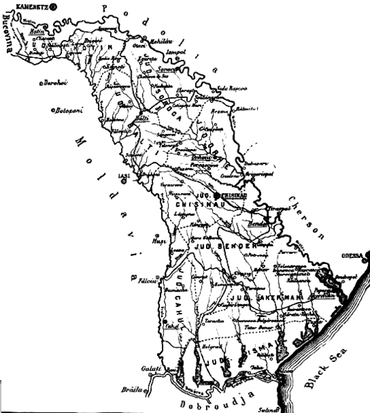
| Açıklama |
English: The map of the region of Bessarabia (1812-1917) Română: Harta Basarabiei Русский: Карта Бессарабии |
| Tarih | |
| Kaynak | http://depts.washington.edu/cartah/text_archive/clark/b_22.jpg |
| Yazar | Celeron |
Lisanslama
|
Bu çalışma ABD'de veya yazarın yaşamının sona ermiş olmasından 70 veya daha fazla süre geçtiğinde bu duruma uygun telif yasaları olan tüm ülkelerde kamu malıdır.
| |
| Bu dosya ve ilgili diğer hakları da dahil olmak üzere telif hakkı kapsamında bilinen tüm kısıtlamalar, serbest lisans olarak belirlenmiştir. | |
Comment 1
better version of map at 
Comment 2
This map is from the book "Bessarabia, Russia, and Roumania on the Black Sea" by Charles Upson Clark.
An electronic version of the book is available online: http://depts.washington.edu/cartah/text_archive/clark/meta_pag.shtml
Dosya geçmişi
Dosyanın herhangi bir zamandaki hâli için ilgili tarih/saat kısmına tıklayın.
| Tarih/Saat | Küçük resim | Boyutlar | Kullanıcı | Yorum | |
|---|---|---|---|---|---|
| güncel | 20.52, 19 Mayıs 2006 | | 544 × 607 (49 KB) | Zserghei | This image was copied from wikipedia:en. The original description was: {{PD}} ==Comment 1== better version of map at Image:Bessarabia.jpg ==Comment 2== This map is from the book "Bessarabia, Russia, and Roumania on the Black Sea" by Charles Upson C |
| 00.47, 3 Ekim 2005 |  | 544 × 607 (49 KB) | Celeron | {{pd}} bessarabia's map |
Dosya kullanımı
Bu görüntü dosyasına bağlantısı olan sayfalar:
Küresel dosya kullanımı
Aşağıdaki diğer vikiler bu dosyayı kullanır:
- ar.wikipedia.org üzerinde kullanımı
- ast.wikipedia.org üzerinde kullanımı
- beta.wikiversity.org üzerinde kullanımı
- ca.wikipedia.org üzerinde kullanımı
- cs.wikipedia.org üzerinde kullanımı
- dsb.wikipedia.org üzerinde kullanımı
- en.wikipedia.org üzerinde kullanımı
- es.wikipedia.org üzerinde kullanımı
- eu.wikipedia.org üzerinde kullanımı
- id.wikipedia.org üzerinde kullanımı
- is.wikipedia.org üzerinde kullanımı
- it.wikipedia.org üzerinde kullanımı
- ko.wikipedia.org üzerinde kullanımı
- mk.wikipedia.org üzerinde kullanımı
- ms.wikipedia.org üzerinde kullanımı
- nl.wikipedia.org üzerinde kullanımı
- no.wikipedia.org üzerinde kullanımı
- pl.wikipedia.org üzerinde kullanımı
- pnb.wikipedia.org üzerinde kullanımı
- ro.wikipedia.org üzerinde kullanımı
- sl.wikipedia.org üzerinde kullanımı
- sq.wikipedia.org üzerinde kullanımı
- sv.wikipedia.org üzerinde kullanımı
- uk.wikipedia.org üzerinde kullanımı
- ur.wikipedia.org üzerinde kullanımı
- vi.wikipedia.org üzerinde kullanımı
- zh.wikipedia.org üzerinde kullanımı