
Dosya:Twin Cities Zephyr Oregon Illinois early 1940s.jpg
Tam çözünürlük ((1.150 × 763 piksel, dosya boyutu: 239 KB, MIME tipi: image/jpeg))
Bu dosya Wikimedia Commons'ta bulunmaktadır. Dosyanın açıklaması aşağıda gösterilmiştir. Commons, serbest/özgür telifli medya dosyalarının bulundurulduğu depodur. Siz de yardım edebilirsiniz. |
Özet
| Açıklama |
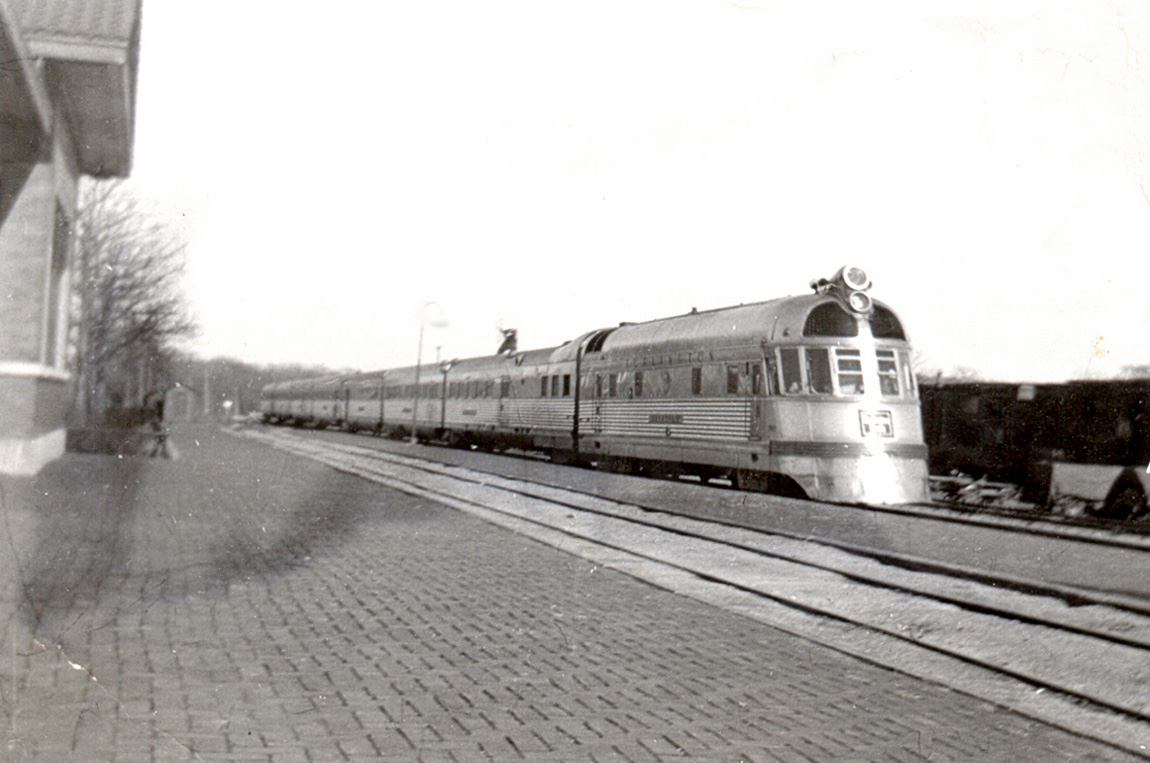
The Burlington Zephyr in the early 1940s. This is the Twin Cities Zephyr, which ran between Chicago and Minneapolis-St. Paul. This was the second route on which the Burlington Route (or CB&Q) used the Zephyr. There were two trains in each direction every day, the Morning Zephyr and the Afternoon Zephyr. The Zephyr was a new concept in passenger trains, with stainless steel cars by Budd Co. and a diesel engine by General Motors. It had a fixed trainset with a set of wheels joining each pair of cars, rather than each car having two sets of wheels. All of this made the train lighter, and potentially gave higher speed. The first Zephyr in 1934 was the Pioneer Zephyr. a three-car trainset. The Twin Cities Zephyr began with a similar trainset in 1935, but this longer set replaced it in 1936. This trainset stayed in service until 1947. At one time, the Twin Cities Zephyr was the fastest train in the world. It traveled 427 miles (687 km) between Chicago and St. Paul in six hours, for an average speed (including stops) of 71 mph (114 kph). The highest speed was on the segment between Prairie du Chien and East Dubuque, Illinois, 84 mph (135 kph). When my family went from Rockford to Prairie du Chien, we went to Oregon by bus, where we caught the Zephyr. Oregon is about 25 miles (40 km) southwest of Rockford. The train trip was about two hours. It appears that my father took this photo at the Oregon station. Light and shadows suggest that this is the Afternoon Zephyr. Zephyr is not a common word. It means a breeze from the west. |
| Kaynak |
Oregon, Illinois - Twin Cities Zephyr (early 1940s)
|
| Yazar | Roger Wollstadt from Sarasota, Florida |
| Kamera pozisyonu | | Bu ve diğer görüntülerin konumlarını şurada belirle: OpenStreetMap |
|---|
Lisanslama
- Şu seçeneklerde özgürsünüz:
- paylaşım – eser paylaşımı, dağıtımı ve iletimi
- içeriği değiştirip uyarlama – eser adaptasyonu
- Aşağıdaki koşullar geçerli olacaktır:
- atıf – Esere yazar veya lisans sahibi tarafından belirtilen (ancak sizi ya da eseri kullanımınızı desteklediklerini ileri sürmeyecek bir) şekilde atıfta bulunmalısınız.
- benzer paylaşım – Maddeyi yeniden karıştırır, dönüştürür veya inşa ederseniz, katkılarınızı orijinal olarak aynı veya uyumlu lisans altında dağıtmanız gerekir.
| Özgün hali Flickr'de yayınlanan bu resim, 29 Mart 2012 tarihinde bir hizmetli veya lisans inceleyicisi File Upload Bot (Magnus Manske) tarafından, Flickr'da o tarihte belirtilen lisans altında yayınlandığı incelendi. |
Dosya geçmişi
Dosyanın herhangi bir zamandaki hâli için ilgili tarih/saat kısmına tıklayın.
| Tarih/Saat | Küçük resim | Boyutlar | Kullanıcı | Yorum | |
|---|---|---|---|---|---|
| güncel | 01.11, 29 Mart 2012 | | 1.150 × 763 (239 KB) | File Upload Bot (Magnus Manske) | Transferred from Flickr by User:We hope using flickr2commons |
Dosya kullanımı
Bu görüntü dosyasına bağlantısı olan sayfalar:
Küresel dosya kullanımı
Aşağıdaki diğer vikiler bu dosyayı kullanır:
- bn.wikipedia.org üzerinde kullanımı
- en.wikipedia.org üzerinde kullanımı
- hu.wikipedia.org üzerinde kullanımı
- www.wikidata.org üzerinde kullanımı